Drone Crime Scene Mapping: Revolutionizing Investigations 🗺️
For those of us who love the whir of the rotors and the satisfying click of a well-executed aerial maneuver, seeing drones used for good in the world is always a thrill. And let me tell you, the way law enforcement is now employing drones for crime scene mapping is nothing short of revolutionary. Forget the days of painstaking manual measurements and potentially compromised evidence. We’re talking about capturing incredibly detailed 3D models from the air, offering a perspective and level of accuracy that was previously unimaginable. These aren’t just pretty pictures, folks; they’re interactive, measurable digital records of reality, preserving critical details with centimeter-level precision. Think of it – a bird’s-eye view, documenting everything from tire tracks to the spatial relationships between objects, all captured swiftly and safely. Curious about how this tech is changing the game? Let’s dive into some key insights gleaned from recent YouTube explorations, showcasing how drones are taking crime scene investigations to new heights – literally!
Key Takeaways on Drones Revolutionizing Crime Scene Mapping
Speed and Efficiency are Game Changers: The Pearland PD (Video 1) nails it. Documenting crash scenes used to be a major bottleneck, causing significant traffic delays. The DJI Mavic 3 Enterprise, as they demonstrate, dramatically reduces the time needed, allowing roads to reopen much faster. We’re talking about minutes instead of hours in some cases. Imagine the impact on commuters and the reduced risk of secondary accidents. The ability to quickly capture a scene before environmental factors can alter it is also a huge advantage.
Uncompromising Accuracy for Ironclad Evidence: It’s not just about speed; it’s about precision. Multiple videos (like Video 1 and 3) highlight the ability to generate 3D models with "centimeter accuracy." This level of detail is critical for accurate reconstructions and can be the difference between a successful prosecution and a case going cold. Think about analyzing the trajectory of a bullet or the precise location of key evidence – drone-captured data provides an objective and highly accurate record.
Enhanced Safety for First Responders: The Skydio video (Video 2) rightly emphasizes the safety aspect. Sending a drone to survey a potentially hazardous scene – be it a traffic accident or a more serious crime – keeps personnel out of harm’s way. Instead of investigators physically walking through a scene, potentially disturbing evidence or facing unforeseen dangers, the drone provides a safe and comprehensive overview. This "privileged situational awareness from a safe position" is invaluable.
Nighttime Investigations Illuminated: The collaboration showcased by Sundance Media Group, FoxFury, Pix4D, and Autel Robotics (Videos 3 & 4) on nighttime crime scene mapping is particularly fascinating for us tech enthusiasts. Using powerful, color-accurate lighting solutions like FoxFury’s Nomad T56 allows for detailed data capture even in complete darkness. The fact that they could generate usable 2D and 3D maps using Pix4D software with data from drones like the Autel Evo in low-light conditions demonstrates a significant leap forward. Imagine the implications for solving crimes that occur at night – crucial details that might be missed with traditional methods can now be meticulously documented.
Cost-Effectiveness and Wider Adoption: The Queensland Police Service’s adoption of drone technology (Video 5) points towards the practical and economic benefits. They explicitly mention that implementing drones is "less than mapping methods previously used." This is a significant factor driving wider adoption within law enforcement agencies. As the technology becomes more accessible and affordable, we’ll likely see more departments embracing its capabilities.
Real-World Impact on Serious Cases: The mention in the 13WMAZ news report (Video 6) of Monroe County deputies using drones to map the scene of a serious crime like a rape and murder case underscores the real-world impact of this technology. It’s not just theoretical; drones are actively contributing to solving complex and sensitive cases. This provides tangible evidence of the value drones bring to investigations.
The Future is in the Air: Autonomous Capabilities and Data Integration
Watching these developments, you can’t help but wonder what’s next. The Skydio video touches on the idea of "intelligent drones" capable of providing "actionable aerial intelligence." This hints at a future where drones become even more autonomous, potentially capable of identifying and tagging specific evidence markers themselves using AI-powered object recognition. Imagine drones seamlessly integrating with existing crime analysis software, feeding real-time data into a comprehensive investigative platform. We’re moving towards a future where the skies provide not just a visual record, but a dynamic and intelligent data stream, constantly informing and assisting investigators on the ground. The advancements in software, like Pix4D, that can quickly process the captured imagery into usable maps and models are also crucial, allowing for near real-time analysis in some scenarios.
Taking Investigations Sky High
The evidence is clear: drones are no longer just toys for hobbyists like us. They are transforming crime scene investigations, offering unparalleled speed, accuracy, and safety benefits. From rapidly clearing traffic accident sites to meticulously documenting complex crime scenes under the cover of darkness, these aerial assistants are proving their worth time and time again. It’s an exciting time to be following this technology, and the videos highlighted below offer a fascinating glimpse into this revolution in action. Scroll down and see for yourself the power of drones in bringing clarity and precision to the pursuit of justice.
Continue scrolling for the videos
How Pearland PD investigates crash scenes using DJI Mavic 3 EnterpriseDJI Enterprise20,693 views | 298 | November 29 2022 13:00:13 (19 comments)[ Read more … ]
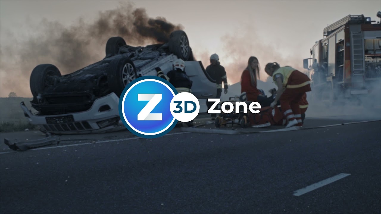
When accidents occur, it’s imperative to clear them out as quickly as possible without jeopardizing the integrity of the crash scene. The slightest mistake can cause investigations to go off-tangent or even become unsolvable.
The Pearland Police Department has developed a crash reconstruction program by documenting crash scenes through 3D models generated by drones. By using the Mavic 3 Enterprise, the PD can keep personnel safe, significantly decrease the amount of time spent documenting the crash scene, preserve the integrity of the crash scene with minimal evidence contamination, and, most importantly, reopen the flow of traffic to avoid significant traffic jams. Actual crash scenes are preserved in 3D with detailed information and centimeter accuracy.
To learn more about accident reconstruction using the Mavic 3 Enterprise, check out this blog post-http://bit.ly/3gOamEv
Special thanks to Pearland Police Department: http://bit.ly/3EPy9vO Produced by @Redcordproductions
Learn more: DJI Mavic 3 Enterprise 👉 http://bit.ly/3gJ8UU2 Top 7 Features of Mavic 3 Enteprise 👉 http://bit.ly/3F52gkm
Advertisement
Drones for Crime Scene Reconstruction – Episode 4Skydio2,884 views | 48 | January 2 2023 17:56:55 (3 comments)[ Read more … ]
First responders have some of the most difficult jobs on the planet. On a daily basis, they put their safety on the line to protect our communities. The use of public safety drones holds enormous potential to help first responders accelerate emergency response and gain privileged situational awareness from a safe position.
Skydio, the leading American drone manufacturer, believes the responsible use of drones is the core of any public safety mission and we bake responsible engagement into our DNA. We developed the Skydio Engagement and Responsible Use Principles—a groundbreaking set of policy and ethical principles to guide our work and drive the industry forward. We also partnered with DRONERESPONDERS—the leading association focused on first responder drone programs—to develop the “Five C’s” of responsible drone use by public safety agencies.
Now comes the second installment of the Skydio Original Series, Autonomous Drones for First Responders. It tells the story of first responders facing four different missions, from fire fighting to search and rescue and law enforcement, highlighting what happens when public safety operations are conducted with the support of an intelligent drone capable of providing actionable aerial intelligence.
UAV mapping for Crime Scene InvestigationFOXFURYLED6,744 views | 50 | February 20 2019 21:52:27 (2 comments)[ Read more … ]
Sundance Media Group along with FoxFury Lighting Solutions, Pix4D, and Autel Robotics hosted a nighttime drone crime scene investigation demonstration in Henderson, Nevada. Recreating a murder scene at a local equestrian park, the demonstration sought to use drones to capture forensic evidence at the scene in the dark and map it in 2D and 3D for law enforcement use.
Sundance Media Group crew worked to show what would happen if law enforcement was discovering the murder scene and mapping it for the first time.
A model, outfitted with moulage, laid out as a murder victim. FoxFury Lighting Solutions provided four Nomad T56 Scene Lights to illuminate the surrounding area to aid with photo and video capture. These lights offer 95 CRI 5600K daylight balanced light allowing accurate color representations in the photos and video collected, which is extremely important when examining the scene at a later date. Other scene lights were positioned around the park for attendee safety and location marking.
Two drone launch pads were positioned at one end of the scene, one holding an Autel Evo, the other holding a Yuneec H520. The Autel Evo flew for 30 minutes, manually capturing 60 frames per second of 4k resolutions images as well as recording video up to 100mbps. This was the first time Autel showcased their new LiveDeck ™ technology, allowing the aircraft footage to be seen LIVE at the Sundance Media Group A.V.O.C. (Aerial Vehicle Operations Center). Once the data was captured, it was imported into Pix4D Mapping software where it verified the images and began to compile maps and models of the scene that were available for attendees to view on a large monitor within a few minutes.
The goal of this demonstration was to show attendees how this combination of portable lighting, drone hardware, and mapping software can significantly reduce field and surveying time for law enforcement officials while increasing the accuracy of the investigation. There is also a safety benefit as officials can evaluate a scene from a safe distance rather than putting themselves in harm’s way.
Due to an increased demand in this type of data gathering, similar demonstrations and workshops will be offered throughout the year. Information will be posted through Sundance Media Group and FoxFury Lighting Solutions as it becomes available.
http://www.sundancemediagroup.com/
https://www.foxfury.com/
https://www.pix4d.com/
http://us.yuneec.com/
https://auteldrones.com/
https://www.westwindcomputerproducts.com/uas
Check out Urban Prepper’s more in depth review of the event at https://www.youtube.com/watch?v=9N7-rTo0M38&t=192s
Advertisement
CSI: Night Crime Scene Mapping by a UAV Drone | DemoTheUrbanPrepper5,988 views | 164 | January 30 2019 15:00:01 (25 comments)[ Read more … ]
SMG: https://www.sundancemediagroup.com/
WATCH MORE URBAN PREPPER: Product Reviews: https://goo.gl/1A242o Popular Videos: https://goo.gl/CdCsbL Preparation Videos: https://goo.gl/HFaCkE Altoids Kits: https://goo.gl/rQKRfv Bug Out Bag Videos: https://goo.gl/wXASY9 EDC Videos: https://goo.gl/8Jqekb
#NightUAVCSI #Drone #ShotShow
Advertisement
Forensic Crash Unit drone technology launchQueenslandPolice2,499 views | 18 | October 11 2019 05:28:41 (0 comments)[ Read more … ]
Road Policing Command Assistant Commissioner Mike Keating joined Police Minister Mark Ryan to unveil new Forensic Crash Unit motorbikes equipped with drone technology to help map crash sites quicker. The use of drone technology significantly reduces scene mapping time and subsequent road closure times, significantly improving the quality and accuracy of evidence captured at crash scenes. The implementation costs less than mapping methods previously used.
QPS: https://mypolice.qld.gov.au/ Follow us on Twitter: https://twitter.com/QldPolice Follow us on Facebook: https://www.facebook.com/QueenslandPolice/ Follow us on Instagram: https://www.instagram.com/qldpolice
Advertisement
Monroe County deputies put drones to use for solving crimes13WMAZ568 views | 3 | January 11 2020 04:19:05 (1 comments)[ Read more … ]
2 drones at the Monroe County sheriff’s office are helping deputies with cases around the county, including mapping out the crime scene from 2019 rape and murder. Subscribe to 13WMAZ for exclusive content: https://www.youtube.com/channel/UCRNf0_t4Qo5eojj8sSvd_8A
13WMAZ News is the #1 station for news and weather in the Central Georgia area, serving people in Dublin, Macon, Milledgeville and Warner Robins.
Follow 13WMAZ on Social: Facebook: https://www.facebook.com/13WMAZ Instagram: https://www.instagram.com/13wmaz/
Visit Site: https://www.13wmaz.com
Advertisement
About the Author
Patryk Alexander is an associate copy editor at 4kVideoDrones.com, where he sharpens articles and helps keep the website's content clean and error-free. With a background in creative writing, Patryk brings a unique perspective to his editing that helps make 4kVideoDrones.com's content engaging and informative. When he's not editing or writing, Patryk enjoys spending time with his family and exploring the great outdoors.