Soaring Above the Scene: Drones are Revolutionizing Crime Scene Reconstruction 🗺️
As a drone enthusiast, I’ve always been captivated by the incredible perspectives these flying machines offer. But beyond capturing stunning aerial photography, there’s a serious and increasingly crucial application that’s truly groundbreaking: crime scene reconstruction. Forget the painstaking hours spent with tape measures and sketching; drones equipped with sophisticated imaging technology are now transforming how investigators document and analyze crime scenes, offering unprecedented speed, accuracy, and safety. This isn’t just about getting a bird’s-eye view – it’s about creating highly detailed, interactive 3D models that can be revisited and analyzed from every conceivable angle, long after the physical scene has been disturbed. The buzz around this technology is real, and for good reason. We’ve been diving deep into some fascinating YouTube content showcasing this very evolution, and what we’ve found is truly game-changing for the pursuit of justice. Want to see the evidence for yourself?
Key Takeaways: Unpacking the Power of Drone Mapping in Justice
Here’s a snapshot of the critical insights gleaned from these insightful videos about using drones for crime scene reconstruction:
Speed and Efficiency are Paramount: Witness how the Pearland Police Department, as showcased in video #1, leverages the DJI Mavic 3 Enterprise to drastically reduce the time spent documenting crash scenes. Imagine the difference between hours of meticulous manual measurements versus a swift drone flight capturing centimeter-accurate data in minutes. This rapid data acquisition minimizes road closures and gets traffic flowing again faster – a huge win for everyone involved. Think about the tension at a crash site; getting in and out quickly is a safety imperative, and drones make that possible.
Preserving the Integrity of the Scene: Traditional methods of documenting a crime scene inevitably introduce some level of disturbance. As highlighted in multiple videos, particularly #1 and #6, drones offer a non-invasive way to capture every detail. No more accidentally brushing against crucial evidence or inadvertently creating new footprints. The drone becomes an impartial observer, hovering above and meticulously recording the scene as it is.
Safety First for First Responders: Consider the dangers faced by investigators working on busy roadways or in potentially hazardous environments. Video #6 emphasizes the significant improvement in officer safety achieved by the Washington State Patrol through their drone program. Instead of navigating dangerous traffic, officers can now conduct initial assessments and gather critical data from a safe distance. This shift is a fundamental change in how these investigations are approached.
3D Modeling: Bringing the Scene to Life: The real magic happens when the drone-captured images are processed into 3D models. Video #1 vividly describes the Pearland PD creating these models with centimeter accuracy. These aren’t just static images; they are interactive digital twins of the scene that can be rotated, zoomed, and analyzed in detail. This level of precision is invaluable for understanding spatial relationships and reconstructing events. You can practically walk through the digital scene yourself.
Night Operations are No Longer a Limitation: Forget relying solely on traditional floodlights. Video #3 showcases how Sundance Media Group, along with FoxFury Lighting Solutions, demonstrated nighttime crime scene investigation using drones equipped with specialized lighting. This opens up a whole new realm of possibilities, allowing investigators to document scenes effectively even in low-light conditions, ensuring crucial evidence isn’t missed simply because of darkness. The ability to illuminate the scene accurately for photographic evidence, as mentioned, is paramount.
LiDAR: Seeing Beyond the Visible: The potential of drone technology extends beyond just visual data. As discussed in video #4 featuring COPTRZ, LiDAR (Light Detection and Ranging) offers the ability to map areas even where visual obstruction exists, such as shallow graves or areas covered in vegetation. This technology allows investigators to detect subtle ground disturbances that might be invisible to the naked eye, offering a powerful tool for uncovering hidden evidence.
The Maturation of Drone Technology for Public Safety:Video #2 highlights Skydio’s focus on responsible drone use in public safety. This underscores the growing acceptance and integration of drones within law enforcement and other first responder agencies. The development of ethical guidelines and best practices, like the "Five C’s," signals a commitment to responsible and effective implementation of this powerful technology.
The Future is in Focus (Literally): More Than Just Pictures in the Sky
Looking beyond the immediate benefits, these videos hint at exciting future trends. The increasing sophistication of drone sensors, coupled with advancements in photogrammetry and 3D modeling software, means we’ll see even more detailed and accurate reconstructions. Imagine the integration of AI to automatically identify and tag evidence within the 3D models – that’s the kind of potential we’re talking about. The discussion around LiDAR in video #4 is particularly compelling. The ability to penetrate vegetation and create detailed terrain maps opens doors for finding evidence that would otherwise be incredibly difficult and time-consuming to locate. Furthermore, as drone technology becomes more accessible and user-friendly, we’ll likely see wider adoption by smaller law enforcement agencies. However, understanding the legal framework and ensuring proper training for drone pilots will remain crucial for responsible and effective implementation. As hobbyists, we see the rapid development in drone capabilities firsthand, and applying this to such a critical field is incredibly exciting.
Justice from Above: See the Evidence
The integration of drone technology into crime scene reconstruction is no longer a futuristic concept – it’s a present-day reality that’s making a tangible difference in the pursuit of justice. From speeding up investigations to enhancing officer safety and creating highly detailed forensic records, the benefits are undeniable. Don’t just take our word for it – scroll down and explore the videos below to witness firsthand the transformative power of drones in action. It’s a fascinating evolution, and as drone enthusiasts, we’re thrilled to see the technology we love being used in such impactful ways.
Check out the videos just below
How Pearland PD investigates crash scenes using DJI Mavic 3 EnterpriseDJI Enterprise20,693 views | 298 | November 29 2022 13:00:13 (19 comments)[ Read more … ]
When accidents occur, it’s imperative to clear them out as quickly as possible without jeopardizing the integrity of the crash scene. The slightest mistake can cause investigations to go off-tangent or even become unsolvable.
The Pearland Police Department has developed a crash reconstruction program by documenting crash scenes through 3D models generated by drones. By using the Mavic 3 Enterprise, the PD can keep personnel safe, significantly decrease the amount of time spent documenting the crash scene, preserve the integrity of the crash scene with minimal evidence contamination, and, most importantly, reopen the flow of traffic to avoid significant traffic jams. Actual crash scenes are preserved in 3D with detailed information and centimeter accuracy.
To learn more about accident reconstruction using the Mavic 3 Enterprise, check out this blog post-http://bit.ly/3gOamEv
Special thanks to Pearland Police Department: http://bit.ly/3EPy9vO Produced by @Redcordproductions
Learn more: DJI Mavic 3 Enterprise 👉 http://bit.ly/3gJ8UU2 Top 7 Features of Mavic 3 Enteprise 👉 http://bit.ly/3F52gkm
Advertisement
Drones for Crime Scene Reconstruction – Episode 4Skydio2,884 views | 48 | January 2 2023 17:56:55 (3 comments)[ Read more … ]
First responders have some of the most difficult jobs on the planet. On a daily basis, they put their safety on the line to protect our communities. The use of public safety drones holds enormous potential to help first responders accelerate emergency response and gain privileged situational awareness from a safe position.
Skydio, the leading American drone manufacturer, believes the responsible use of drones is the core of any public safety mission and we bake responsible engagement into our DNA. We developed the Skydio Engagement and Responsible Use Principles—a groundbreaking set of policy and ethical principles to guide our work and drive the industry forward. We also partnered with DRONERESPONDERS—the leading association focused on first responder drone programs—to develop the “Five C’s” of responsible drone use by public safety agencies.
Now comes the second installment of the Skydio Original Series, Autonomous Drones for First Responders. It tells the story of first responders facing four different missions, from fire fighting to search and rescue and law enforcement, highlighting what happens when public safety operations are conducted with the support of an intelligent drone capable of providing actionable aerial intelligence.
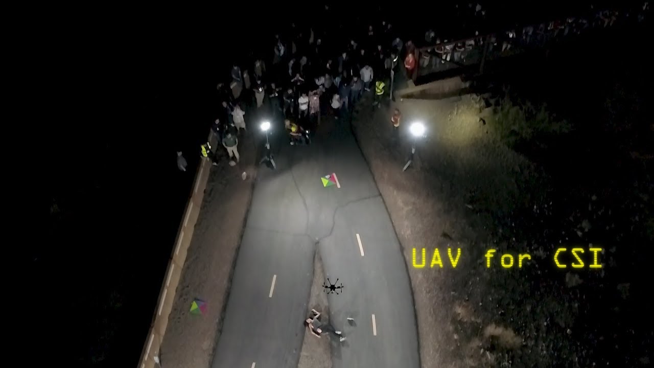
UAV mapping for Crime Scene InvestigationFOXFURYLED6,744 views | 50 | February 20 2019 21:52:27 (2 comments)[ Read more … ]
Sundance Media Group along with FoxFury Lighting Solutions, Pix4D, and Autel Robotics hosted a nighttime drone crime scene investigation demonstration in Henderson, Nevada. Recreating a murder scene at a local equestrian park, the demonstration sought to use drones to capture forensic evidence at the scene in the dark and map it in 2D and 3D for law enforcement use.
Sundance Media Group crew worked to show what would happen if law enforcement was discovering the murder scene and mapping it for the first time.
A model, outfitted with moulage, laid out as a murder victim. FoxFury Lighting Solutions provided four Nomad T56 Scene Lights to illuminate the surrounding area to aid with photo and video capture. These lights offer 95 CRI 5600K daylight balanced light allowing accurate color representations in the photos and video collected, which is extremely important when examining the scene at a later date. Other scene lights were positioned around the park for attendee safety and location marking.
Two drone launch pads were positioned at one end of the scene, one holding an Autel Evo, the other holding a Yuneec H520. The Autel Evo flew for 30 minutes, manually capturing 60 frames per second of 4k resolutions images as well as recording video up to 100mbps. This was the first time Autel showcased their new LiveDeck ™ technology, allowing the aircraft footage to be seen LIVE at the Sundance Media Group A.V.O.C. (Aerial Vehicle Operations Center). Once the data was captured, it was imported into Pix4D Mapping software where it verified the images and began to compile maps and models of the scene that were available for attendees to view on a large monitor within a few minutes.
The goal of this demonstration was to show attendees how this combination of portable lighting, drone hardware, and mapping software can significantly reduce field and surveying time for law enforcement officials while increasing the accuracy of the investigation. There is also a safety benefit as officials can evaluate a scene from a safe distance rather than putting themselves in harm’s way.
Due to an increased demand in this type of data gathering, similar demonstrations and workshops will be offered throughout the year. Information will be posted through Sundance Media Group and FoxFury Lighting Solutions as it becomes available.
http://www.sundancemediagroup.com/
https://www.foxfury.com/
https://www.pix4d.com/
http://us.yuneec.com/
https://auteldrones.com/
https://www.westwindcomputerproducts.com/uas
Check out Urban Prepper’s more in depth review of the event at https://www.youtube.com/watch?v=9N7-rTo0M38&t=192s
Advertisement
From Shallow Graves to Recreating Crime Scenes – Drone World PodcastCoptrz107 views | 3 | February 18 2022 16:06:28 (0 comments)[ Read more … ]
Welcome to Drone World, the podcast by COPTRZ! In this episode Sam Denniff & Tom Garnett join us to discuss some of the best stories coming out of January from the Public Safety sector. They also give some great insight into the direction drone usage is heading in for Police, Fire & Search and Rescue teams, as the technology becomes more widely adopted and the standard of pilots increase.
Tom & Sam explains how LiDAR could be used to help police assess the shallow graves, natural disasters and map/recreate crime scenes.
Sam says “Maps and models can be used as evidence now […] What we’re seeing is scans of massive areas of ground and noticing that certain areas look disturbed. For example for shallow graves or areas where evidence has been buried, traditionally you’d have officers walking hand in hand across a field, and spend a lot of money on overtime for those officers. Now you can use a drone and complete the survey in a fraction of the time.”
Website: www.coptrz.com Like us on Facebook: https://www.facebook.com/coptrz Follow us on Instagram: https://www.instagram.com/coptrz/?hl=en Follow us on Twitter: https://twitter.com/Coptrz
Advertisement
Drone lights to document night crime scenes & limitations for Photogrammetry | 3D Forensics | CSI3D Forensics366 views | 1 | March 3 2021 22:00:25 (0 comments)[ Read more … ]
Be informed as soon as we open registrations for our next Photogrammetry course. Pre-register at https://www.ai2-3d.com/photogrammetry
In this video, Eugene Liscio from ai2- 3D talks with Antonio Cugini about the use of drone lights to document night crime scenes and its limitations for Photogrammetry. . Antonio spent the last 7 years learning how UAVs, software and camera tech are changing the ways that first responders go about their work. He is especially interested in night-time and low light applications including tactical missions, post disaster searches and reconstruction of crime scenes and traffic accidents. He also worked on a resource to visualize forensic evidence. . Are you into Photogrammetry, Reality Capture and 3D models? Watch these other videos for more tips!
Is it possible to create quality 3D models of small objects ? | Photogrammetry | https://youtu.be/wp8pD4KTKzE
5 Common Mistakes when photographing for photogrammetry https://youtu.be/SzobKDdghGo
Can I use video to create 3D models? https://youtu.be/kT9BTdaTFPU
Creating 3D model of footwear impressions https://youtu.be/miIq-oid_CM
How to create 3D Models from Planar Surfaces ? | Photogrammetry https://youtu.be/B4EyvAWvKS8 . Still haven’t subscribed to ForensicAnimations on YouTube? ►► https://www.youtube.com/user/Forensic… . Follow us on Instagram @ai2_3d Follow us on Linkedin https://www.linkedin.com/company/ai2_3d . #forensicscience #forensics #forensicfiles #forensic #photogrammetry #3dmodeling #vr #crimesceneinvestigator #csi #laserscanner #laserscanning #realitycapture
Advertisement
Using UAS Technology in Collision and Crime Scene Reconstruction – Award Acceptance VideoWashington State Patrol739 views | 2 | October 17 2019 15:42:07 (0 comments)[ Read more … ]
The National Association of State Chief Information Officers (NASCIO) has announced that the Washington State Patrol’s project, Using UAS Technology in Collision and Crime Scene Reconstruction, has been selected as a NASCIO 2019 State Information Technology (IT) Recognition Awards recipient in the Emerging and Innovative Technologies category. “The Washington State Patrol’s use of Unmanned Aerial Systems has resulted in a significant reduction in road closure time and congestion associated with accident investigations, greatly improved investigative forensic documentation, and improved officer safety as investigations are conducted from the air rather than in the congested roadways”, according to Tom Wallace, Washington State Patrol’s Chief Technology Officer. Given annually to honor innovation and excellence in the use of IT in state government, the NASCIO Awards Committee selected 10 award recipients from over 130 award nominations nationwide.
Advertisement
About the Author
Patryk Alexander is an associate copy editor at 4kVideoDrones.com, where he sharpens articles and helps keep the website's content clean and error-free. With a background in creative writing, Patryk brings a unique perspective to his editing that helps make 4kVideoDrones.com's content engaging and informative. When he's not editing or writing, Patryk enjoys spending time with his family and exploring the great outdoors.