Drone Inspections: Revolutionizing Utility ROWs 🚁
The hum of a multi-rotor drone slicing through the air – it’s a sound becoming increasingly familiar to those managing utility right-of-ways (ROWs). For years, inspecting these vital corridors has been a labor-intensive process, often involving challenging terrain and potential hazards. But as a seasoned drone pilot and instructor, I’ve witnessed firsthand the transformative power of unmanned aerial vehicles (UAVs) in this sector. The videos highlighted below offer compelling glimpses into how drone technology is not just improving, but revolutionizing utility ROW inspections, enhancing efficiency, safety, and data accuracy. They underscore a pivotal shift: we’re moving from boots-on-the-ground alone to a collaborative approach where aerial intelligence complements and enhances traditional methods. Curious how these aerial eyes are changing the game? Let’s explore the key insights.
Key Takeaways from Drone Inspection Videos
-
Synergistic Approach: The "Utility Right of Way Inspections: Drones Part 2" video from Davey emphasizes a crucial point: drones aren’t replacing experienced professionals, they’re empowering them. The video highlights the powerful synergy created when drone-collected data is combined with the expert analysis of ground personnel. This blended approach ensures comprehensive and accurate insights, leveraging the strengths of both methods. Imagine the perspective shift – instead of a lineman painstakingly traversing miles of dense foliage, they can now direct their expertise to analyzing high-resolution imagery pinpointed by a drone, focusing their efforts where they’re most needed.
-
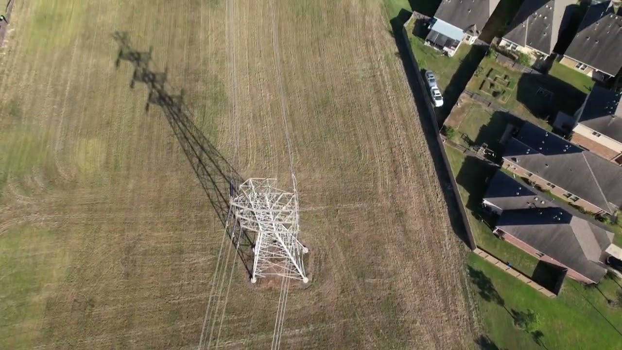
Enhanced Accessibility and Convenience: As highlighted in "Utility Right of Way Inspections: Drones Part 1," the sheer accessibility offered by drones is a game-changer. Think about it: previously inaccessible areas due to steep inclines, dense vegetation, or water crossings can now be visually inspected with ease and speed. This translates directly to reduced inspection times and costs, allowing utilities to cover more ground, more frequently. The convenience factor also extends to rapid deployment – a drone can be airborne and capturing data in minutes, a stark contrast to mobilizing ground crews for complex terrain.
-
Data-Driven Insights: Both Davey videos underscore the value of the data collected by drones. High-resolution imagery, thermal scans, and LiDAR data provide a level of detail previously unattainable through traditional methods. This granular data enables proactive identification of potential issues, such as encroaching vegetation, damaged insulators, or corrosion, allowing for preventative maintenance and minimizing the risk of outages. It’s about moving from reactive repairs to predictive maintenance, driven by accurate, timely aerial intelligence.
-
The "First Pass" Perspective: The "First Pass of Utility Line Inspection" video, while a brief glimpse, offers a practical demonstration of initial data capture. While the description notes the absence of zoom on this initial flight, it vividly illustrates the speed and coverage a drone can achieve. Imagine the visual – the drone, a nimble scout, swiftly traversing the ROW, capturing a broad overview. This initial sweep allows for rapid identification of areas requiring closer scrutiny, optimizing subsequent, more detailed inspections. It’s about efficient triage of inspection efforts.
The Evolution of Utility Inspections: From Binoculars to Bytes
The integration of drones into utility ROW inspections isn’t just a technological upgrade; it’s a fundamental shift in how we approach asset management. We’re moving from relying solely on human observation, often limited by vantage points and physical constraints, to a system augmented by aerial platforms equipped with sophisticated sensors. This evolution allows for a more objective and comprehensive assessment of infrastructure health. Think of the traditional method: a lineman scanning power lines with binoculars, a vital but inherently limited perspective. Now, envision a drone capturing multiple angles, including orthomosaic views and detailed close-ups, providing a holistic picture that the human eye alone simply cannot achieve. This data richness empowers utilities to make more informed decisions, prioritize maintenance tasks effectively, and ultimately ensure a more reliable energy grid.
Looking Ahead: The Future is Autonomous and Intelligent
While the current state of drone inspections is already transformative, the future holds even greater potential. We’re on the cusp of seeing more sophisticated autonomous flight capabilities, where drones can navigate pre-programmed routes and identify anomalies using onboard AI. Imagine drones autonomously patrolling vast stretches of ROWs, instantly flagging potential issues for human review. Furthermore, the integration of machine learning algorithms will enable even more advanced data analysis, predicting potential failures based on subtle indicators detected by the drones. The future of utility ROW inspections is one of increasing autonomy, intelligence, and proactive risk management, all powered by the versatile capabilities of drone technology.
Taking Utility Inspections to New Heights
The videos highlighted here offer a compelling snapshot of the drone revolution unfolding within utility right-of-way inspections. They underscore the tangible benefits – increased efficiency, enhanced safety, and richer data – that drones bring to the table. Ready to explore how integrating drone technology can elevate your utility inspection program? Scroll down to watch the video highlights and witness firsthand the power of aerial intelligence in action. The future of utility ROW management is airborne, and the insights are just a click away.
Find the selected videos below