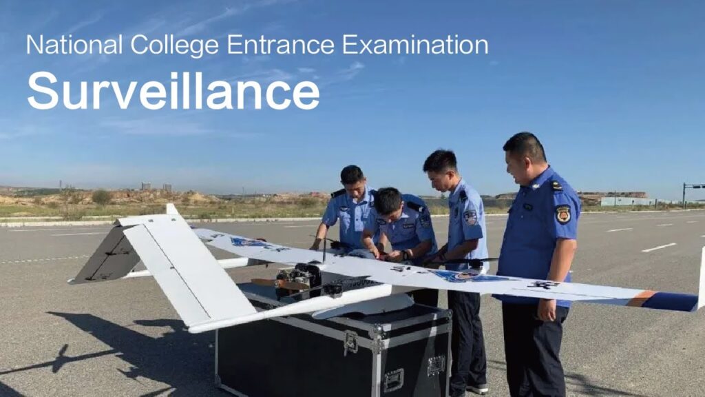
JOUAV CW-30 Drone: Mapping Disasters & Power Lines 🌎✈️
Senior Associate Copy Editor
JOUAV CW-30: Unleash VTOL power for disaster relief & infra-inspection! Click to witness the future.
JOUAV CW-30: Unleashing the Power of Vertical Takeoff for Disaster Relief and Infrastructure Inspection
From post-rainstorm devastation to the intricate web of power lines crisscrossing our world, the JOUAV CW-30 VTOL (Vertical Take-Off and Landing) drone is emerging as a critical tool. These YouTube videos showcase the incredible versatility of this hybrid fixed-wing platform, revealing its ability to capture high-resolution LiDAR data, navigate challenging environments, and provide crucial information for a range of applications. We’ll dive into the specifics of how this powerful UAV is revolutionizing disaster response and infrastructure management, exploring real-world deployments and examining the tech that makes it all possible. Get ready to experience the future of aerial data acquisition.
CW-30 in Action: Key Takeaways
Rapid Disaster Response: The CW-30 can be quickly deployed to map areas affected by natural disasters like rainstorms, providing vital data for rescue and recovery efforts. Imagine the ability to assess damage, pinpoint stranded individuals, and plan relief routes with unparalleled speed and accuracy.
Power Line Inspection Redefined: Equipped with LiDAR, the CW-30 offers a highly efficient and detailed inspection process for power lines. This allows utilities to detect faults, monitor infrastructure health, and prevent outages before they impact communities. Forget tedious manual inspections; the CW-30 provides a comprehensive, three-dimensional view.
Extreme Environment Performance: With self-heating batteries and airspeed tubes, the CW-30 can operate in challenging weather conditions, from freezing temperatures to strong winds and light rain. This robustness ensures mission success in critical situations and expands the operational window for essential tasks.
Long-Range Capability: The CW-30 boasts impressive endurance, with flight times of up to 8 hours and a communication range reaching 200km. This extended reach is invaluable for large-area surveillance, maritime monitoring, and other long-distance missions. Think coastal patrols, search and rescue operations, and even wildlife surveys – all within the CW-30’s capabilities.
Versatile Payload Options: From multi-camera arrays for detailed imaging to LiDAR systems for 3D mapping and dual-sensor EO/IR cameras for surveillance, the CW-30’s adaptable payload capacity opens up a world of possibilities for diverse applications.
Beyond the Horizon: The Expanding Role of the CW-30
The demonstrated success of the CW-30 in disaster relief and power line inspection hints at a future where VTOL drones play an even larger role in various sectors. As LiDAR technology continues to advance, and as AI-powered data analysis becomes more sophisticated, we can expect to see the CW-30 become an even more indispensable tool for infrastructure management, environmental monitoring, and public safety. Imagine automated power line inspections identifying potential faults in real-time, or post-disaster maps generated within hours, guiding emergency response teams with precision. The possibilities are vast and evolving rapidly.
Ready for Takeoff?
This is just the beginning of exploring the incredible potential of the JOUAV CW-30. Scroll down to watch curated highlights from these insightful YouTube videos and experience the capabilities of this cutting-edge drone for yourself. You won’t want to miss the in-flight footage!
Scroll down to explore the videos
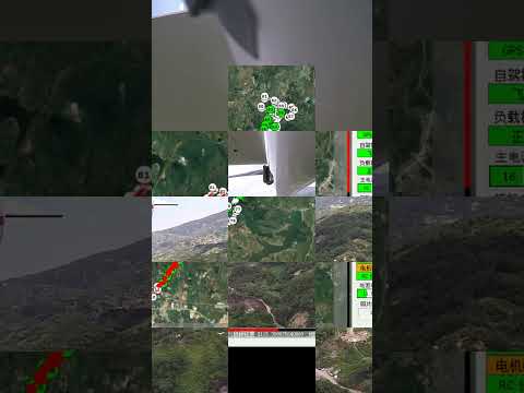
Efficient Power Line Inspection Process with JOUAV CW-30 LiDAR DroneJOUAV666 views | 0 | November 1 2024 02:55:08 (0 comments)[ Read more … ]
Join us as we explore how the JOUAV CW-30 drone, equipped with high-resolution LiDAR sensor, enhances power line inspection processes. This video covers phases of a typical CW-30 inspection mission, from takeoff to real-time flight monitoring and post-data analysis.
Designed for rapid deployment and extreme accuracy, the CW-30 empowers utilities to detect faults, monitor infrastructure health, and ensure energy reliability.
HOW JOUAV CW-30E Drone Used for Mapping Post-Rainstorm Disaster AreasJOUAV9,514 views | 0 | July 11 2024 02:51:22 (0 comments)[ Read more … ]
Join us as we deployed the JOUAV CW-30 drone to map disaster-affected areas after a severe rainstorm, capturing crucial data for disaster relief and recovery efforts. Witness the cutting-edge technology and precision of the CW-30 in this vital mission.
#uav #drone #mapping
Meet JOUAV CW-30E VTOL Long-Range UAV SystemJOUAV5,828 views | 62 | December 22 2023 07:32:45 (5 comments)[ Read more … ]
The JOUAV CW-30E is the perfect choice for professionals looking for a reliable VTOL drone that can handle long-range and extreme environments missions.
Boasting self-heating airspeed tube and battery, the CW-30E is designed to withstand rain(≤10mm/24h)and wind(13.9-17.1m/s), while its temperature range from -20°C to 55°C enables users to carry out their operations in the most extreme locations.
Furthermore, its payload capacity is up to 8 kg, while the endurance can reach up to 8 hours, and the effective communication link can extend up to 200 km. This makes it perfect for large-area and long-distance missions such as surveillance, maritime monitoring, public security, etc.
Gain more insight into the CW-30E’s top features: https://www.jouav.com/products/cw-40.html
JOUAV + Phoenix LiDAR Systems TerraHawk CW-30Phoenix LiDAR Systems16,754 views | 130 | September 25 2017 22:32:39 (4 comments)[ Read more … ]
The TerraHawk CW-30 is a hybrid VTOL / fixed-wing UAV with
an integrated Phoenix Ranger-LR-T LiDAR mapping payload.
Hybrid VTOL / fixed-wing technology offers an innovative and
logistically simple solution to the problem of vertical takeoff and
landing: it combines the vertical takeoff and landing (VTOL)
capabilities of a multirotor aircraft and the efficiency, speed,
and range of a normal fixed-wing aircraft. Combined with the
Phoenix Ranger-LR-T payload, the TerraHawk CW-30 provides
both ortho-imagery as well as high density LiDAR point clouds.
CW-30 6 hrs long range VTOL Drone Surveillance SolutionJOUAV15,005 views | 144 | May 25 2017 09:42:18 (17 comments)[ Read more … ]
CW-30 features 3-6 kg payload capability for different kind payload ,such as multi-camera , Lidar system for surveying 3D modelling , dual sensor EO/IR Video Camera fur surveillance inspection.
JOUAV CW-30E UAV: Smooth Takeoff & Landing for A Maritime MissionJOUAV1,755 views | 0 | September 24 2024 06:24:37 (0 comments)[ Read more … ]
Experience the mobile takeoff and landing capacity of the JOUAV CW-30E UAV as it takes on a maritime mission in windy conditions! With wind speeds at 12.8 m/s, the CW-30E maintains steady performance, cruising at 25 m/s in the air. Its capabilities ensure reliable performance, even in challenging environments, making it the go-to solution for critical maritime tasks such as sea animal monitoring, personnel rescue, and environmental assessments.
#JOUAV #drone #uav
About the Author
Patryk Alexander is an associate copy editor at 4kVideoDrones.com, where he sharpens articles and helps keep the website's content clean and error-free. With a background in creative writing, Patryk brings a unique perspective to his editing that helps make 4kVideoDrones.com's content engaging and informative. When he's not editing or writing, Patryk enjoys spending time with his family and exploring the great outdoors.