Unlock the Power of Aerial Insights: Digital Mapping with Drones
Creating digital maps with drones is no longer the exclusive domain of specialized firms. Today, advancements in drone technology and accessible software are democratizing aerial mapping, putting this powerful tool within reach of hobbyists and professionals alike. Imagine transforming raw drone imagery into accurate 2D maps, detailed 3D models, and insightful spatial data – all from a device you can control. These digital maps unlock a new perspective across diverse fields, from surveying land parcels and monitoring construction progress to creating detailed 3D models for visualization and analysis. The following video highlights offer a pilot’s-eye view into how you can take to the skies and generate your own digital maps.
Key Insights from Drone Mapping Experts
Any Drone Can Be a 3D Scanner: Don’t think you need top-of-the-line equipment. As highlighted in “Turn ANY Drone into a 3D SCANNER And Make 3D Models w/ Photogrammetry”, the principle of photogrammetry empowers even consumer-grade drones to capture data for 3D modeling. By strategically planning your flight paths using tools like Waypointmap and capturing overlapping images, you can transform standard aerial photos into impressive 3D representations. The visual precision offered by these models is remarkable – showcasing the detailed textures and forms captured from above.
Free Software Options Make Mapping Accessible: Cost can be a barrier, but videos like “Drone Photogrammetry Processing for FREE!” reveal the availability of robust, free cloud-based processing platforms like MapsMadeEasy. This is a game-changer for individuals and smaller operations, removing the need for expensive software licenses and powerful desktop computers. MapsMadeEasy simplifies the workflow, supporting imagery from a wide range of drones, and offering a compelling entry point to drone mapping without compromising on functionality.
Construction Industry Benefits from Drone Mapping Efficiency: The construction sector is rapidly adopting drone mapping for its practical benefits. “Drone Mapping for Construction: Complete Guide” underscores how orthomosaic maps generated by drones streamline construction workflows. These maps become vital communication tools, aiding in project planning, progress tracking, and stakeholder updates. The ability to quickly survey a site and generate a current, accurate map translates to improved efficiency and informed decision-making on dynamic construction sites.
Building a Drone Mapping Business is Achievable: For those looking to leverage drone mapping professionally, “How to build a SUCCESSFUL Drone Mapping business in 2023 – Drone Deploy” offers valuable business insights. The video emphasizes the growing demand for drone mapping services across various industries. Software platforms like DroneDeploy are not just mapping tools; they are integrated solutions designed to manage the entire business workflow, from flight planning and automated data capture to processing and client delivery. This end-to-end approach significantly lowers the barrier to entry for aspiring drone mapping entrepreneurs.
Open-Source Tools Offer Powerful Alternatives: For technically inclined users, “Using WebODM to Process Drone Imagery (RTK or GCP) & Perform an Accuracy Assessment with QGis Part 1” showcases the power of open-source solutions like WebODM. This video guides you through the process of installing and utilizing WebODM to process drone imagery, even incorporating Ground Control Points (GCPs) or RTK data for enhanced accuracy. Furthermore, it demonstrates how to conduct accuracy assessments using QGIS, a free and open-source GIS software, empowering users with complete control over their data processing pipeline.
Mastering Export and Data Utilization is Key: The true value of drone mapping extends beyond initial map creation. “Drone Mapping Guide | Part 4” from a series on RealityCapture, focuses on the critical step of exporting data in various formats. Learning to export point clouds, orthomosaics, contours, and other data products unlocks the potential to integrate drone-derived insights with other industry-standard software like CloudCompare and QGIS. This interoperability is essential for advanced analysis, collaboration, and delivering actionable outputs.
The Democratization of Aerial Cartography
The consistent message across these videos is clear: drone mapping is becoming increasingly accessible. The advancements in user-friendly software, coupled with the versatility of modern drones, are empowering a broader audience to generate high-quality digital maps. We’re observing a trend towards simplified workflows, greater software accessibility (including free and open-source options), and expanding applications across diverse industries. Looking ahead, we can anticipate further integration of AI and automation within drone mapping processes, leading to even greater efficiency and accuracy for users at all levels of expertise.
Take Flight and Map Your World
Drone mapping is a dynamic field, constantly evolving with technological advancements and expanding applications. These video insights provide a practical starting point, demonstrating that creating digital maps with drones is achievable for anyone willing to learn the fundamentals. Scroll down to explore the video highlights and take the first step in transforming your aerial perspectives into valuable digital realities.
View the curated videos below
Turn ANY Drone into a 3D SCANNER And Make 3D Models w/ PhotogrammetryJays Tech Vault31,615 views | 809 | June 4 2024 16:00:49 (51 comments)[ Read more … ]
Turn your drone into a 3d scanner. Create stunning 3d models with any consumer drone. Learn how to make reliable and accurate 3d models and maps with any consumer drone through a process called photogrammetry.
Models from this video: https://www.aerialmodel.com/Home/Viewer?id=241&token=61be705f-0100-4b86-a442-72102fa38c86 https://www.aerialmodel.com/Home/Viewer?id=238&token=a686d651-2ffc-41fc-bcca-fc85bfede566
Drone Photogrammetry Processing for FREE!Geospatial Tips172,271 views | 3,188 | March 31 2023 10:49:35 (120 comments)[ Read more … ]
Use your drone to perform drone mapping and photogrammetry, create maps, point clouds and 3D models for FREE with this MapsMadeEasy tutorial! It’s cloud based, so you don’t need a powerful computer either.
Maps Made Easy makes it so simple for anyone who owns a drone or UAV to use photogrammetry and create a map for free and then share it online! But not just DJI drones, their cloud processing app will process any drone images.
See how it compares to commercial offerings such as Agisoft Metashape and Pix4D.
Autel drones are supported as well in their flying app. It’s amazing what they offer free of charge.
Map Pilot Pro (https://dronesmadeeasy.com/map-pilot) supports all of these drones:
Mini 2 Air 2 Air 2S Air Mavic 3 Enterprise (on M3E remote) Mavic 3 Multispectral (on M3M remote) Mavic 2 (Pro, Zoom, and Enterprise – No SMART CONTROLLER support) Mavic 2 Enterprise Advanced Mavic Pro Phantom 4 Phantom 4 Pro * (v2 included) Phantom 4 Advanced Phantom 4 RTK Phantom 3 Professional Phantom 3 Advanced Phantom 3 Standard Inspire 1 Inspire 1 Pro Inspire 2 M30 (on RC Pro Plus remote) M30T(on RC Pro Plus remote) Matrice 100 (M100) Matrice 200 (M200, including V2) Matrice 210 (M210, including V2) Matrice 210 RTK (M210RTK) Matrice 600 (M600) Matrice 600P (M600P) Autel EVOII ( no “V2” support)
*This is not a sponsored video*
How you can support my work ————————————————-
Book a consulting session with me: https://tinyurl.com/4rz33j2d
Support my work on Buy Me a Coffee: https://buymeacoffee.com/geospatialtips
Hire me on Upwork: https://www.upwork.com/freelancers/~016ba4a9bb38699a0e
00:00 – Looking for a Free Alternative? 00:17 – Map Pilot Pro Image Capture 01:20 – Maps Made Easy Data Processing 09:40 – Global Mapper Additional Processing
Drone Mapping for Construction: Complete GuideThe Drone Life326,518 views | 9,165 | November 17 2021 22:43:05 (170 comments)[ Read more … ]
Claim Your FREE GUIDEBOOK to Using Drones in Construction 👇 https://bit.ly/42MY2b9
In this video, you will learn what are orthomosaic drone maps, the benefits of drone mapping in construction, and how to map a construction site using a drone.
So if you are a construction company looking to get started in drone mapping or if you’re a pilot looking to expand your service offerings, this video is for you.
We’ve been producing 2D orthomosaic maps at this 500,000 Sq Ft warehouse job site. These maps are greatly beneficial for improving communication, planning construction phases, keeping records, monitoring progress, and sharing with project stakeholders.
Using a Mavic 2 Pro drone and mapping software Dronedeploy, we’re going to share our mapping workflows, best practices, and tips!
►Resources ➡️ Start Your FREE 14-Day DroneDeploy Trial Now – http://bit.ly/3EPADdN
►Our Must-Have Drone Equipment Checklist ✅ Budget Friendly Ground Control Points (GCPs) – http://bit.ly/3nAT2pH ✅ Most Reliable SD Card for Drone Mapping – http://bit.ly/3lZOhWn ✅ Heavy Duty Landing Pad – http://bit.ly/3zt1hXA ✅ Collapsable Orange Safety Cones – http://bit.ly/40Tr2fp ✅ OSHA Certified Safety Vest -http://bit.ly/3KsycSt ✅ Wind Speed Anemometer Gauge – http://bit.ly/3ZCaYO5 ✅ Best Flight Planning Tablet – http://bit.ly/40Dci4q ✅ Handheld VHF Airband Transceiver – http://bit.ly/40AyLPP
►About The Drone Life The Drone Life is an industry-leading UAS service provider that provides turnkey aerial data solutions nationwide. We proudly specialize in the industrial, environmental, renewable, and construction industries. Our team consists of highly experienced, dependable, and licensed drone professionals that are committed to safety, quality, and customer success.
►Chapters 0:00 Intro 0:34 What are orthomosaic drone maps? 1:21 Benefits of drone mapping 3:58 Flight planning 14:28 Flying the site 18:49 Conclusion
#dronemapping #dronesinconstruction #construction
How to build a SUCCESSFUL Drone Mapping business in 2023 – Drone DeployDylan Gorman106,389 views | 3,807 | March 7 2022 17:00:20 (434 comments)[ Read more … ]
Drone mapping is not so much a commodity anymore as much as it used to be. Drones are being used for all kinds of applications, from inspections to search & rescue, construction progress monitoring, and utility asset management. Drones are becoming an intricate part of everyday operations in so many industries. This video goes over the basics of how to build a drone-based mapping business with an easy-to-use software called Drone Deploy that will take care of every aspect of the business!
Looking to learn more about drone photogrammetry? Check out our online course: https://www.pilotbyte.com/drone-mapping-mastery
Check out Drone Deploy here: http://bit.ly/3XLmff5
►UPDATE 7/19/22 Drone Deploy just added support for the DJI Mavic Air 2s. You are now able to fly automated flight missions with the Drone Deploy application with supported IOS devices. Pick up the Air 2s here from Amazon for $999 https://amzn.to/3PkffBr
► Here are a few drones that I recommend for Drone Photogrammetry 1) DJI Phantom 4 Pro V2.0 (This is the best mapping drone to date, do NOT get the “+” version as it is not supported by mapping software at all): https://amzn.to/3rMUUe2 2) DJI Mavic 2 Pro (This is the drone that I started mapping with, still a great option!): https://amzn.to/3LgeDLc 3) DJI Air 2 (This just got supported and is the BEST entry drone to get into Drone Photogrammetry, UNDER $800 for Fly More Bundle): https://amzn.to/3KeDDRs
This video is sponsored by Drone Deploy. For new users of DroneDeploy, get your 14-day FREE trial sign up with the link below and reach out to matt.lyon@dronedeploy.com and let him know Dylan sent you.
Signup for Drone Deploy trial: https://www.dronedeploy.com/signup-v2.html – ► Subscribe to my channel here: https://www.youtube.com/channel/UCcv7q4TeTBlso7Mvc0aIAAA? – My Camera Equipment! Canon R5: https://amzn.to/3yTgYWA Canon 24-70 2.8L: https://amzn.to/2S2KVCK Rode Microphone: https://amzn.to/3pfokiM Drone: https://amzn.to/3c60Sz9 __ Follow me online!
LinkedIn: https://www.linkedin.com/in/dylan-g-099961101 Instagram: https://www.instagram.com/dylang_1 – #dronemapping #dronedeploy #dronemappingsoftware #dronedeploy #dronebusiness – Chapters 00:00 Intro 00:57 What is Drone Mapping? 01:39 Drone Deploy Sponsor Spot 02:15 Why is Drone Mapping useful? 03:03 Real-World Case Study. 04:23 What equipment is needed? 05:31 Set up an automated flight in the field! 09:24 pre-flight inspections 10:17 Drone Deploy automated flight 11:08 Data upload/ processing 12:02 Processed data analysis/ Drone Deploy’s cloud tools. 13:22 3D Drone model 14:55 How to build a successful business off of Drone Deploy? 15:35 What industries can I use drone mapping in? 17:01 Drone Deploy Sponsor 19:07 Outro
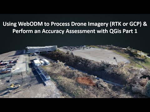
Using WebODM to Process Drone Imagery (RTK or GCP) & Perform an Accuracy Assessment with QGis Part 1Nathan J.B.27,430 views | 511 | December 23 2021 02:39:45 (35 comments)[ Read more … ]
This is part 1 of a two part series using WebODM and performing an accuracy assessment using the outputs from WebODM in QGis. Part 1 covers: 1. Installing WebODM 2. Preparing imagery and looking at exif data 3. Launching WebODM 4. Making a new project and uploading imagery 5. Selecting parameters and running WebODM 6. Georeferencing with GCP data 7. Downloading products
Drone Mapping Guide | Part 4Capturing Reality12,589 views | 192 | February 1 2022 15:26:15 (43 comments)[ Read more … ]
This is the fourth and last part of our tutorial series covering drone mapping in RealityCapture. In this one, we’ll go over exporting our creations and using them in third-party applications like CloudCompare and QGIS.
Part 1: https://youtu.be/jxOCAr_33zA Part 2: https://youtu.be/xN_E3DnF_Gw Part 3: https://youtu.be/Ag451qyOQHo
Download RealityCapture: http://bit.ly/2sotr7h Try it yourself with free sample datasets: https://bit.ly/3cRBfQp
Follow us on: Instagram https://www.instagram.com/capturingrealitycom/ LinkedIn https://www.linkedin.com/company/capturing-reality/ Facebook https://www.facebook.com/CapturingRealityCom/ Twitter https://twitter.com/RealityCapture_
About the Author
Patryk Alexander is an associate copy editor at 4kVideoDrones.com, where he sharpens articles and helps keep the website's content clean and error-free. With a background in creative writing, Patryk brings a unique perspective to his editing that helps make 4kVideoDrones.com's content engaging and informative. When he's not editing or writing, Patryk enjoys spending time with his family and exploring the great outdoors.