Unlocking Aerial Potential: DJI Pilot & GS Pro for Advanced Drone Operations
The drone industry is rapidly evolving, and at the heart of this transformation are powerful software tools that redefine mission capabilities. For professionals seeking to maximize efficiency and precision in their aerial operations, DJI Pilot and GS Pro stand out as game-changers. These applications aren’t just about flying drones; they’re about orchestrating complex missions, managing critical data, and unlocking new levels of operational effectiveness. From automated flight paths to streamlined data workflows, DJI Pilot and GS Pro are revolutionizing how we approach drone missions, pushing the boundaries of what’s achievable in the sky. Let’s explore key insights from recent video discussions that highlight the transformative power of these platforms.
Key Insights from Leading Drone Professionals
Automated Precision Flight Missions: DJI GS Pro excels at simplifying complex flight operations through automation. As highlighted in "DJI Ground Station Pro | Mission-Critical Flight Simplified," the app enables users to conduct automated, precise flight missions with ease. This automation is crucial for consistent data acquisition in applications like mapping and inspections, reducing human error and ensuring repeatable results.
Enhanced Data Management and Collaboration: Modern drone operations generate vast amounts of data. GS Pro addresses this challenge head-on by offering secure cloud backup for flight data, as mentioned in "DJI Ground Station Pro | Mission-Critical Flight Simplified." Furthermore, it optimizes workflows by providing access to historical mission data, aircraft logs, and facilitates team collaboration through features that allow sharing, editing, and duplicating mission parameters. This centralized data management is vital for maintaining data integrity and improving operational efficiency across teams.
In-Flight Monitoring for Real-Time Awareness: Situational awareness is paramount during drone missions. "DJI In-Flight Monitoring" emphasizes the importance of real-time data displayed on the controller. Whether using DJI Pilot 2 on newer platforms like the Mavic 3 Enterprise or GS Pro on older models, pilots have access to critical information during topographic mapping missions. This immediate feedback loop allows for on-the-fly adjustments, ensuring mission success and data quality.
GS Pro for Mapping and Photogrammetry: The Spanish-language video, "DJI GS Pro la mejor app para mapeo de dji para phantom , Mavic con los iPad," reinforces GS Pro’s reputation as a top application for mapping, particularly with Phantom and Mavic series drones using iPads. This underscores GS Pro’s accessibility and broad compatibility, making advanced mapping capabilities available to a wide range of users and drone platforms.
DJI Pilot vs. GS Pro: Choosing the Right Tool for the Job: "Is the Mavic 2 Enterprise Advanced A Good Drone For Solar PV Inspections?" brings to light the nuanced differences between DJI Pilot and GS Pro. The Mavic 2 Enterprise Advanced, for example, was initially only compatible with DJI Pilot, not GS Pro. This highlights the importance of understanding platform compatibility and choosing the right software for specific drone models and mission objectives. The video implicitly suggests that while DJI Pilot is versatile, GS Pro often provides more advanced features for automated missions, especially in sectors like solar inspections.
KML File Integration for Streamlined Mission Planning:Efficient mission planning is critical for maximizing flight time and data quality. "How to Create a .KML file for DJI Pilot" demonstrates how to leverage KML files for importing pre-defined flight boundaries and paths into DJI Pilot. This capability significantly streamlines the mission planning process, allowing pilots to quickly and accurately define complex flight areas based on geographic data from tools like Google Earth. The video’s popularity (high view count) indicates a strong user interest in optimizing mission planning workflows through KML integration.
Automated Flight Planning for Specific Applications (Agriculture): The Portuguese video, "#EP1 – Planejamento de voo automatizado para mapeamento fotogram trico utilizando DJI GS PRO," specifically focuses on automated flight planning with GS Pro for photogrammetric mapping in agriculture. This video, part of a web series, highlights the application of GS Pro in specialized sectors like agriculture, demonstrating its capability to automate complex mapping missions for precision agriculture and related applications. The high engagement (likes and comments) suggests strong interest in GS Pro’s application in the agricultural drone space.
The Trajectory of Drone Mission Software
Looking at these insights, it’s clear that DJI Pilot and GS Pro are not static tools but are continuously evolving to meet the growing demands of the drone industry. We can anticipate further advancements in areas like:
Enhanced Cloud Integration: Deeper integration with cloud platforms for real-time data processing, analytics, and remote operations management.
AI-Powered Automation: Incorporation of artificial intelligence to further automate mission planning, in-flight decision-making, and data analysis.
Expanded Platform Compatibility: Continued efforts to ensure compatibility with a wider range of DJI drones and potentially third-party platforms, broadening the accessibility of advanced mission planning and execution tools.
Industry-Specific Solutions: Development of more tailored features and workflows within DJI Pilot and GS Pro to address the unique needs of specific industries like agriculture, construction, energy, and public safety.
Elevate Your Drone Missions Today
DJI Pilot and GS Pro are powerful allies in the quest for efficient, precise, and data-rich drone operations. They represent a significant leap forward in mission planning and execution, empowering drone professionals to achieve more in less time, with greater accuracy and safety. Scroll down to explore the video highlights and see these tools in action, and consider how DJI Pilot and GS Pro can revolutionize your drone missions.
View the highlighted videos below
DJI Ground Station Pro | Mission-Critical Flight SimplifiedDronehub Africa16 views | 1 | November 20 2024 14:53:43 (0 comments)[ Read more … ]
Take your drone operations to the next level with DJI Ground Station Pro (DJI GS Pro), the ultimate iPad app for automated flight missions and seamless data management.
With DJI GS Pro, you can: ✅ Conduct automated, precise flight missions effortlessly. ✅ Securely back up flight data on the cloud for enhanced reliability and accuracy. ✅ Optimize workflows with access to historical mission data, aircraft logs, and team member contributions. ✅ Collaborate like never before—share, edit, and duplicate mission parameters across your project team with ease.
Whether you’re managing a drone fleet or streamlining your operations, DJI GS Pro provides the tools you need to run an efficient and effective drone program.
Ready to revolutionize your drone operations? Explore DJI GS Pro today!
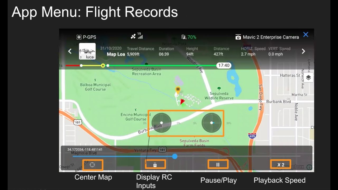
DJI In-Flight MonitoringQuantum Land Design400 views | 8 | May 5 2023 18:23:51 (0 comments)[ Read more … ]
A quick walk-through explaining the information available on the controller during a topographic mapping mission.
We are showing DJI Pilot 2 on a Mavic 3 Enterprise (M3E) here. Similar information will be available in Ground Station Pro for older DJI drones with mapping capabilities.
Free machine control and drone data resources – www.quantumlanddesign.com/education
Machine Control Models – www.quantumlanddesign.com/machine-control-data-prep
Email sales@avqld.com with questions.
Advertisement
DJI GS Pro la mejor app para mapeo de dji para phantom , Mavic con los iPadcastor_tech1,407 views | 46 | April 1 2020 01:30:10 (21 comments)[ Read more … ]
en esta ocasion os presento la apps gratis para mapeo de dji GS Pro para iPad Otras Redes sociales Instagram http://bit.ly/2BU4r8N Facebook http://bit.ly/334QfWs Podcast http://bit.ly/2PoVJaQ Links de descuentos DJI DJI Osmo action: https://click.dji.com/AEYDDmyp9HdeNtMGAq4oKw?pm=link Drones DJI zona EU :https://click.dji.com/AO64ucbMP3Tu27bNAR7FTg?pm=link Drones DJI zona NA : https://click.dji.com/AFrn0sdmAO4FrBzym_Wy5A?pm=link DJI Osmo Pocket :https://click.dji.com/ANw333dm3pUIRBws4Pha5A?pm=link My Devices (Mi Equipo) Cameras Nikon coolpix B700 : https://amzn.to/2S6SZ4z dji osmo pocket : https://amzn.to/2Tv2Uxn (no) Kit de Expansi n : https://amzn.to/2t3pMbB (no) filtros nd polarizados : https://amzn.to/2DaaC95 Camera VR 360 Samsung 360 https://amzn.to/2D5RwB4
Is the Mavic 2 Enterprise Advanced A Good Drone For Solar PV Inspections?Skye Link627 views | 14 | February 8 2022 19:23:47 (5 comments)[ Read more … ]
Finally a lower cost radiometric 640 resolution DJI drone is available – the M2EA! But is the Mavic 2 Enterprise Advanced a good drone for aerial thermography solar inspections?
In this video, we review the pros and cons of using the DJI Mavic 2 enterprise Advanced for solar pv inspections, especially if you are flying Raptor Maps style inspections. Also discussed are the differences of using DJI Pilot rather than DJI Ground Station Pro, as the Mavic 2 Enterprise Advanced is not yet compatible with GS Pro, only DJI Pilot.
Something else not noted in the video is cost considerations/budget, depending on your budget a M2EA may be the best option given it the most affordable but strictly for optimizing your solar inspection data collection workflow there are other platforms out there that allow you increased production capability and more automated workflow. We hope you find this video helpful.
Are you a drone pilot interested in joining Skye Link’s drone pilot network? Visit https://skyelink.org/register to create an account and get flying today!
Advertisement
#EP1 – Planejamento de voo automatizado para mapeamento fotogram trico utilizando DJI GS PRODrone Experts5,600 views | 317 | December 10 2022 23:05:10 (26 comments)[ Read more … ]
Planejamento de voo automatizado para mapeamento fotogram trico utilizando DJI GS PRO
Inscreva-se no canal para receber todas novidades.
Chegou a hora de voc dominar a tecnologia mais vers til do Agroneg cio e se torna um profissional diferenciado em um dos setores que mais crescem no BRASIL. Uma webs rie online e gratuita que vai ensinar o passo-a-passo da utiliza o dos DRONES AGR COLAS de uma forma nunca antes vista. As aulas ser o disponibilizadas no canal Drone Experts e ministradas por Thamylon Dias, que Msc em Engenharia florestal, MBA em gest o de projetos, Especialista em Drones Agr colas, com mais de dez anos no setor. Como instrutor j treinou mais de 5mil alunos e vem ensinando como pessoas simples podem entrar, se destacar e ter sucessos no mercado de drones.
Para se inscrever muito simples, basta acessar o link a baixo: Inscreva-se: https://lp.droneexperts.com.br/
Ser o seis dias de muito conte do, nas aulas ser o reveladas t cnicas que podem te proporcionar um conhecimento que vai te deixar a frente de 90% das pessoas que trabalham com drones agr colas. Quem se inscrever ter acesso aos conte dos exclusivos: Primeiro dia: • Abertura da webs rie e boas vindas • Planejamento de voo automatizado para mapeamento fotogram trico • Execu o de voo automatizado para mapeamento fotogram trico Segundo dia: • M todos de fechamento de mapas para pulveriza o • Execu o de plano de voo de pulveriza o Terceiro dia: • Processamento e fechamento de mapas de aplica o utilizando DJI TERRA Quarto dia: • Como baixar os mapas de aplica o para o RC (R dio Controle) • Acess rios importantes na aplica o agr cola, conhe a a import ncia do medidor de PH e do Termohig metro Quinto dia: • Calibra es necess rias para o bom funcionamento do drone agr cola • Execu o de voo inteligente de pulveriza o (aplica o localizada) • Gest o de frota e m tricas de aplica o dos drones agr colas Sexto dia 15/12: • SUPER LIVE AO VIVO • Tr s conte dos in ditos e exclusivos • Tira-d vidas • Fechamento da webs rie Se inscreva e participe! 🤝 Nossas redes sociais: Facebook:https://www.facebook.com/portalexpertsbr/ Instagram:https://www.instagram.com/portalexperts/ Site:https://www.portalexperts.com.br/ Grupo Vip: https://chat.whatsapp.com/KVDvL2uqLxWJA6wBKVkuii
How to Create a .KML file for DJI PilotGrant Hosticka37,239 views | 167 | October 6 2020 01:55:40 (17 comments)[ Read more … ]
KML must be one polygon for a mapping flight KML must be one line for a waypoint flight
Create a KML 1. Go to earth.google.com and open Google Earth 2. Use search tab to find location 3. Click on project tab 4. Create new project 5. Create KML File 6. Create new feature 7. Draw Line or Polygon 8. Export as KML File 9. Place KML File on SD Card
How to Import a KML into DJI Pilot https://youtu.be/qB4wK_U2I5o 1. Place SD Card with KML file into Android Device/Crystal Sky/ Smart Controller 2. Open DJI Pilot app on Android Device/Crystal Sky/ Smart Controller 3. Click on Mission Flight on the DJI Pilot App home screen 4. Click on KML Import 5. Select Mission Type (Polygon KML = Mapping, Line KML = Waypoint) 5. Select SD Card 6. Select KML File 7. Open File and edit parameters
If you have a KML that the DJI Pilot App will not Import: 1. Need to create a KML File that the DJI Pilot app will import. – Follow steps 1-8 above creating a polygon or a line whatever you are ultimately trying to end up with here can just be three points OR create a mapping mission or waypoint mission in the DJI Pilot app and export the kml file to a SD Card. 5. Import KML File that is not working into Google Earth 6. Export as KML File from Google Earth (should re-format the coordinates into the format we need). 7. Copy coordinates from KML File that was just imported and replace the kml coordinates of the original kml file generated in step 1 of this process.
Advertisement
About the Author
Patryk Alexander is an associate copy editor at 4kVideoDrones.com, where he sharpens articles and helps keep the website's content clean and error-free. With a background in creative writing, Patryk brings a unique perspective to his editing that helps make 4kVideoDrones.com's content engaging and informative. When he's not editing or writing, Patryk enjoys spending time with his family and exploring the great outdoors.