Drone Surveying: How LiDAR & Photogrammetry Are Changing the Game 🚀
Senior Associate Copy Editor
Drone surveying revolution! LiDAR & photogrammetry level up topographic mapping. Enhanced accuracy, speed, & safety. Click to learn more!
The Drone Surveyor’s Lens: LiDAR & Photogrammetry – Leveling Up Topographic Mapping
The world of topographic surveying is experiencing a seismic shift, and at the heart of it all are drones equipped with LiDAR and photogrammetry capabilities. For years, boots-on-the-ground crews painstakingly traversed landscapes, collecting data point by point. Now, we’re taking to the skies, leveraging unmanned aerial systems (UAS) to capture vast areas with unprecedented speed and detail. This isn’t just about faster data collection; it’s about fundamentally changing how we approach surveying, offering enhanced accuracy, improved safety, and new possibilities for data analysis and visualization. The videos we’ve analyzed offer a compelling glimpse into this revolution, showcasing everything from high-stakes LiDAR projects to accessible mapping solutions and the practical tools that are driving this transformation. Let’s dive into the key insights that are reshaping the terrain of topographic surveying.
Key Insights from the Field:
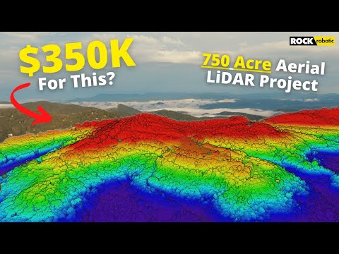
LiDAR for High-Value, High-Speed Projects: The "$350K LiDAR Project" video starkly illustrates the ROI of LiDAR technology for large-scale surveys where time is of the essence. Completing a 750-acre survey in under 12 hours, with deliverables in weeks instead of months, is a game-changer for clients needing rapid turnaround. This showcases LiDAR’s strength in demanding projects where efficiency and speed justify the investment in specialized equipment like the Rock R2A LiDAR system. Imagine the reduced labor costs and project timelines.
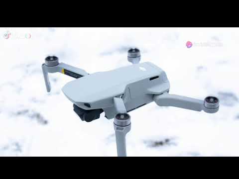
GNSS Precision: The Unsung Hero of Drone Surveying: The video highlighting the "#1 MUST HAVE Drone Surveying Tool" emphasizes the critical role of precise GNSS receivers like the Emlid Reach RS2+. Whether used as a rover, RTK base station, or for PPK workflows, centimeter-level accuracy is paramount for reliable drone mapping. This isn’t just about pretty pictures; it’s about generating survey-grade data for photogrammetry, LiDAR, and orthomosaics. Without accurate positioning, your data is just spatially referenced guesswork.
Accessible Mapping for All: Democratizing Drone Surveying: The "Map for Free with a DJI Mini 3 Pro!" video demonstrates that high-quality mapping is no longer exclusive to high-end equipment. Utilizing consumer-grade drones like the DJI Mini 3 Pro, combined with free processing software, opens the door for smaller projects and wider adoption of drone surveying. This accessibility is crucial for expanding the reach of this technology and empowering more professionals to leverage aerial data. Entry-level drones are now powerful survey tools in the right hands.
Construction and AEC Applications: Drones on the Construction Site: "Drone Surveying for Construction" directly addresses the practical applications of drone photogrammetry in the Architecture, Engineering, and Construction (AEC) industry. From site monitoring to generating 2D maps and 3D models, drones are streamlining workflows, improving data collection efficiency, and enhancing project oversight. The emphasis on ASPRS accuracy standards highlights the professional-grade results achievable with drone-based photogrammetry. Drones are becoming indispensable tools for modern construction management.
Real-World Landfill Survey: Versatility in Challenging Environments: The "I Surveyed a Landfill with a Drone" video provides a compelling case study of drone surveying in a complex and often hazardous environment. This example underscores the versatility of drone technology for topographic surveys across diverse terrains and project types. Landfills, with their uneven surfaces and potential safety concerns, are ideal candidates for drone-based data collection, showcasing the practical advantages in challenging scenarios. Drones can access and map areas that are difficult or dangerous for traditional survey crews.
Optimizing Data Capture: Camera Settings for Survey-Grade Results: The video on "DJI Mavic 3E Camera Settings" dives into the technical details crucial for achieving accurate topographic surveys. Proper camera settings, flight planning, and data acquisition techniques are essential for maximizing data quality, especially when calculating earthwork volumes and stockpile measurements. This highlights the importance of pilot knowledge and operational expertise in ensuring survey-grade deliverables. It’s not just about flying; it’s about flying smart for precise data.
The Trajectory of Drone Surveying: Efficiency, Integration, and Broader Adoption
Analyzing these videos, a clear trend emerges: drone surveying is rapidly evolving from a niche technology to a mainstream tool in topographic mapping. We’re seeing advancements on multiple fronts – from high-precision LiDAR systems tackling large-scale projects to accessible photogrammetry workflows empowering smaller operations. The integration of precise GNSS positioning is becoming standard practice, ensuring the accuracy and reliability of drone-derived data. Looking ahead, we can anticipate even wider adoption across industries as drone technology becomes more user-friendly, data processing becomes more automated, and regulatory frameworks become more streamlined. The ability to rapidly collect and process high-resolution geospatial data from above is not just changing the game; it’s redefining the playing field for topographic surveying professionals.
Take to the Skies: Explore the Future of Surveying
Ready to witness these game-changing technologies in action? Scroll down to explore the video highlights and see firsthand how LiDAR and photogrammetry are revolutionizing topographic surveying. The future of mapping is aerial, and it’s more accessible and powerful than ever before.
Continue below to watch the videos
What Does A $350K LiDAR Project REALLY Look Like?Dylan Gorman245,365 views | 5,869 | September 10 2022 17:00:03 (443 comments)[ Read more … ]
What do you get when you pair a turnkey LiDAR solution and a client that is looking to have an aerial survey completed in 2-3 weeks rather than 2-3 months? This $350,000 LiDAR project I just completed is exactly what ended up happening with my client and me. Check this video out to learn how I was able to capture 750 acres of land in less than 12 hours and provide deliverables to my client in 2-3 weeks’ time from initial data capture!
Thank you Rock Robotic for sponsoring this video! Harrison and his team over at Rock Robotic are a great group of people with a fantastic product and a killer support system to get you up and running with aerial LiDAR quickly.
Learn more about Rock Robotic here: https://www.rockrobotic.com/
►Resources/ Equipment used Rock R2A LiDAR: https://www.rockrobotic.com/drone-lidar-hardware-r2a Emlid RS2 GNSS: https://emlid.com/reachrs2plus/ DJI M300 RTK: https://www.dji.com/matrice-300 DJI D-RTK 2 GNSS: https://www.dji.com/d-rtk-2 UGcS Flight Planning Software: https://www.ugcs.com/ — ► Looking to Fast Track your way to a career in the commercial drone industry? Join many others who have taken this private 4-week mentorship program and see how you can get flying: https://www.pilotbyte.com/course/4-week-private-mentorship-program
►Drones used in the drone industry: 1) “Beginner” – DJI Mini 2: https://amzn.to/3MwY7GO 2) “Beginner” – DJI Air 2s: https://amzn.to/3s2TVGO 3) “Advanced” – DJI Mavic 2 Pro: https://amzn.to/3B2cGhv 4) “Advanced” – DJI Phantom 4 Pro: https://amzn.to/3B7eAx7 5) “Intermediate” – DJI Inspire 2: https://amzn.to/38EerXp 6) “Intermediate” – DJI Mavic 3: https://amzn.to/3LAK3vO
► Subscribe to my channel here: https://www.youtube.com/c/dylangorman — My Camera Equipment! Canon R5: https://amzn.to/36YsAP1 Canon 24-70 2.8L: https://amzn.to/2S2KVCK Rode Microphone: https://amzn.to/3pfokiM Drone: https://amzn.to/3x9GHLW __ Follow me online!
LinkedIn: https://www.linkedin.com/in/dylan-g-099961101/ Instagram: https://www.instagram.com/dylang_1 — Chapters 00:00 Intro 00:48 Why am I capturing LiDAR for this project? 02:35 Equipment/ software overview 03:44 Setting ground controls 04:42 Rock Robotic 06:12 Flight planning w/ google 08:33 Mission automation with UGcS 09:44 In-field data capture 11:44 Data processing 14:18 Analyzing the data 15:57 Processed data review 16:46 Conclusion
0:09 1. The receiver can be configured as a rover setup. 0:19 2. It’s compatible as an RTK base station. 0:31 3. Easily connect two RS2+ units for on-site corrections data 0:41 4. Tough and lightweight for challenging environments 0:48 5. Collection of all types of drone data, photogrammetry, LiDAR, orthomosaics, and more.
In addition, using a receiver like this with centimeter precision in conjunction with Ground Control Points (GCPs) can significantly improve the accuracy and reliability of drone-based Photogrammetry, LiDAR, and survey-grade collection. The Multi-band RTK GNSS receiver is a must-have tool for professionals in surveying, mapping, and construction. Its exceptional accuracy and versatility make it an invaluable asset for a wide range of drone mapping applications, ultimately enhancing productivity and the quality of results.
►About The Drone Life The Drone Life is an industry-leading UAS service provider that provides turnkey aerial data solutions nationwide. We proudly specialize in the industrial, environmental, renewable, and construction industries. Our team consists of highly experienced, dependable, and licensed drone professionals that are committed to safety, quality, and customer success.
Map for Free with a DJI Mini 3 Pro!Pilot Institute88,284 views | 2,338 | May 31 2024 17:00:11 (207 comments)[ Read more … ]
Jared shows how you can make a quality map with a drone. All without spending a single dollar!
New LiDAR course out now: https://pilotinstitute.com/course/drone-lidar/
00:00 Introduction 00:27 Getting Started With Mapping 03:22 Planning the Mission 06:23 Ready to Fly 09:20 Processing 11:48 Viewing the Map
Join our community site: community.pilotinstitute.com
Check out our gear list: https://www.amazon.com/shop/pilotinstitute
Our Other Channel – Pilot Institute Airplane: our airplane channel: https://www.youtube.com/channel/UCIgBjGoM-yn_3bH8Qr9xkXA
Our courses – Part 107 Made Easy: the most comprehensive ground school online. https://bit.ly/2AkRWq0 – Drone Business Made Easy: start your drone business with a solid foundation. https://bit.ly/3dVT55T – Drone Flying 101: the perfect course for beginners. https://bit.ly/2XUy3Pc – Drone Maneuvers Mastery: become a better pilot with these 50 maneuvers designed to improve your flying skills. https://bit.ly/3hkWkG3 – Cinematic FPV Drone From Scratch: build your own cinematic machine with this course. https://bit.ly/37oOfeG
Get Pilot Institute Gear: https://merch.pilotinstitute.com
Drone Surveying for Construction – Photogrammetry & MappingThe Drone Life7,412 views | 196 | September 12 2023 20:17:29 (0 comments)[ Read more … ]
Claim Your FREE GUIDEBOOK to Using Drones in Construction 👇 https://bit.ly/42MY2b9
Discover the future of the AEC industry with drone mapping and photogrammetry solutions in our latest video! Learn how automated drone flights are revolutionizing data collection, meeting ASPRS accuracy standards, and streamlining construction monitoring. From precise 2D maps to 3D models, our versatile drone-based photogrammetry covers a wide range of applications, reducing man-hours and enabling proactive issue detection.
With seamless software integration and compatibility with existing tools, you can enhance data analysis and visualization. Embrace unprecedented efficiency and accuracy while harnessing actionable insights for informed decision-making. If you’re ready to implement drone solutions, The Drone Life’s experienced, licensed, and OSHA-certified pilots are here to assist you. Visit thedronelifenj.com for more information and consultation with our experts!
►Resources The Ultimate Beginner’s Guide to Drone Photogrammetry https://thedronelifenj.com/drone-photogrammetry-beginner-guide/
►Our Must-Have Drone Equipment Checklist ✅ Budget Friendly Ground Control Points (GCPs) – http://bit.ly/3nAT2pH ✅ Drone Mapping RTK Base & Rover GNSS Reciever – https://bit.ly/3Jo526a ✅ Most Reliable SD Card for Drone Mapping – http://bit.ly/3lZOhWn ✅ Heavy Duty Landing Pad – http://bit.ly/3zt1hXA ✅ Collapsable Orange Safety Cones – http://bit.ly/40Tr2fp ✅ OSHA Certified Safety Vest -http://bit.ly/3KsycSt ✅ Wind Speed Anemometer Gauge – http://bit.ly/3ZCaYO5 ✅ Best Flight Planning Tablet – http://bit.ly/40Dci4q ✅ Handheld VHF Airband Transceiver – http://bit.ly/40AyLPP
►About The Drone Life The Drone Life is an industry-leading UAS service provider that provides turnkey aerial data solutions nationwide. We proudly specialize in the industrial, environmental, renewable, and construction industries. Our team consists of highly experienced, dependable, and licensed drone professionals that are committed to safety, quality, and customer success.
I Surveyed a Landfill with a DroneRami Tamimi, P.S.24,272 views | 743 | July 1 2022 19:22:42 (57 comments)[ Read more … ]
Join The Survey School – https://thesurveyschool.com/
Join me on Social Media: 🖥️ Website: https://www.tamimi.biz 👤 Facebook: https://www.facebook.com/tamimibiz 👕 Survey Shirts – https://www.SurveyShirts.com 👥 Private Facebook Group: https://www.facebook.com/groups/iamasurveyor 📸 Instagram: https://www.instagram.com/ramitamimi 👔 LinkedIn: https://www.linkedin.com/in/ramitamimi ✉️ Email: rami@tamimi.biz
About Professor Rami Tamimi: Rami Tamimi is an American doctorate student at The Ohio State University working towards his Doctor of Philosophy in Geodetic Engineering. With over 8 years of experience in the Land Development Industry, his experience revolves around traditional field surveying, civil design work using AutoCAD Civil 3D, and geospatial technology including LiDAR, SONOR, and Photogrammetric data acquisition and processing with the use of Unmanned Aircraft Systems or Drones. He is also a University Professor and creates instructional video content on YouTube.
#dronemapping #Pix4d #phantom4rtk
DJI Mavic 3E Camera Settings for Topographic Survey MappingQuantum Land Design17,158 views | 108 | April 21 2023 14:56:25 (13 comments)[ Read more … ]
Easy to follow camera settings to fly topographic survey missions with your Quantum Flight Pack. These flight settings are optimized for the Mavic 3E drone to collect data on an earthmoving or quarry site.
Fly your sites to determine earthwork volume calculations, stockpile calcs even calculate production in conjunction with your GPS machine control system.
We are showing DJI Pilot 2 on a Mavic 3 Enterprise (M3E) here. In general, the same settings will apply to any DJI drone with mapping capabilities.
Free machine control and drone data resources – www.quantumlanddesign.com/education
Machine Control Models – www.quantumlanddesign.com/machine-control-data-prep
Email sales@avqld.com with questions.
About the Author
Patryk Alexander is an associate copy editor at 4kVideoDrones.com, where he sharpens articles and helps keep the website's content clean and error-free. With a background in creative writing, Patryk brings a unique perspective to his editing that helps make 4kVideoDrones.com's content engaging and informative. When he's not editing or writing, Patryk enjoys spending time with his family and exploring the great outdoors.