Can drones really boost your bottom line? These YouTube videos tackle the practicalities of using drones for business, specifically surveying, and delve into the critical aspects of operation, airspace regulations, and data accuracy. From pre-flight planning using apps like OpenSky and UAV Forecast to understanding the nuances of photogrammetry and orthomosaic generation, these resources offer a valuable launchpad for businesses considering drone integration. The core message resonates with the potential for increased efficiency, improved data acquisition, and ultimately, soaring profits – but not without careful planning and execution.
Actionable Insights for Drone Entrepreneurs
Survey-Grade Precision: Drones equipped with LiDAR and utilizing techniques like photogrammetry offer highly accurate surveying data, enabling the creation of detailed orthomosaics – essentially, geometrically corrected aerial images. This translates to faster, more efficient data collection compared to traditional methods.
RTK vs. PPK – Accuracy Matters: Understanding the difference between Real-Time Kinematic (RTK) and Post-Processed Kinematic (PPK) correction is crucial for accurate geospatial data. RTK provides real-time corrections via a base station, while PPK relies on post-processing data for potentially higher accuracy. Choosing the right method impacts the precision of your surveying results.
Mastering Drone Operations:Safe and legal drone operation is paramount. Videos highlight the importance of airspace authorization using apps like OpenSky, meticulous weather tracking with UAV Forecast, and detailed mission planning. These pre-flight steps ensure compliance with FAA regulations and contribute to successful missions.
Integration Challenges and Solutions: Even seemingly unrelated videos, like integrating Starlink into a home network, offer valuable insights into network connectivity challenges and solutions relevant to remote drone operations. Reliable communication between the drone and ground station is critical for real-time data transfer and control.
Beyond the Horizon: The Future of Drone-Powered Business
While the analyzed videos primarily focus on surveying, the underlying principles of data acquisition, automation, and operational efficiency are applicable across numerous industries. Imagine drones streamlining inspections of infrastructure, monitoring agricultural fields, or even delivering goods. As technology evolves – including advancements in autonomous flight and data analytics – the potential applications for drones in business are limitless. We’re on the cusp of a drone revolution, and businesses that adapt and integrate this technology strategically are poised to reap substantial rewards.
Ready for Takeoff? Explore the Videos Below
This overview just scratches the surface. Dive deeper into the world of drones for business by exploring the curated video selection below. Each video offers unique insights and practical advice to help you navigate the exciting landscape of commercial drone operations. Scroll down to watch the highlights and elevate your business to new heights!
Continue below to watch the videos
Integrating Drones Into Your Surveying Business – Needs & Necessities, Photogrammetry & OrthomosaicsSmartDrone | “The U.S.A. Drone Company”®179 views | 1 | March 3 2023 18:53:20 (0 comments)[ Read more … ]
Hear from Greenville Field Application Specialist (FAS) Bobby Mullinax as he discusses the needs and necessities for utilizing drones for mapping and surveying. Understand what photogrammetry is and how it works with orthomosaic generation.
Filmed live at the 2023 SCSPLS Annual Convention in Columbia, SC, on February 23, 2023.
Interested in becoming a commercial drone pilot? Download our Pt. 107 Remote Pilot’s Certificate guide: https://f.hubspotusercontent30.net/hubfs/4329732/FAA%20Pt%20107%20Study%20Guide.pdf
Read more about Drones & Surveying:
The Top 3 Myths About Drones and Land Surveying: https://blog.smartdrone.us/insights/the-top-3-myths-about-drones-and-land-surveying
What Are the Advantages of Drone Surveys vs. Traditional Methods?: https://blog.smartdrone.us/insights/what-are-the-advantages-of-drone-surveys-vs-traditional-methods
5 Benefits of Drone Surveys: https://blog.smartdrone.us/insights/5-benefits-of-drone-surveys
Learn more about Discovery 2: https://www.smartdrone.us/product/discovery
Learn more about our Professional Services: https://www.smartdrone.us/services/professional-services
Continue learning at our Knowledge Base: https://support.smartdrone.us/knowledge
SmartDrone is a leader in drone surveying innovation and technology for accurate land surveying, utilizing U.S.-manufactured drone hardware to collect feasible aerial LiDAR data, combined with streamlined processing software for that data.
Integrating Drones Into Your Surveying Business – Needs & Necessities, RTK vs. PPK CorrectionsSmartDrone | “The U.S.A. Drone Company”®214 views | 3 | March 3 2023 18:49:20 (0 comments)[ Read more … ]
Hear from Greenville Field Application Specialist (FAS) Bobby Mullinax as he discusses the needs and necessities for utilizing drones for mapping and surveying. Understand the difference between RTK and PPK corrections.
Filmed live at the 2023 SCSPLS Annual Convention in Columbia, SC, on February 23, 2023.
Interested in becoming a commercial drone pilot? Download our Pt. 107 Remote Pilot’s Certificate guide: https://f.hubspotusercontent30.net/hubfs/4329732/FAA%20Pt%20107%20Study%20Guide.pdf
Read more about Drones & Surveying:
The Top 3 Myths About Drones and Land Surveying: https://blog.smartdrone.us/insights/the-top-3-myths-about-drones-and-land-surveying
What Are the Advantages of Drone Surveys vs. Traditional Methods?: https://blog.smartdrone.us/insights/what-are-the-advantages-of-drone-surveys-vs-traditional-methods
5 Benefits of Drone Surveys: https://blog.smartdrone.us/insights/5-benefits-of-drone-surveys
Learn more about Discovery 2: https://www.smartdrone.us/product/discovery
Learn more about our Professional Services: https://www.smartdrone.us/services/professional-services
Continue learning at our Knowledge Base: https://support.smartdrone.us/knowledge
SmartDrone is a leader in drone surveying innovation and technology for accurate land surveying, utilizing U.S.-manufactured drone hardware to collect feasible aerial LiDAR data, combined with streamlined processing software for that data.
Integrating Drones Into Your Surveying Business – Drone OperationsSmartDrone | “The U.S.A. Drone Company”®74 views | 0 | March 3 2023 18:37:18 (0 comments)[ Read more … ]
Hear from Greenville Field Application Specialist (FAS) Bobby Mullinax as he discusses the proper operations for utilizing drones for mapping and surveying. What he covers: airspace approval, tracking weather, mission planning, and more.
Filmed live at the 2023 SCSPLS Annual Convention in Columbia, SC, on February 23, 2023.
Interested in becoming a commercial drone pilot? Download our Pt. 107 Remote Pilot’s Certificate guide: https://f.hubspotusercontent30.net/hubfs/4329732/FAA%20Pt%20107%20Study%20Guide.pdf
Read more about Drones & Surveying:
The Top 3 Myths About Drones and Land Surveying: https://blog.smartdrone.us/insights/the-top-3-myths-about-drones-and-land-surveying
What Are the Advantages of Drone Surveys vs. Traditional Methods?: https://blog.smartdrone.us/insights/what-are-the-advantages-of-drone-surveys-vs-traditional-methods
5 Benefits of Drone Surveys: https://blog.smartdrone.us/insights/5-benefits-of-drone-surveys
Learn more about Discovery 2: https://www.smartdrone.us/product/discovery
Learn more about our Professional Services: https://www.smartdrone.us/services/professional-services
Continue learning at our Knowledge Base: https://support.smartdrone.us/knowledge
SmartDrone is a leader in drone surveying innovation and technology for accurate land surveying, utilizing U.S.-manufactured drone hardware to collect feasible aerial LiDAR data, combined with streamlined processing software for that data.
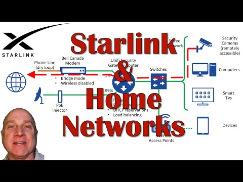
Tips for Integrating Starlink into your Home NetworkDon Joyce173,538 views | 0 | March 26 2021 01:53:06 (384 comments)[ Read more … ]
Starlink’s default wireless network works for many folks, but if you already have some sort of home network in place, you should watch this video for tips on how to incorporate Starlink into that network and how to overcome some current Starlink limitations.
A DonDronesOn production.
Ubiquiti Unifi Security Enterprise Gateway Router with Gigabit Ethernet: https://www.amazon.ca/dp/B00LV8YZLK/?ref=idea_lv_dp_ov_d
UBIQUITI UAP-AC-LITE Unifi AP AC LITE Wireless Access Point: https://www.amazon.ca/dp/B01DRM6MLI/?ref=idea_lv_dp_ov_d
SUGGESTIONS: Join the Drone Pilot Association of Canada: https://www.DronePilotAssociationOfCanada.com Purchase the Drone Pilot Canada app: Apple iOS platform: https://itunes.apple.com/ca/app/drone-pilot-canada/id1455291540 Android platform: https://play.google.com/store/apps/details?id=com.myappatory.dronecanada Purchase my Canadian drone exam Study Guides: https://www.pocketwatchpurveyor.com/collections/drone-study-guides Join my Facebook group: https://www.facebook.com/groups/592682344571622/ Buy me a coffee! https://www.buymeacoffee.com/DonDronesOn
DRONES AND ACCESSORIES I RECOMMEND: DJI Mini 3 Pro drone: https://amzn.to/3PidRhP DJI Mini 3 Pro Fly More Kit: https://amzn.to/3p9u9Pg DJI Mini 3 Pro Freewell ND filters: https://amzn.to/3QDxJgz DJI Mini 3 Pro Controller Lanyard: https://amzn.to/3bPxJen DJI Mini 3 Pro propeller holder strap: https://amzn.to/3p6Ws13 SanDisk Extreme PRO 128Gb MicroSD card: https://amzn.to/3AfuQgC Kovol 65W 4-port USB-C PD Charger: https://amzn.to/3Pa8X6s DJI Mini 2 drone Fly More Combo: https://amzn.to/3JLhqMd DJI Mavic 2 Pro drone Fly More Combo: https://amzn.to/3zUxbfA Tripltek 8 Pro 8” Tablet: https://www.tripltek.com/tripltek8 Tripltek tablet holder for Mavic 2 controller: https://amzn.to/3QE2qCm
VIDEO EDITING AND CREATION ELEMENTS I RECOMMEND: Video editor: Cyberlink PowerDirector referral link: https://membership.cyberlink.com/event/trace.jsp?linkId=329057&e=27628485&affid=2581_1464_926_auto-content-pack-notification_20200731_en_CA&traceLink=https%3A%2F%2Fmembership.cyberlink.com%2Fl.jsp%3Flang%3DENU%26event%3D4435%26e%3D646F6E6A6F79636533343340676D61696C2E636F6D Music: Epidemic Sound. Referral link with one month free: https://www.epidemicsound.com/referral/4jk9fj/
#starlink #dondroneson
Safely Integrating Drones into U.S. Airspace: NASA, UNR and Private Sector TechnologiesTahoe Silicon Mountain62 views | 0 | July 12 2016 03:04:15 (0 comments)[ Read more … ]
http://www.tahoesiliconmountain.com/
Tahoe Silicon Mountain, a network of technology professionals who live and work in the Tahoe-Truckee area, is pleased to welcome Dr. Richard Kelley to present: “Safely Integrating Drones into U.S. Airspace: NASA, UNR and Private Sector Technologies”
Drone technology has the potential to be a multibillion industry in the next ten years. Air traffic control systems for both drones and humans will be key to realizing this potential.
Dr. Richard Kelley, Engineer at the Nevada Advanced Autonomous Systems Innovation Center, will touch on the basics of commercial drone technology and will explain how the University of Nevada, NASA and several Nevada companies are building an air traffic control system for small drones using the Nevada Unmanned Aircraft and Nextgen Collaborative Environment Laboratory (NUANCE) at the Reno-Stead Airport, a facility dedicated to aerospace and autonomous systems research.
You can learn more about Nevada Advanced Autonomous Systems Innovation Center here: http://www.unr.edu/naasic
The meeting will be on Monday, July 11th, 6-8 pm at Pizza on the Hill, in Tahoe Donner at 11509 Northwoods Blvd., Truckee. A $5 fee includes pizza and salad. Before and after the presentation, there will be time for networking with other technology professionals who live and work in the Tahoe-Truckee region.
The event will also be livestreamed and available online as it happens on YouTube: bit.ly/YouTubeTSM
This month’s event is sponsored by New Leaders, Clear Capital, Holland & Hart LLP and Code Tahoe.
You can find us on LinkedIn and Facebook and at TahoeSiliconMountain.com or sign up for email meeting announcements here: bit.ly/14XGofL.
Safe Integration of Drones Into the NAS is EssentialNBAA – National Business Aviation Association6 views | 0 | November 4 2024 03:49:50 (0 comments)[ Read more … ]
presents opportunities for business aviation and NBAA is working to ensure that such systems are integrated safety into the airspace.
The post Safe Integration of Drones Into the NAS is Essential (https://nbaa.org/news/flight-plan/safe-integration-drones-nas-essential/) appeared first on NBAA – National Business Aviation Association (https://nbaa.org) .
About the Author
Patryk Alexander is an associate copy editor at 4kVideoDrones.com, where he sharpens articles and helps keep the website's content clean and error-free. With a background in creative writing, Patryk brings a unique perspective to his editing that helps make 4kVideoDrones.com's content engaging and informative. When he's not editing or writing, Patryk enjoys spending time with his family and exploring the great outdoors.