From individual ground control points (GCPs) to LiDAR-equipped octocopters, the world of drone terrain mapping is rapidly evolving. These videos offer a comprehensive overview of this exciting field, covering everything from basic terminology to advanced techniques for data acquisition and processing. Whether you’re a construction professional, a surveyor, or simply a drone enthusiast, understanding the power of terrain data is crucial in today’s world. This revolution in terrain intelligence empowers us to make informed decisions, optimize projects, and unlock new possibilities across various industries.
Key Insights from the Field
Simplified Data Acquisition: Streamline your workflow with techniques like using a single GCP for accurate drone data, even with readily available drones like the DJI Mavic 3 Enterprise. This democratizes access to precise mapping for everyone.
Construction Revolutionized:Drone mapping transforms construction sites, enabling efficient progress monitoring, improved communication among stakeholders, and precise measurements for earthworks and volumetrics calculations. This leads to cost savings and improved project timelines.
Decoding the Language of Mapping: Master the essential terminology of drone mapping, from GSD (Ground Sampling Distance) and overlap to complex concepts like point clouds and textured meshes. A clear understanding of these terms is fundamental to successful mapping missions.
LiDAR for Unprecedented Detail: Explore the power of LiDAR (Light Detection and Ranging) technology for capturing centimeter-level accuracy in terrain data. LiDAR’s ability to penetrate vegetation opens up new possibilities for geological surveys and environmental monitoring.
Educational Resources Abound: Beginner-friendly resources like "Mapping 101" provide foundational knowledge about drone mapping, photogrammetry, and 3D modeling, making this technology accessible to newcomers.
The Future is Now: Trends in Terrain Intelligence
The convergence of increasingly affordable drone technology, powerful processing software, and accessible educational resources signals a bright future for drone terrain mapping. As sensor technology continues to advance and AI-powered analytics become more sophisticated, we can expect even greater automation and insights from aerial data. Imagine a future where real-time terrain data informs autonomous decision-making in fields like disaster response, infrastructure inspection, and precision agriculture.
Ready to Take Off? Explore the World of Drone Mapping
Dive deeper into the fascinating world of drone terrain mapping by exploring the video highlights below. From practical tips and tricks to in-depth explanations of complex concepts, these videos provide a wealth of knowledge for anyone looking to harness the power of drones for terrain intelligence. Scroll down and discover the future of mapping!
View the videos just below
Level Up Your Drone Data with Only ONE GCPDo You Know Drones?14,465 views | 414 | March 21 2023 12:10:38 (39 comments)[ Read more … ]
In this workflow video, we walk through one way to level up your drone data with only ONE GCP. We will be using the DJI Mavic 3 Enterprise with the RTK Module, a single Propeller Aeropoint 2 ground control point, DroneDeploy and TopoDrone in this end-to-end workflow.
Workflow Timestamps: 0:00 Introduction 0:55 PPK vs RTK 1:49 Mission Planning 13:15 Field Work 20:18 Data Processing 35:30 Results
There are several ways to get these results, so please feel free to adjust this workflow to your specifications.
Thanks for watching and let me know in the comments what you want me to cover in future episodes.
SPECIAL THANKS to DroneDeploy, Propeller Aero, TopoDrone, and Blue Nose Aerial Imaging.
Advertisement
Drone Mapping for Construction: Complete GuideThe Drone Life326,587 views | 9,166 | November 17 2021 22:43:05 (170 comments)[ Read more … ]
Claim Your FREE GUIDEBOOK to Using Drones in Construction 👇 https://bit.ly/42MY2b9
In this video, you will learn what are orthomosaic drone maps, the benefits of drone mapping in construction, and how to map a construction site using a drone.
So if you are a construction company looking to get started in drone mapping or if you’re a pilot looking to expand your service offerings, this video is for you.
We’ve been producing 2D orthomosaic maps at this 500,000 Sq Ft warehouse job site. These maps are greatly beneficial for improving communication, planning construction phases, keeping records, monitoring progress, and sharing with project stakeholders.
Using a Mavic 2 Pro drone and mapping software Dronedeploy, we’re going to share our mapping workflows, best practices, and tips!
►Resources ➡️ Start Your FREE 14-Day DroneDeploy Trial Now – http://bit.ly/3EPADdN
►Our Must-Have Drone Equipment Checklist ✅ Budget Friendly Ground Control Points (GCPs) – http://bit.ly/3nAT2pH ✅ Most Reliable SD Card for Drone Mapping – http://bit.ly/3lZOhWn ✅ Heavy Duty Landing Pad – http://bit.ly/3zt1hXA ✅ Collapsable Orange Safety Cones – http://bit.ly/40Tr2fp ✅ OSHA Certified Safety Vest -http://bit.ly/3KsycSt ✅ Wind Speed Anemometer Gauge – http://bit.ly/3ZCaYO5 ✅ Best Flight Planning Tablet – http://bit.ly/40Dci4q ✅ Handheld VHF Airband Transceiver – http://bit.ly/40AyLPP
►About The Drone Life The Drone Life is an industry-leading UAS service provider that provides turnkey aerial data solutions nationwide. We proudly specialize in the industrial, environmental, renewable, and construction industries. Our team consists of highly experienced, dependable, and licensed drone professionals that are committed to safety, quality, and customer success.
►Chapters 0:00 Intro 0:34 What are orthomosaic drone maps? 1:21 Benefits of drone mapping 3:58 Flight planning 14:28 Flying the site 18:49 Conclusion
#dronemapping #dronesinconstruction #construction
Advertisement
50 Drone Mapping Words – Explained! | Hammer MissionsHammer Missions450 views | 27 | July 23 2024 10:43:02 (3 comments)[ Read more … ]
In this video, Varun from Hammer Missions will walk you through 50 of the most commonly used drone mapping words! ————————————————————————–
#dronemapping #droneinspections ————————————————————————– About Us:
Hammer Missions is a software platform for drone professionals and Enterprise UAS programmes to collect & process high-quality drone data for aerial surveys & inspections.
To try Hammer Missions on our 14 day trial, visit: ➤➤➤ https://www.hammermissions.com ————————————————————————– Related Videos:
1. GSD: https://youtu.be/xfcf4B_HdBw 2. GCPs: https://youtu.be/ogUOBJigu3Y 3. Aligning Drone Images: https://youtu.be/2_ulJZTYJwA 4. Relative vs Absolute Accuracy: https://youtu.be/eNwrXBuMqZg 5. Drone Data Formats: https://youtu.be/ZtyJE8i8B58 6. Scan to BIM: https://youtu.be/pzgUdDd5e9Y ————————————————————————–
shot at when hiking with fpv Drone !! 😱GDZ80,170 views | 473 | February 12 2024 20:56:38 (289 comments)[ Read more … ]
Getting shot at when hiking with fpv Drone !! 😱
If you follow me on Instagram you will probably of seen the experience I had in the Swiss alps hiking with my fpv drone, I recommend you guys to watch it all to understand what is going on here. but long story short I was hiking in the siwss alps and when i was flying my fpv drone a guy was pointing his rifle at the drone trying to get a shot of the drone but this isn’t easy to do when you have tourists bellow and firing a bullet into a tourist location isn’t a good idea. after we packed up from our fpv flight we was heading down and a bullet ricochet past us and you hear the gun shot shortly after Im not sure if this was shot to scare us off or what but does seem a bit reckless shooting a rifle into a hiking path !
let us know what you think about this situation and how you would react
If you are interested in the gear i used for fpv they are as follows
custom 7 inch fpv frame 1800kv motors from mepsking speedybee f7 stack walksnail fpv gear Jumper t20 with crossfire
also if you enjoyed the video dont forget to smash that like a sub button helps me out alot
until next time peace out ✌️✌️
#fpv #drone #hiking #flying #story #gunshot 00:00 Intro 00:33 hike plan 01:00 cable cart to pfingstegg 01:34 hike to the top ! 05:40 reaching the Berghaus B regg 06:04 first fpv flight story starts 07:50 slow mo rifle shooter 09:12 hiking back down 10:34 getting shot at hiking down 12:31 enjoying hike down to pfingstegg 16:41 the end !
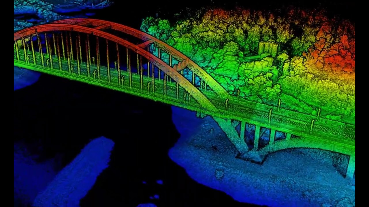
Centimeter-level LiDAR Drone Aerial Geological Mapping Solution | Hawk-100C+ LiDAR CameraFoxtech Robot22,604 views | 82 | September 7 2022 08:24:33 (2 comments)[ Read more … ]
Get more details: http://www.foxtechrobot.com/hawk-100c-lidar-camera-with-naga-pro-octocopter-drone-for-aerial-geological-mapping.html
Please contact us if you have any requirements: https://direct.lc.chat/13339812/2
LiDAR is an effective tool for mapping terrain features, vegetation, buildings, power lines, and other structures. Hawk -100C+ LiDAR can be installed on our NAGA Pro octocopter to quickly and efficiently obtain the three-dimensional position and attribute information of ground objects in a large area, then generate digital images like DOM (with integrated camera), DEM, DLG, and DSM through data processing software, greatly improving people’s work efficiency.
Features: – 110m measuring range – Triple echo, 720,000 points/sec, strong penetrability, 70 FOV – Built-in 26MP camera, 83 FOV – The endurance of NAGA Pro is 60 minutes loading with the Hawk-100C+ LiDAR
Advertisement
Mapping 101 – Introduction to Drone MappingDJI Enterprise23,962 views | 524 | February 7 2022 09:05:48 (20 comments)[ Read more … ]
Welcome to the first episode of Mapping 101 with DJI Enterprise 🎙
Join Michael as he explains how Drone Mapping has changed the Surveying and Mapping Industry.
By the end of the video, you will not only understand the advantages of using drones to plan and execute a mapping mission but also, have a basic understanding of concepts such as Drone Mapping, Photogrammetry, 3D Modeling, and Digital Twins.
Learn more: DJI Zenmuse P1: https://www.dji.com/zenmuse-p1?site=brandsite&from=nav DJI Enterprise Blog: https://enterprise-insights.dji.com/blog Like us on Facebook: https://www.facebook.com/DJIEnterpriseOfficial Follow us on Twitter: http://www.twitter.com/DJIEnterprise Follow us on LinkedIn: https://www.linkedin.com/company/dji/
Patryk Alexander is an associate copy editor at 4kVideoDrones.com, where he sharpens articles and helps keep the website's content clean and error-free. With a background in creative writing, Patryk brings a unique perspective to his editing that helps make 4kVideoDrones.com's content engaging and informative. When he's not editing or writing, Patryk enjoys spending time with his family and exploring the great outdoors.