Unlock the future of mapping with drones! Explore cutting-edge tech & precision surveying. Click to take flight!
Taking Off: Exploring the Future of Aerial Surveying
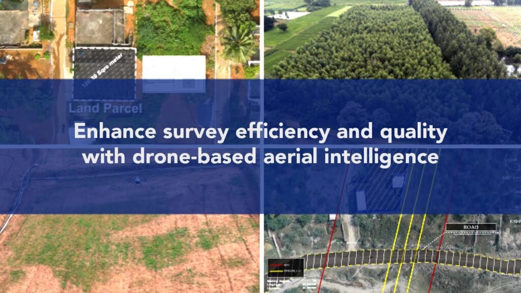
The world of mapping and surveying has been revolutionized by drones. These versatile aircraft offer unprecedented speed, efficiency, and detail, transforming how we collect and analyze geospatial data. From compact photogrammetry platforms to sophisticated LiDAR systems, today’s drones cater to a wide array of surveying needs. This curated collection of YouTube video insights provides a valuable overview of cutting-edge drone technology, software integration, and real-world applications for mapping and surveying professionals and enthusiasts. We’ll explore everything from achieving centimeter-level accuracy with LiDAR to maximizing the potential of compact, budget-friendly drones for photogrammetry. Buckle up, pre-flight checks complete – let’s explore the exciting landscape of drone-based mapping and surveying.
Key Insights from the Drone Hangar
LiDAR Dominance: Videos showcasing the ROCK R3 Pro and DJI Zenmuse L2 highlight the increasing prominence of LiDAR technology for high-precision surveying applications, especially in challenging environments like dense vegetation. These systems provide incredibly detailed point cloud data, enabling accurate 3D models of terrain and infrastructure.
Compact Powerhouses: The DJI Mini 3’s emergence as a viable photogrammetry platform, thanks to third-party software integration, demonstrates how even smaller, more affordable drones can deliver valuable mapping data. This opens doors for wider adoption of drone surveying across various industries.
Software Integration is Key: Videos demonstrating automated flight planning and data processing with software like DroneDeploy and DJI Terra emphasize the critical role of software in maximizing the efficiency and accuracy of drone surveying workflows. Streamlined workflows from flight planning to data analysis are becoming the standard.
RTK for Precision: The review of the DJI Mavic 3 Enterprise RTK, paired with the Reach RS2, underscores the importance of Real-Time Kinematic positioning for achieving centimeter-level accuracy in mapping projects. This technology allows for precise georeferencing of data, crucial for accurate surveys.
Vegetation Penetration: The focus on LiDAR’s ability to penetrate vegetation reveals its game-changing potential for forestry management, power line inspections, and other applications where traditional surveying methods are limited. Seeing beneath the canopy provides invaluable insights previously impossible to obtain efficiently.
Charting the Course: Future Trends in Drone Surveying
The rapid advancements showcased in these videos point towards a future where drone surveying becomes even more accessible, powerful, and integrated. We can anticipate even more compact and affordable LiDAR systems, making the technology within reach of a broader user base. Further development in AI-powered data analysis will automate complex tasks like feature extraction and object recognition, dramatically reducing processing time and increasing efficiency. Cloud-based platforms will likely play an even more prominent role in data sharing and collaboration, fostering seamless teamwork between surveyors, engineers, and clients.
Ready for Takeoff?
This overview provides a glimpse into the exciting advancements in drone technology and their impact on the field of mapping and surveying. Now, dive deeper by exploring the curated video highlights below and gain firsthand knowledge from industry experts and practical demonstrations. Let’s unlock the full potential of drones and reshape the future of geospatial data acquisition together!
Find the videos below
Best LiDAR Drone in the World (2023)Indiana Drones212,996 views | 1,022 | April 20 2023 13:00:14 (110 comments)[ Read more … ]
Visit https://www.rockrobotic.com/r3pro to learn more!
🌐 🚁 Unveiling the ROCK R3 Pro Drone LiDAR: The Ultimate Tool for Aerial Mapping Professionals!
Check out our exclusive first look and detailed walkthrough of the ROCK R3 Pro here: ➡️ https://www.rockrobotic.com/r3pro
The ROCK R3 PRO Drone LiDAR offers:
✅ Unmatched Precision: Achieve cm-level accuracy with its powerful LiDAR sensor and cutting-edge technology.
✅ Easy Integration: Compatible with a wide range of drone platforms, making it a versatile and adaptable solution.
✅ Quick and Efficient Data Collection: Capture up to 1,280,000 points per second, allowing you to complete projects in record time.
✅ Rugged and Reliable: Designed with a robust build to withstand harsh environments and challenging conditions.
✅ ROCK Cloud: Access the powerful cloud-based platform for data processing, analysis, and sharing of your LiDAR data.
🌟 Get ready to elevate your aerial mapping game with the ROCK R3 Pro Drone LiDAR! Explore the official product page for more information, or contact the ROCK Robotic team for further inquiries: ➡️ https://www.rockrobotic.com/r3pro
Don’t forget to like, share, and subscribe to our channel for more updates on the latest drone and LiDAR technology! Stay ahead of the curve and unlock the future of aerial mapping with us! 🎥 🚀
The DJI Mini 3 Just Got BETTER | DJI Mini 3 PhotogrammetryDylan Gorman196,182 views | 4,030 | April 22 2023 16:30:06 (412 comments)[ Read more … ]
The DJI Mini 3 has finally received its long-awaited SDK support which now allows it to work with 3rd party software. Unleash the potential of this compact powerhouse for industries like aerial photogrammetry, agriculture, and more. Watch as we demonstrate the versatility of the DJI Mini 3, showcasing its first 3rd party app integration, and offering insights into the future of drone technology.
—
► Join us on Pilot Byte! Our platform provides current and aspiring drone operators with information and resources to promote growth and development in the drone industry: https://www.pilotbyte.com
► Subscribe to my channel here: https://www.youtube.com/c/dylangorman
—
My Camera Equipment!
Canon R5: https://amzn.to/36YsAP1
Canon 24-70 2.8L: https://amzn.to/2S2KVCK
Rode Microphone: https://amzn.to/3pfokiM
Drone: https://amzn.to/3x9GHLW
__
Follow me online!
LinkedIn: https://www.linkedin.com/in/dylan-g-099961101/
Instagram: https://www.instagram.com/dylang_1
—
Chapters
00:00 Intro
01:03 Mini 3 SDK Support
01:42 What you need to fly automated missions
02:42 Mission planning with Mini 3
05:11 Air2s Giveaway & Virtual Workshop Info
06:08 Automated data capture with Mini 3
07:57 Processed Mini 3 data review
11:19 Key takeaways
12:08 Outro
DJI Mini 3, Mini 3 Mapping, Mini 3 Photogrammetry, Mini 3 Pro, Mini 3 Pro Mapping, Mini 3 Pro Photogrammetry
How Accurate is Drone LiDAR using DJI Zenmuse L2Rami Tamimi48,549 views | 966 | December 13 2023 17:00:28 (83 comments)[ Read more … ]
🌟 Discover the Power of DJI Zenmuse L2 LiDAR Sensor! 🌐 | In-Depth Mapping with DJI M350 Drone – A Game-Changer in Surveying! 🚁💡
Join The Survey School – https://thesurveyschool.com/
📏 Exploring Advanced Mapping Technology: Join me in this enlightening journey as I test the groundbreaking DJI L2 LiDAR sensor. I’ll guide you through its impressive capabilities for surveying and mapping, showcasing how it revolutionizes data collection.
🌍 Real-World Application – Power Line Survey: Witness the sensor in action as I undertake a meticulous power line survey. Learn about setting up ground control points, planning drone flights, and the precision of data analysis with DJI Terra software.
🔍 In-Depth Review and Insights: Dive deep into the features and benefits of the DJI L2 LiDAR sensor. Perfect for professionals in surveying, drone enthusiasts, and technology lovers looking for the next big thing in mapping technology.
Distant by Ghostrifter Official https://bit.ly/ghostrifter-sc
Creative Commons — Attribution-NoDerivs 3.0 Unported
Free Download / Stream: https://bit.ly/3k6BzQL
Music promoted by Audio Library: https://www.audiolibrary.com.co/ghostrifter-official/distant
Chapters:
0:00 Intro
0:11 DJI Zenmuse L2 LiDAR Sensor
1:00 Project Overview and measuring GCPs
2:45 Setting up DJI M350 with L2 LiDAR Sensor
6:07 Flying the mission
9:15 Visualizing the Point Cloud
12:52 Control and Check Point Accuracies
🚀 Stay Updated:
Subscribe to our channel for more informative videos on Surveying and Geospatial Technology.
👤 Facebook: https://www.facebook.com/tamimibiz
👕 Survey Shirts – https://www.SurveyShirts.com
📸 Instagram: https://www.instagram.com/ramitamimi
👔 LinkedIn: https://www.linkedin.com/in/ramitamimi
✉️ Email: rami@tamimi.biz
#DJIL2 #dronelidar #surveying
Why Use Drone LiDAR?Indiana Drones90,185 views | 410 | October 9 2023 22:56:13 (42 comments)[ Read more … ]
Vegetation Penetration: The #1 Reason for Drone LiDAR! 🌳
ROCK Robotic Does it Best! – https://www.rockrobotic.com
In this video, we demonstrate how the ROCK Ecosystem™ featuring the ROCK R3 Pro (https://www.rockrobotic.com/r3-pro), ROCK Desktop (https://www.rockrobotic.com/desktop), and ROCK Cloud (https://www.rockrobotic.com/cloud) work seamlessly together to enable surveyors to work faster, safer, and more accurately.
➡️ Read the article to learn more: https://www.rockrobotic.com/post/vegetation-penetration-the-1-reason-for-drone-lidar
The ROCK Ecosystem is a game-changing end-to-end professional surveying solution! Here’s what’s inside:
✅ Capture with the R3 Pro
✅ Verify in the field with ROCK Desktop
✅ Process with ROCK Cloud
✅ Learn with ROCK Academy
✅ Support in the field and in the office
✅ ROCK SLAM
ℹ️ Learn more about ROCK Robotic: https://www.rockrobotic.com
🔎 See the data in the Cloud: https://cloud.rockrobotic.com/share/c67c7437-f8ae-4951-8348-ed093870a14c
💬 Talk to sales: https://www.rockrobotic.com/talk-to-sales
🔔 Be sure to like, share & subscribe for more videos like this one!
DJI Mavic 3 Enterprise RTK Review: Mapping Mission with Reach RS2 Setup – Part 1CANDRONE34,585 views | 436 | May 3 2023 07:00:23 (53 comments)[ Read more … ]
We put the Mavic 3 Enterprise (M3E) and the Reach RS2 setup to the test as we broadcast RTK for a mapping mission! Watch as the Mavic 3 Enterprise RTK outshines the previous Phantom 4 RTK with its smaller and more efficient platform. Don’t miss our in-depth analysis of the M3E’s mapping output in the upcoming videos by subscribing to our channel.
Discover how to harness the power of your DJI Mini series drones (Mini 2, Mini 3, and Mini 3 Pro) to conduct precise drone mapping absolutely for free! Dive deep into step-by-step techniques and insider tips that will elevate your aerial photography into professional-quality maps. Ideal for drone enthusiasts, surveyors, and hobbyists seeking to expand their skills. Don’t miss out on transforming your DJI Mini flights into detailed maps without breaking the bank!
Subscribe for more expert guidance and drone mapping secrets.
#dji #dronemapping #FreeMappingTips
About the Author
Patryk Alexander is an associate copy editor at 4kVideoDrones.com, where he sharpens articles and helps keep the website's content clean and error-free. With a background in creative writing, Patryk brings a unique perspective to his editing that helps make 4kVideoDrones.com's content engaging and informative. When he's not editing or writing, Patryk enjoys spending time with his family and exploring the great outdoors.