Drone Surveying & Mapping: High-Tech Tools for a Changing World 🌎
Senior Associate Copy Editor
Revolutionize surveying with high-tech drones! Explore DJI, Autel & more. Watch videos showcasing automated mapping & precision tools. Learn more!
Drone Surveying & Mapping: High-Tech Tools for a Changing World 🌎
Introduction: The Sky’s the Limit (and Getting More Accurate!)
Hey fellow drone enthusiasts! The world of surveying and mapping is undergoing a serious upgrade, and drones are leading the charge. Forget clunky equipment and painstaking fieldwork – today’s aerial solutions are offering unprecedented accuracy, speed, and efficiency. This page dives into some recent YouTube highlights that showcase the cutting-edge tools transforming how we gather spatial data. We’ll be looking at advancements in drone technology, software integrations, and the impact these innovations are having across various industries, from construction and agriculture to environmental monitoring. Get ready to explore how these high-tech tools are reshaping our understanding of the world around us!
Key Takeaways from Featured YouTube Videos
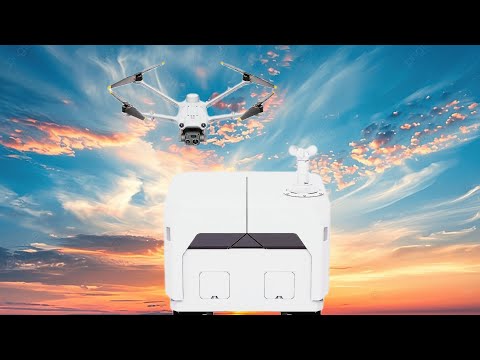
Automated Drone Operations are Taking Off: The DJI Dock 2, featured in one video, highlights the growing trend towards autonomous drone operations for mapping. This "drone-in-a-box" system simplifies complex workflows, enabling repeated flights with minimal human intervention, maximizing efficiency and data collection.
Best-in-Class Drones for Precision: Several videos from Dronefly showcase the top drones currently available for precision mapping and surveying tasks. This includes discussion of key features like high-resolution cameras, advanced sensors (including thermal and NDVI), and compatibility with different mapping software. Key players mentioned were DJI (Matrice 350, Mavic 3 Enterprise), Autel, and Anzu Robotics (Raptor).
Data Acquisition and Post-Processing Efficiencies: The videos emphasize the importance of post-processing software and workflow optimization for accurately transforming raw drone imagery into usable 3D models, elevation maps, and other geospatial data products. The discussions underscored the need for effective data management strategies, given the volumes of data generated during aerial surveys.
Soaring to New Heights: Future Trends in Drone Surveying
The convergence of advanced sensor technology, robust AI algorithms, and increasingly user-friendly software is driving a rapid evolution in drone surveying. We’re likely to see even greater autonomy, improved data accuracy (especially with centimeter-level precision), and more sophisticated analysis capabilities integrated directly into the drone platforms themselves. Furthermore, the development of specialized drones for niche applications (e.g., infrastructural inspections, precision agriculture, and disaster response) will continue at pace. The ability to combine drone data with other data sources (like LiDAR) to create incredibly detailed and comprehensive 3D models is a particularly exciting prospect.
Ready for Lift-Off?
This is just a glimpse into the exciting world of drone surveying and mapping. The videos highlighted above offer a more in-depth look at the latest innovations and their applications. Scroll down now to watch the key video highlights and prepare to be amazed by the possibilities!
Continue below to watch the videos
DJI DOCK 2: The Future of 3D Mapping DronesDJI pilot uk1,550 views | 157 | October 16 2024 16:16:45 (0 comments)[ Read more … ]
In this video, we’re taking a closer look at the DJI DOCK 2, a revolutionary drone system that’s changing the game for 3D mapping and aerial photography. With its innovative “drone in a box” design, the DJI DOCK 2 is perfect for commercial drones, surveying, and land use applications. By leveraging advanced GNSS and GPS technology, this drone is capable of capturing highly accurate topographic data, making it an essential tool for civil engineering, geographic information system (GIS), and lidar mapping projects. Whether you’re a professional surveyor or just starting out with drone photography, the DJI DOCK 2 is an exciting development that’s sure to elevate your workflow. Join us as we explore the features and capabilities of this cutting-edge system and discuss its potential to transform the world of aerial mapping and surveying.
For more information and the latest pricing, visit:
https://www.dronefly.com/
Check out https://www.dronefly.com for all of your enterprise drone needs!
🍁 𝐀𝐁𝐎𝐔𝐓 𝐃𝐑𝐎𝐍𝐄𝐅𝐋𝐘 🍁
Our channel is about industrial drones. Dronefly’s official YouTube channel is home to everything industrial drone (UAV). Showcasing tutorials, education, and use cases of aerial imaging with NDVI (agriculture), infrared (thermal), and zoom cameras.
🌟 𝐉𝐎𝐈𝐍 𝐃𝐑𝐎𝐍𝐄𝐅𝐋𝐘 🌟
https://www.youtube.com/channel/UCGZ-ZJ-j8SQHXTJYtNYa9vw/
🔔Don’t forget to subscribe!🔔
🎥𝐂𝐇𝐄𝐂𝐊 𝐎𝐔𝐓 𝐌𝐘 𝐎𝐓𝐇𝐄𝐑 𝐕𝐈𝐃𝐄𝐎𝐒🎥
➟ Anzu Raptor! – Overview | Dronefly
🔗https://youtu.be/xiCGcck2xbA
➟ DJI FlyCart 30 – Overview | Dronefly
🔗https://youtu.be/EX8F4dY086Y
➟ Autel EVO Lite Series Overview! | Dronefly
🔗https://youtu.be/JXhSl4lVN_k
Or check out our blog:
https://www.dronefly.com/blogs/
💌 𝐋𝐄𝐓’𝐒 𝐒𝐓𝐀𝐘 𝐈𝐍 𝐓𝐎𝐔𝐂𝐇 💌
Get updates or reach out to Get updates on our Social Media Profiles!
➟ Facebook:
🔗https://www.facebook.com/Dronefly/
➟ Twitter:
🔗https://twitter.com/dronefly?lang=en
➟ Instagram:
🔗https://www.instagram.com/dronefly/
Best Drones of 2024 – For Precision Mapping and Surveying | DroneflyDRONEFLY624 views | 17 | September 25 2024 02:29:57 (0 comments)[ Read more … ]
🌟In this video, Daniel gives you our top picks for the best precision mapping and surveying drones of 2024!
For more information and the latest pricing, visit:
https://www.dronefly.com/
Check out https://www.dronefly.com for all of your enterprise drone needs!
🍁 𝐀𝐁𝐎𝐔𝐓 𝐃𝐑𝐎𝐍𝐄𝐅𝐋𝐘 🍁
Our channel is about industrial drones. Dronefly’s official YouTube channel is home to everything industrial drone (UAV). Showcasing tutorials, education, and use cases of aerial imaging with NDVI (agriculture), infrared (thermal), and zoom cameras.
🌟 𝐉𝐎𝐈𝐍 𝐃𝐑𝐎𝐍𝐄𝐅𝐋𝐘 🌟
https://www.youtube.com/channel/UCGZ-ZJ-j8SQHXTJYtNYa9vw/
🔔Don’t forget to subscribe!🔔
🎥𝐂𝐇𝐄𝐂𝐊 𝐎𝐔𝐓 𝐌𝐘 𝐎𝐓𝐇𝐄𝐑 𝐕𝐈𝐃𝐄𝐎𝐒🎥
➟ Anzu Raptor! – Overview | Dronefly
🔗https://youtu.be/xiCGcck2xbA
➟ DJI FlyCart 30 – Overview | Dronefly
🔗https://youtu.be/EX8F4dY086Y
➟ Autel EVO Lite Series Overview! | Dronefly
🔗https://youtu.be/JXhSl4lVN_k
Or check out our blog:
https://www.dronefly.com/blogs/
💌 𝐋𝐄𝐓’𝐒 𝐒𝐓𝐀𝐘 𝐈𝐍 𝐓𝐎𝐔𝐂𝐇 💌
Get updates or reach out to Get updates on our Social Media Profiles!
➟ Facebook:
🔗https://www.facebook.com/Dronefly/
➟ Twitter:
🔗https://twitter.com/dronefly?lang=en
➟ Instagram:
🔗https://www.instagram.com/dronefly/
Best Drones of 2024 – For Precision Mapping and Surveying | DroneflyDRONEFLY509 views | 12 | September 23 2024 16:00:05 (0 comments)[ Read more … ]
🌟In this video, Daniel gives you our top picks for the best precision mapping and surveying drones of 2024!
For more information and the latest pricing, visit:
https://www.dronefly.com/
Check out https://www.dronefly.com for all of your enterprise drone needs!
🍁 𝐀𝐁𝐎𝐔𝐓 𝐃𝐑𝐎𝐍𝐄𝐅𝐋𝐘 🍁
Our channel is about industrial drones. Dronefly’s official YouTube channel is home to everything industrial drone (UAV). Showcasing tutorials, education, and use cases of aerial imaging with NDVI (agriculture), infrared (thermal), and zoom cameras.
🌟 𝐉𝐎𝐈𝐍 𝐃𝐑𝐎𝐍𝐄𝐅𝐋𝐘 🌟
https://www.youtube.com/channel/UCGZ-ZJ-j8SQHXTJYtNYa9vw/
🔔Don’t forget to subscribe!🔔
🎥𝐂𝐇𝐄𝐂𝐊 𝐎𝐔𝐓 𝐌𝐘 𝐎𝐓𝐇𝐄𝐑 𝐕𝐈𝐃𝐄𝐎𝐒🎥
➟ Anzu Raptor! – Overview | Dronefly
🔗https://youtu.be/xiCGcck2xbA
➟ DJI FlyCart 30 – Overview | Dronefly
🔗https://youtu.be/EX8F4dY086Y
➟ Autel EVO Lite Series Overview! | Dronefly
🔗https://youtu.be/JXhSl4lVN_k
Or check out our blog:
https://www.dronefly.com/blogs/
💌 𝐋𝐄𝐓’𝐒 𝐒𝐓𝐀𝐘 𝐈𝐍 𝐓𝐎𝐔𝐂𝐇 💌
Get updates or reach out to Get updates on our Social Media Profiles!
➟ Facebook:
🔗https://www.facebook.com/Dronefly/
➟ Twitter:
🔗https://twitter.com/dronefly?lang=en
➟ Instagram:
🔗https://www.instagram.com/dronefly/
Best Drones of 2024 – For Precision Mapping and Surveying | DroneflyDRONEFLY414 views | 11 | October 1 2024 19:00:31 (0 comments)[ Read more … ]
🌟In this video, Daniel gives you our top picks for the best precision mapping and surveying drones of 2024!
For more information and the latest pricing, visit:
https://www.dronefly.com/
Check out https://www.dronefly.com for all of your enterprise drone needs!
🍁 𝐀𝐁𝐎𝐔𝐓 𝐃𝐑𝐎𝐍𝐄𝐅𝐋𝐘 🍁
Our channel is about industrial drones. Dronefly’s official YouTube channel is home to everything industrial drone (UAV). Showcasing tutorials, education, and use cases of aerial imaging with NDVI (agriculture), infrared (thermal), and zoom cameras.
🌟 𝐉𝐎𝐈𝐍 𝐃𝐑𝐎𝐍𝐄𝐅𝐋𝐘 🌟
https://www.youtube.com/channel/UCGZ-ZJ-j8SQHXTJYtNYa9vw/
🔔Don’t forget to subscribe!🔔
🎥𝐂𝐇𝐄𝐂𝐊 𝐎𝐔𝐓 𝐌𝐘 𝐎𝐓𝐇𝐄𝐑 𝐕𝐈𝐃𝐄𝐎𝐒🎥
➟ Anzu Raptor! – Overview | Dronefly
🔗https://youtu.be/xiCGcck2xbA
➟ DJI FlyCart 30 – Overview | Dronefly
🔗https://youtu.be/EX8F4dY086Y
➟ Autel EVO Lite Series Overview! | Dronefly
🔗https://youtu.be/JXhSl4lVN_k
Or check out our blog:
https://www.dronefly.com/blogs/
💌 𝐋𝐄𝐓’𝐒 𝐒𝐓𝐀𝐘 𝐈𝐍 𝐓𝐎𝐔𝐂𝐇 💌
Get updates or reach out to Get updates on our Social Media Profiles!
➟ Facebook:
🔗https://www.facebook.com/Dronefly/
➟ Twitter:
🔗https://twitter.com/dronefly?lang=en
➟ Instagram:
🔗https://www.instagram.com/dronefly/
Best Drones of 2024 – For Precision Mapping and Surveying | DroneflyDRONEFLY209 views | 9 | October 3 2024 19:00:26 (3 comments)[ Read more … ]
🌟In this video, Daniel gives you our top picks for the best precision mapping and surveying drones of 2024!
For more information and the latest pricing, visit:
https://www.dronefly.com/
Check out https://www.dronefly.com for all of your enterprise drone needs!
🍁 𝐀𝐁𝐎𝐔𝐓 𝐃𝐑𝐎𝐍𝐄𝐅𝐋𝐘 🍁
Our channel is about industrial drones. Dronefly’s official YouTube channel is home to everything industrial drone (UAV). Showcasing tutorials, education, and use cases of aerial imaging with NDVI (agriculture), infrared (thermal), and zoom cameras.
🌟 𝐉𝐎𝐈𝐍 𝐃𝐑𝐎𝐍𝐄𝐅𝐋𝐘 🌟
https://www.youtube.com/channel/UCGZ-ZJ-j8SQHXTJYtNYa9vw/
🔔Don’t forget to subscribe!🔔
🎥𝐂𝐇𝐄𝐂𝐊 𝐎𝐔𝐓 𝐌𝐘 𝐎𝐓𝐇𝐄𝐑 𝐕𝐈𝐃𝐄𝐎𝐒🎥
➟ Anzu Raptor! – Overview | Dronefly
🔗https://youtu.be/xiCGcck2xbA
➟ DJI FlyCart 30 – Overview | Dronefly
🔗https://youtu.be/EX8F4dY086Y
➟ Autel EVO Lite Series Overview! | Dronefly
🔗https://youtu.be/JXhSl4lVN_k
Or check out our blog:
https://www.dronefly.com/blogs/
💌 𝐋𝐄𝐓’𝐒 𝐒𝐓𝐀𝐘 𝐈𝐍 𝐓𝐎𝐔𝐂𝐇 💌
Get updates or reach out to Get updates on our Social Media Profiles!
➟ Facebook:
🔗https://www.facebook.com/Dronefly/
➟ Twitter:
🔗https://twitter.com/dronefly?lang=en
➟ Instagram:
🔗https://www.instagram.com/dronefly/
Patryk Alexander is an associate copy editor at 4kVideoDrones.com, where he sharpens articles and helps keep the website's content clean and error-free. With a background in creative writing, Patryk brings a unique perspective to his editing that helps make 4kVideoDrones.com's content engaging and informative. When he's not editing or writing, Patryk enjoys spending time with his family and exploring the great outdoors.