
Drone Inferno: LA Wildfires & Aerial Destruction 🔥 – Key Insights for Wildfire Drone Operations
The recent "Drone Inferno" wildfires that ravaged Los Angeles serve as a stark reminder of the destructive power of nature and the complex airspace challenges that arise during such emergencies. These events, captured in dramatic detail across various YouTube channels, offer critical lessons for anyone involved in or interested in wildfire drone operations. From the devastating impact on communities to the critical importance of airspace awareness and safety protocols, these videos paint a vivid picture of the operational environment and underscore the need for responsible drone use. Let’s delve into the key takeaways from this aerial perspective.
Key Takeaways from the LA Wildfires
- The Devastation is Real and Visible: Videos like "Pacific Palisades neighborhoods destroyed by California fires" and "Drone footage shows scorched LA neighbourhood after wildfires" provide a sobering aerial view of the sheer scale of destruction. We see entire neighborhoods reduced to ash, highlighting the urgent need for effective wildfire management and the potential role of drones in damage assessment and recovery efforts. The visual impact underscores the importance of rapid and accurate information gathering in the aftermath of such events.
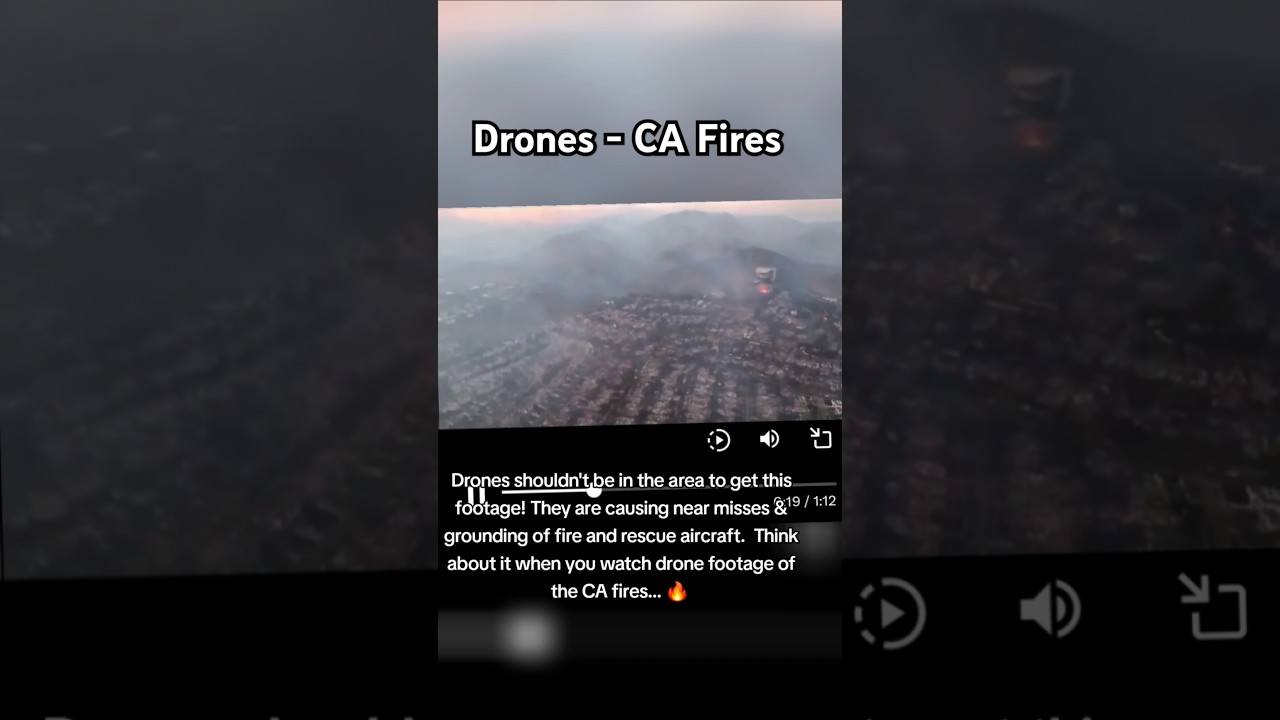
- Unauthorized Drone Operations Pose a Significant Hazard: The alarming video "Drone hits Super Scooper fighting California fires" serves as a critical case study in the dangers of irresponsible drone operation. The mid-air collision with a Super Scooper, a vital aircraft in wildfire suppression, not only grounded the water bomber but also put lives at risk. This incident vividly illustrates the potential for catastrophic consequences when drones are flown without proper authorization or situational awareness in active fire zones. The ongoing FAA and FBI investigation highlights the seriousness of such airspace violations.
- Drones Provide a Unique Perspective for Situational Awareness: While unauthorized drone flights are dangerous, the footage captured in videos like "WATCH: Drone Captures Harrowing Destruction From LA Fires After Entire Neighborhoods Are Destroyed" and "Drone video shows wildfire devastation in Pacific Palisades" demonstrates the invaluable perspective drones can offer. These aerial views provide critical insights into fire behavior, the extent of damage, and the overall operational picture for first responders and emergency management teams. The ability to quickly assess the situation from above is crucial for effective resource allocation and strategic decision-making.
- Public Interest and Media Coverage are High: The significant view counts and engagement on videos like "Pacific Palisades neighborhoods destroyed by California fires" and "Drone footage shows scorched LA neighbourhood after wildfires" indicate a strong public interest in understanding the impact of these wildfires. This highlights the role of drones in documenting and disseminating information about these events, but also underscores the need for responsible and ethical use of drone technology in such sensitive situations.
- Even Short Drone Flights Can Capture Significant Information: The "#shorts" video "Drone footage shows aftermath of wildfire devastation in Los Angeles | #shorts #wildfire" demonstrates that even brief drone deployments can yield valuable visual data. This is particularly relevant in rapidly evolving situations where quick assessments are crucial.
Analyzing the Drone Collision: A Critical Safety Lesson
The incident involving the drone and the Super Scooper is a stark reminder of the non-negotiable importance of airspace awareness and adherence to regulations during wildfire operations. From a pilot’s perspective, encountering unauthorized drones in an active fire zone is a nightmare scenario. These areas are already complex and hazardous, with multiple aircraft operating in close proximity, often in challenging weather conditions and reduced visibility due to smoke.
The potential consequences of such collisions are severe:
- Damage to Manned Aircraft: Even a small drone can cause significant damage to an aircraft, potentially leading to loss of control or engine failure. In the case of a Super Scooper, this could severely impact firefighting efforts and endanger the crew.
- Risk to Human Life: A collision could lead to the crash of either the drone or the manned aircraft, resulting in serious injury or fatality.
- Disruption of Firefighting Operations: Grounding a vital firefighting asset like a Super Scooper hinders the ability to contain the blaze, potentially leading to further property damage and environmental impact.
This incident underscores the need for:
- Strict Enforcement of No-Fly Zones: Temporary Flight Restrictions (TFRs) are put in place around wildfires for a reason. Violating these restrictions is not only illegal but also incredibly dangerous.
- Public Education: Raising awareness among recreational drone users about the dangers of flying near wildfires and the importance of checking for TFRs before every flight is crucial.
- Advanced Drone Detection Technology: Exploring and implementing technologies that can detect and track unauthorized drones in sensitive airspace can provide early warnings and allow for preventative measures.
Moving Forward: Ensuring Safe and Effective Wildfire Drone Operations
The "Drone Inferno" serves as a powerful learning experience. While the destructive potential of wildfires is undeniable, the videos also highlight the potential for drones to contribute positively to wildfire management – from providing critical situational awareness to aiding in damage assessment. However, realizing this potential hinges on a commitment to safety, responsible operation, and a thorough understanding of the airspace environment.
As drone pilots and instructors, we must emphasize the following best practices:
- Prioritize Safety Above All Else: Never fly in or near active fire zones without explicit authorization and a clear understanding of the operational environment.
- Thorough Pre-Flight Planning: Always check for Temporary Flight Restrictions (TFRs) and NOTAMs before any flight. Utilize resources like the FAA’s B4UFLY app.
- Maintain Visual Line of Sight: Unless operating under specific waivers, maintain visual line of sight with your drone at all times.
- Understand Airspace Regulations: Be fully aware of the regulations governing drone operations in your area.
- Effective Communication: If authorized to operate in a fire zone, maintain clear communication with air traffic control and other aerial assets.
By adhering to these principles, we can ensure that drones are used safely and effectively in wildfire management, contributing to the protection of lives, property, and the environment. Scroll down to see the video highlights that underscore these critical lessons.
Check out the videos below


