The Sky’s the Limit: Drone Surveying Takes Topography to New Heights
The rumble of a job site, the vast expanse of undeveloped land – these are the canvases upon which construction and land management projects are built. But before the first bulldozer rolls or the foundation is laid, accurate topographic data is paramount. For decades, boots-on-the-ground surveying teams meticulously mapped terrains. Now, a revolution is taking place overhead. Drones, equipped with increasingly sophisticated sensors and cameras, are transforming topographic surveying, offering speed, precision, and accessibility previously unimaginable. The following video highlights offer a glimpse into this exciting evolution, showcasing everything from essential equipment and flight strategies to real-world project applications and cost-saving techniques. Prepare to see how aerial mapping is not just changing the game, but elevating it.
Key Insights from the Drone Surveying Front Lines
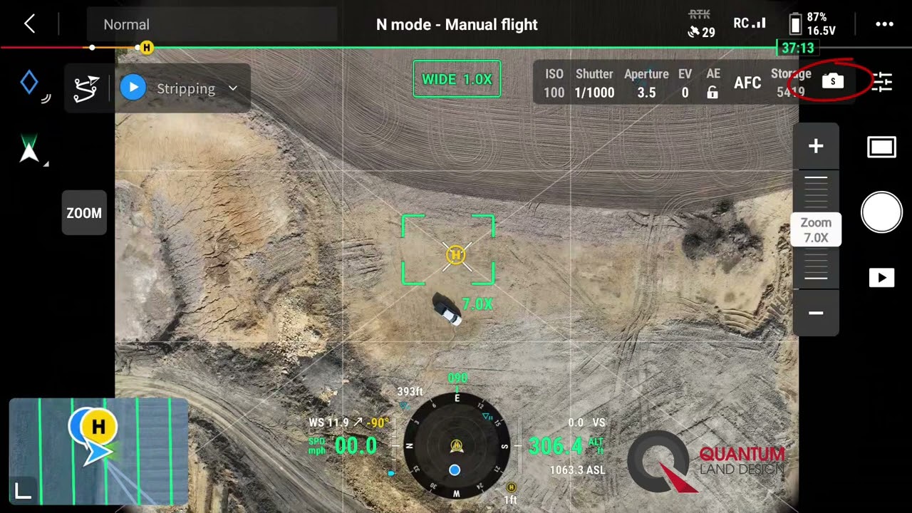
Precision Camera Settings are Mission Critical: For accurate topographic mapping, especially in dynamic environments like earthmoving and quarry sites, optimizing drone camera settings is non-negotiable. As demonstrated in the "DJI Mavic 3E Camera Settings for Topographic Survey Mapping" video, understanding and implementing the correct settings in software like DJI Pilot 2 ensures data collection is optimized for volume calculations, stockpile assessments, and integration with machine control systems. This level of precision directly impacts project efficiency and cost management.
GNSS Receivers: The Cornerstone of Centimeter Accuracy: Achieving survey-grade accuracy with drones hinges on precise positioning. The "#1 MUST HAVE Drone Surveying Tool 🧰" video emphasizes the crucial role of multi-band RTK GNSS receivers like the Emlid Reach RS2+. These tools, whether used as rovers, base stations, or in pairs for on-site corrections, provide centimeter-level precision. Coupled with Ground Control Points (GCPs), they significantly enhance the reliability of photogrammetry and LiDAR data, making them indispensable for professional surveying, mapping, and construction applications. Think of it as laying a solid geodetic foundation for your aerial maps.
LiDAR’s Power for Large-Scale, Rapid Data Acquisition: When time is of the essence and large areas need to be surveyed, LiDAR steps into the spotlight. "What Does A $350K LiDAR Project REALLY Look Like?" offers a compelling case study of a 750-acre project completed in under 12 hours, with deliverables in just 2-3 weeks. This video underscores the speed and efficiency gains possible with LiDAR technology, especially when paired with robust platforms like the DJI M300 RTK and flight planning software like UGcS. While the initial investment in LiDAR can be substantial, the return in time savings and project turnaround for large-scale operations can be transformative.
Mapping Capabilities are Expanding to Accessible Drones: High-quality drone mapping is no longer exclusive to top-tier, expensive equipment. "Map for Free with a DJI Mini 3 Pro!" demonstrates that even consumer-grade drones, when used strategically, can produce valuable mapping data without incurring additional software costs. This accessibility opens doors for smaller projects and firms to leverage drone surveying, highlighting the democratization of this technology and its expanding reach within the industry.
Beginner-Friendly Approaches to Topographic Surveying: The learning curve for drone surveying is becoming increasingly manageable. "A Beginner’s Guide To Topographic Surveying With Drones" provides a clear roadmap for newcomers, covering essential equipment, step-by-step workflows, and data processing tips. By demystifying the process and outlining practical steps, these resources empower a wider range of professionals – from land surveyors to engineers – to adopt drone-based methods and enhance their skillsets.
Drone Surveying Streamlines Construction Workflows: The integration of drone surveying into construction is revolutionizing project management. "Drone Surveying for Construction – Photogrammetry & Mapping" showcases how automated drone flights, coupled with photogrammetry, deliver precise 2D maps and 3D models that meet industry accuracy standards (ASPRS). This translates to streamlined construction monitoring, proactive issue detection, reduced man-hours, and enhanced data-driven decision-making. The seamless integration with existing software and tools further solidifies drones as a core component of modern construction workflows.
The Future is Vertical: Efficiency, Accuracy, and Accessibility Define the Trajectory
Looking ahead, the trend is clear: drone surveying is not just a niche application, but a rapidly evolving standard practice. We’re seeing advancements in sensor technology driving even greater accuracy and detail in aerial data. Software is becoming more intuitive and automated, simplifying data processing and analysis. Crucially, the increasing accessibility of drone technology, both in terms of cost and ease of use, is empowering a broader range of professionals to integrate aerial mapping into their workflows. The construction and land management sectors are poised to benefit immensely from these advancements, experiencing gains in efficiency, accuracy, and project insights that were once considered aspirational.
Take Flight with Drone Surveying Knowledge
Ready to delve deeper into the specifics of drone surveying and witness these transformative techniques in action? Scroll down to explore the video highlights and take your understanding of topographic mapping to a whole new altitude.
The curated videos await below
DJI Mavic 3E Camera Settings for Topographic Survey MappingQuantum Land Design17,158 views | 108 | April 21 2023 14:56:25 (13 comments)[ Read more … ]
Easy to follow camera settings to fly topographic survey missions with your Quantum Flight Pack. These flight settings are optimized for the Mavic 3E drone to collect data on an earthmoving or quarry site.
Fly your sites to determine earthwork volume calculations, stockpile calcs even calculate production in conjunction with your GPS machine control system.
We are showing DJI Pilot 2 on a Mavic 3 Enterprise (M3E) here. In general, the same settings will apply to any DJI drone with mapping capabilities.
Free machine control and drone data resources – www.quantumlanddesign.com/education
0:09 1. The receiver can be configured as a rover setup. 0:19 2. It’s compatible as an RTK base station. 0:31 3. Easily connect two RS2+ units for on-site corrections data 0:41 4. Tough and lightweight for challenging environments 0:48 5. Collection of all types of drone data, photogrammetry, LiDAR, orthomosaics, and more.
In addition, using a receiver like this with centimeter precision in conjunction with Ground Control Points (GCPs) can significantly improve the accuracy and reliability of drone-based Photogrammetry, LiDAR, and survey-grade collection. The Multi-band RTK GNSS receiver is a must-have tool for professionals in surveying, mapping, and construction. Its exceptional accuracy and versatility make it an invaluable asset for a wide range of drone mapping applications, ultimately enhancing productivity and the quality of results.
►About The Drone Life The Drone Life is an industry-leading UAS service provider that provides turnkey aerial data solutions nationwide. We proudly specialize in the industrial, environmental, renewable, and construction industries. Our team consists of highly experienced, dependable, and licensed drone professionals that are committed to safety, quality, and customer success.
What Does A $350K LiDAR Project REALLY Look Like?Dylan Gorman245,365 views | 5,869 | September 10 2022 17:00:03 (443 comments)[ Read more … ]
What do you get when you pair a turnkey LiDAR solution and a client that is looking to have an aerial survey completed in 2-3 weeks rather than 2-3 months? This $350,000 LiDAR project I just completed is exactly what ended up happening with my client and me. Check this video out to learn how I was able to capture 750 acres of land in less than 12 hours and provide deliverables to my client in 2-3 weeks’ time from initial data capture!
Thank you Rock Robotic for sponsoring this video! Harrison and his team over at Rock Robotic are a great group of people with a fantastic product and a killer support system to get you up and running with aerial LiDAR quickly.
Learn more about Rock Robotic here: https://www.rockrobotic.com/
►Resources/ Equipment used Rock R2A LiDAR: https://www.rockrobotic.com/drone-lidar-hardware-r2a Emlid RS2 GNSS: https://emlid.com/reachrs2plus/ DJI M300 RTK: https://www.dji.com/matrice-300 DJI D-RTK 2 GNSS: https://www.dji.com/d-rtk-2 UGcS Flight Planning Software: https://www.ugcs.com/ — ► Looking to Fast Track your way to a career in the commercial drone industry? Join many others who have taken this private 4-week mentorship program and see how you can get flying: https://www.pilotbyte.com/course/4-week-private-mentorship-program
►Drones used in the drone industry: 1) “Beginner” – DJI Mini 2: https://amzn.to/3MwY7GO 2) “Beginner” – DJI Air 2s: https://amzn.to/3s2TVGO 3) “Advanced” – DJI Mavic 2 Pro: https://amzn.to/3B2cGhv 4) “Advanced” – DJI Phantom 4 Pro: https://amzn.to/3B7eAx7 5) “Intermediate” – DJI Inspire 2: https://amzn.to/38EerXp 6) “Intermediate” – DJI Mavic 3: https://amzn.to/3LAK3vO
► Subscribe to my channel here: https://www.youtube.com/c/dylangorman — My Camera Equipment! Canon R5: https://amzn.to/36YsAP1 Canon 24-70 2.8L: https://amzn.to/2S2KVCK Rode Microphone: https://amzn.to/3pfokiM Drone: https://amzn.to/3x9GHLW __ Follow me online!
LinkedIn: https://www.linkedin.com/in/dylan-g-099961101/ Instagram: https://www.instagram.com/dylang_1 — Chapters 00:00 Intro 00:48 Why am I capturing LiDAR for this project? 02:35 Equipment/ software overview 03:44 Setting ground controls 04:42 Rock Robotic 06:12 Flight planning w/ google 08:33 Mission automation with UGcS 09:44 In-field data capture 11:44 Data processing 14:18 Analyzing the data 15:57 Processed data review 16:46 Conclusion
Map for Free with a DJI Mini 3 Pro!Pilot Institute88,284 views | 2,338 | May 31 2024 17:00:11 (207 comments)[ Read more … ]
Jared shows how you can make a quality map with a drone. All without spending a single dollar!
New LiDAR course out now: https://pilotinstitute.com/course/drone-lidar/
00:00 Introduction 00:27 Getting Started With Mapping 03:22 Planning the Mission 06:23 Ready to Fly 09:20 Processing 11:48 Viewing the Map
Join our community site: community.pilotinstitute.com
Check out our gear list: https://www.amazon.com/shop/pilotinstitute
Our Other Channel – Pilot Institute Airplane: our airplane channel: https://www.youtube.com/channel/UCIgBjGoM-yn_3bH8Qr9xkXA
Our courses – Part 107 Made Easy: the most comprehensive ground school online. https://bit.ly/2AkRWq0 – Drone Business Made Easy: start your drone business with a solid foundation. https://bit.ly/3dVT55T – Drone Flying 101: the perfect course for beginners. https://bit.ly/2XUy3Pc – Drone Maneuvers Mastery: become a better pilot with these 50 maneuvers designed to improve your flying skills. https://bit.ly/3hkWkG3 – Cinematic FPV Drone From Scratch: build your own cinematic machine with this course. https://bit.ly/37oOfeG
Get Pilot Institute Gear: https://merch.pilotinstitute.com
Advertisement
A Beginner’s Guide To Topographic Surveying With Drones | UAV Mapping Made Easy.Nexxis Tutorials455 views | 18 | February 10 2025 12:01:16 (4 comments)[ Read more … ]
🚁 Ready to revolutionize your surveying skills? In this beginner’s guide, we’ll show you how to use drones for topographic surveying like a pro!
Learn the basics of drone mapping, essential equipment, step-by-step workflows, and tips to create accurate 3D maps and models.
Whether you’re a land surveyor, engineer, or just curious about drone technology, this video will help you get started with topographic surveying the smart way.
🔔 Hit the bell icon to stay updated on our latest videos!
Advertisement
Drone Surveying for Construction – Photogrammetry & MappingThe Drone Life7,416 views | 196 | September 12 2023 20:17:29 (0 comments)[ Read more … ]
Claim Your FREE GUIDEBOOK to Using Drones in Construction 👇 https://bit.ly/42MY2b9
Discover the future of the AEC industry with drone mapping and photogrammetry solutions in our latest video! Learn how automated drone flights are revolutionizing data collection, meeting ASPRS accuracy standards, and streamlining construction monitoring. From precise 2D maps to 3D models, our versatile drone-based photogrammetry covers a wide range of applications, reducing man-hours and enabling proactive issue detection.
With seamless software integration and compatibility with existing tools, you can enhance data analysis and visualization. Embrace unprecedented efficiency and accuracy while harnessing actionable insights for informed decision-making. If you’re ready to implement drone solutions, The Drone Life’s experienced, licensed, and OSHA-certified pilots are here to assist you. Visit thedronelifenj.com for more information and consultation with our experts!
►Resources The Ultimate Beginner’s Guide to Drone Photogrammetry https://thedronelifenj.com/drone-photogrammetry-beginner-guide/
►Our Must-Have Drone Equipment Checklist ✅ Budget Friendly Ground Control Points (GCPs) – http://bit.ly/3nAT2pH ✅ Drone Mapping RTK Base & Rover GNSS Reciever – https://bit.ly/3Jo526a ✅ Most Reliable SD Card for Drone Mapping – http://bit.ly/3lZOhWn ✅ Heavy Duty Landing Pad – http://bit.ly/3zt1hXA ✅ Collapsable Orange Safety Cones – http://bit.ly/40Tr2fp ✅ OSHA Certified Safety Vest -http://bit.ly/3KsycSt ✅ Wind Speed Anemometer Gauge – http://bit.ly/3ZCaYO5 ✅ Best Flight Planning Tablet – http://bit.ly/40Dci4q ✅ Handheld VHF Airband Transceiver – http://bit.ly/40AyLPP
►About The Drone Life The Drone Life is an industry-leading UAS service provider that provides turnkey aerial data solutions nationwide. We proudly specialize in the industrial, environmental, renewable, and construction industries. Our team consists of highly experienced, dependable, and licensed drone professionals that are committed to safety, quality, and customer success.
Patryk Alexander is an associate copy editor at 4kVideoDrones.com, where he sharpens articles and helps keep the website's content clean and error-free. With a background in creative writing, Patryk brings a unique perspective to his editing that helps make 4kVideoDrones.com's content engaging and informative. When he's not editing or writing, Patryk enjoys spending time with his family and exploring the great outdoors.