Dronelink Automation ✈️: Automating Flight Paths & Data Capture
Ready to take your drone flights to the next level? These videos dive into the world of Dronelink automation, revealing how this powerful software can transform your data capture missions. From automated mapping with the DJI Mini 3 to complex cell tower inspections, we’ll explore the versatility of Dronelink across various platforms and applications. We’ll unpack the core features, workflows, and even touch on integration with other powerful tools like WebODM for processing your captured data. Whether you’re a seasoned pilot or just starting out, this collection offers valuable insights into optimizing your workflows and unlocking the full potential of your drone.
Key Takeaways: Dronelink Powers Up Your Drone Missions
Mini 3 Gets Smart: The DJI Mini 3, now with SDK support, seamlessly integrates with Dronelink, opening up a world of automated photogrammetry, mapping, and other data capture possibilities for this compact powerhouse. We see real-world examples of how easy it is to plan and execute missions, showcasing the practical applications of this newly enabled functionality.
Mastering Dronelink Flight Control: The core functionalities of Dronelink are put on display – from pre-planned missions to on-the-fly adjustments and various flight modes like orbit and follow. We learn about 3D flight path previews, mission estimations, and how Dronelink streamlines operations across multiple devices.
Data Capture & Processing Synergy: The videos highlight how Dronelink integrates with powerful processing tools like WebODM Lightning. We see a practical walkthrough of a combined mapping and facade mission, culminating in the generation of orthomosaics, point clouds, and 3D models. This illustrates a complete workflow, from flight planning to data analysis.
Streamlined Mobile Missions: The Dronelink mobile app becomes your command center. We explore the flight dashboard – managing camera settings, creating and resuming missions, adjusting layouts, and handling crucial settings like RTH altitude. This emphasizes the flexibility and control offered by the mobile platform.
Scaling Up for Industry: The Scanlink workflow demonstrates how Dronelink is revolutionizing professional applications, specifically cell tower inspections. We see how easy it is for even novice pilots to capture high-quality data for digital twinning, emphasizing the efficiency and scalability of Dronelink in a commercial setting.
The integration of Dronelink with platforms like WebODM and SiteSee showcases a trend toward streamlined workflows and powerful data analysis. This signifies a shift beyond simply automating flight paths and into a more holistic approach to drone operations. Expect to see further development in areas like automated data processing, AI-powered analysis, and industry-specific solutions. The combination of Dronelink’s flight control capabilities with these advanced processing tools unlocks powerful new possibilities for various industries.
Elevate Your Drone Game: Explore the Possibilities
This collection of videos provides a comprehensive overview of Dronelink’s capabilities, from basic mapping missions to complex industrial applications. Scroll down to watch the highlights and discover how you can leverage Dronelink to automate your workflows, enhance data capture, and take your drone operations to the next level!
Swipe down to view the videos
The DJI Mini 3 Just Got BETTER | DJI Mini 3 PhotogrammetryDylan Gorman196,056 views | 4,029 | April 22 2023 16:30:06 (412 comments)[ Read more … ]
The DJI Mini 3 has finally received its long-awaited SDK support which now allows it to work with 3rd party software. Unleash the potential of this compact powerhouse for industries like aerial photogrammetry, agriculture, and more. Watch as we demonstrate the versatility of the DJI Mini 3, showcasing its first 3rd party app integration, and offering insights into the future of drone technology.
—
► Join us on Pilot Byte! Our platform provides current and aspiring drone operators with information and resources to promote growth and development in the drone industry: https://www.pilotbyte.com
► Subscribe to my channel here: https://www.youtube.com/c/dylangorman
—
My Camera Equipment!
Canon R5: https://amzn.to/36YsAP1
Canon 24-70 2.8L: https://amzn.to/2S2KVCK
Rode Microphone: https://amzn.to/3pfokiM
Drone: https://amzn.to/3x9GHLW
__
Follow me online!
LinkedIn: https://www.linkedin.com/in/dylan-g-099961101/
Instagram: https://www.instagram.com/dylang_1
—
Chapters
00:00 Intro
01:03 Mini 3 SDK Support
01:42 What you need to fly automated missions
02:42 Mission planning with Mini 3
05:11 Air2s Giveaway & Virtual Workshop Info
06:08 Automated data capture with Mini 3
07:57 Processed Mini 3 data review
11:19 Key takeaways
12:08 Outro
DJI Mini 3, Mini 3 Mapping, Mini 3 Photogrammetry, Mini 3 Pro, Mini 3 Pro Mapping, Mini 3 Pro Photogrammetry
Advertisement
Dronelink Flight Control – Automated Missions, Workflows and Flight ToolsDronelink30,949 views | 99 | July 12 2023 18:56:09 (18 comments)[ Read more … ]
Fly missions for maps, waypoints, vertical mapping, or inspections; or use flight modes such as orbit, follow, or focus.
Flight control for leading drones from DJI and Autel, including Mini, Air, and Mavic series drones.
Supported on web, iOS, Android, and on Remote Controllers.
Trusted by pilots globally for automating flight and data capture for any use case and industry.
Choose between multiple workflows:
Plan missions on any device and configure every detail.
Generate missions on-the-fly in the field, using the position of the drone.
Use flight modes and make real-time adjustments.
Explore the flight path in 3D before flying, get mission estimates, and preview the mission by flying a virtual drone.
Missions are synchronized across devices and ready to fly, open a mission to start it, pause and resume at any time.
Customize the flight dashboard to show the details you need.
Use the management dashboard to organize missions, enable integrations, and track flights for one or multiple pilots.
List of supported drones:
https://www.dronelink.com/supported-drones
00:00 – Fly missions for maps, waypoints, vertical mapping, inspections
00:13 – Use flight modes such as orbit, follow, focus
00:26 – Multiple Workflows – Plan, On-the-fly, Modes
00:51 – 3D Mission Preview and Estimates
01:02 – Open, Start, Pause and Resume Missions
01:10 – Flight Dashboard
01:15 – Manage Operations
Advertisement
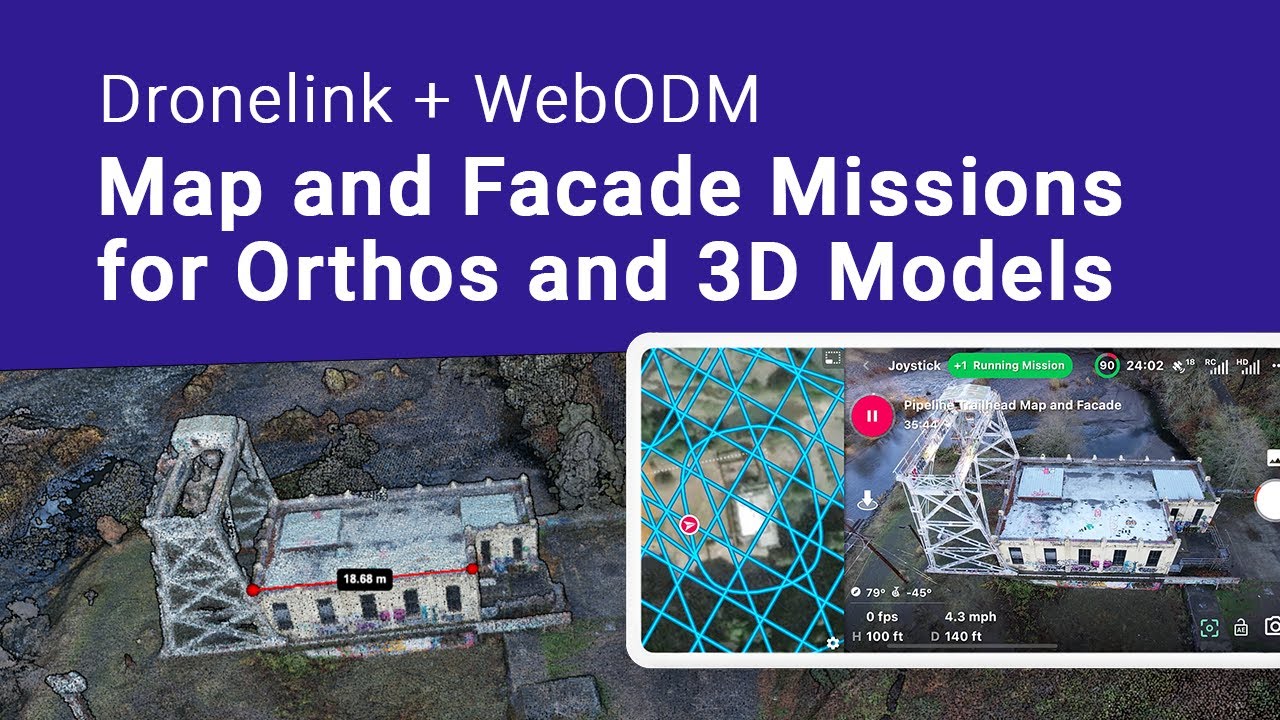
Fly a Mapping and Facade Mission to Create Orthos and 3D Models with WebODM LightningDronelink14,835 views | 199 | December 13 2022 17:26:00 (10 comments)[ Read more … ]
Learn how to create and fly a combined mapping and facade mission with Dronelink, to capture data autonomously, for processing into orthomosaics, point clouds and 3D models with WebODM Lightning. View data output with QGIS and CloudCompare.
Deals for WebODM and Dronelink:
WebODM Lighting users get 20% off Dronelink Professional Plans.
Dronelink Users get 1000 free processing credits with WebODM Lighting.
Redeem Promo and Discount here:
https://dronelink.com/webodm
Dronelink allows you to create mission plans with maps, facades (vertical maps), waypoints, obits and more to automate flight and data capture with the most popular drones.
See supported drones here:
https://support.dronelink.com/hc/en-us/articles/360025829933-What-are-the-system-requirements-
0:00 – Intro
00:24 – Map Mission Planning
00:39 – Continue Mission Planning in Mobile
01:00 – Duplicate Map and Setup Crosshatch for better 3D models
01:12 – Add Facade Missions around Structures
01:36 – 3D Mission Preview
01:51 – Fly Mission to Capture Data and Resume after Battery Swap
02:15 – Upload to WebODM Lightning for Processing
02:34 – Download and Review Processing Output Files
03:08 – Open Maps and Models in QGIS and CloudCompare
Advertisement
Dronelink Flight Dashboard – Fly and Create Missions, Resume Missions, Manage SettingsDronelink7,357 views | 91 | September 5 2022 11:16:56 (35 comments)[ Read more … ]
Fly mission plans autonomously using the Dronelink mobile app. Learn how to use the Dronelink mobile app to open existing missions, create new ones, manage key settings, resume missions and more.
After connecting a drone, explore how to change camera settings within the Flight Dashboard, open on-the-fly missions or existing mission plans with the quick access menu, start a mapping mission and adjust the app layout, and pause and resume the mission until it has been accomplished.
View where to change key settings, such as unit system, RTH altitude, format the SD card, calibrate the gimbal, and options for editing existing mission plans, downloading them for offline use, and creating new missions.
Dronelink’s Flight Dashboard can be used to fly manually, even without a Dronelink account, however an account is required to create and fly autonomous missions.
0:00 – Intro
00:14 – Home Screen – Connect Drone
00:30 – Open Flight Dashboard and Change Camera Settings
01:10 – Quick Access Menu
01:47 – Open and Start a Mission Plan
02:09 – Map Preview Options
02:31 – Change Flight Dashboard Layout
03:11 – Pause and Resume Mission
03:39 – Open a Incomplete Mission
03:54 – Mission Accomplished and RTH
04:20 – Managing Settings
04:46 – Multiple Flight Statuses
05:00 – General App Settings
05:14 – Create New Mission Plans
05:25 – Edit, Preview, Offline Existing Mission Plans
Advertisement
Cell Tower Digital Twinning with Scanlink by Telecom Service Techs at QNSI with SiteSee & PhilTowerDronelink2,770 views | 54 | November 11 2023 00:39:20 (10 comments)[ Read more … ]
QNSI, is a telecom service provider in the Philippines, that has partnered with Dronelink for cell tower flight automation, and SiteSee, for data processing and analytics, to digitally twin over 700 towers in 6 months for PhilTower, a TowerCo taking the lead in adopting drones and AI to enhance their business.
Using Scanlink, a scalable cell tower capture solution by Dronelink, QNSI was able to quickly train over 20 service technicians that were new to drones, and seamlessly integrate drones as another tool in the box, allowing them support the industry’s digital transformation drive, and improve the safety and efficiency of their work.
In Scanlink, a simple step-by-step workflow guides pilots to mark key tower inputs using the drone on site, which generates an optimized mission that is required for creating high quality 3D models.
The captured data is uploaded to SiteSee’s telecom digital twinning and AI platform, that converts the captured data, into a single source of truth for TowerCOs, to improve asset management workflows, accelerate revenue generation, reduce costs with fewer truck rolls and faster audits, and improve inspections and loading analysis.
Learn more here:
https://www.dronelink.com/use-cases/cell-towers
00:00 – Use Case Intro
00:38 – Scanlink Quick Overview – Cell Tower Capture Solution
00:57 – SiteSee Processing and Digital Twin Benefits for TowerCOs
01:24 – Scanlink Setup – Main Steps
02:23 – Marking Obstacles – Optional Step
02:53 – Generated Mission and 3D Preview
03:14 – Start and Fly Mission
04:14 – Monitoring Operations
Advertisement
Mapping for DJI Mini 3 Pro- Dronelink Beta- Part 3- Mapping with Maps Made EasyShawn Williams 1,887 views | 55 | June 1 2023 04:00:26 (10 comments)[ Read more … ]
Part 3, we are back at the computer to add the images to Maps Made Easy. This cloud software will take all of our images and stitch them together to create a centralized map.
Watch part 1 here: https://www.youtube.com/watch?v=1A__J4uNZ_M
Watch part 2 here: https://www.youtube.com/watch?v=ayohUQuGRLo
🔥 Grab The DJI Mini 3 Pro On Amazon Here:https://amzn.to/425imCE
🔥 Grab the android phone I see in the video: https://amzn.to/3OWXZ87
🔥 Dronelink website: https://www.dronelink.com
📸 GEAR I USE ⬇️
Computer I edit with: https://amzn.to/3IMnEfZ
Camera I use to film: https://amzn.to/3ILrUfE
As an amazon affiliate I earn from qualifying purchases and I would appreciate any support 🤘
Patryk Alexander is an associate copy editor at 4kVideoDrones.com, where he sharpens articles and helps keep the website's content clean and error-free. With a background in creative writing, Patryk brings a unique perspective to his editing that helps make 4kVideoDrones.com's content engaging and informative. When he's not editing or writing, Patryk enjoys spending time with his family and exploring the great outdoors.