Unleash your drone's mapping power! Free software unlocks pro-grade results. Capture detailed aerial data efficiently & cost-effectively. Click to learn more!
Unleash the Power of Free: Revolutionizing Your Mapping & Surveying with Drone Technology 🗺️
As a seasoned drone pilot and instructor, I’ve witnessed firsthand the transformative impact of drone technology across various industries. For those in mapping and surveying, the ability to capture highly detailed aerial data efficiently and cost-effectively has been a game-changer. What’s even more exciting is the growing availability of Free Drone Mapping Software, opening up these powerful capabilities to a wider range of professionals and projects. Forget expensive proprietary software and hefty subscription fees – the videos below highlight how you can leverage freely available tools to create professional-grade outputs. Think of it: the precision of aerial data, the efficiency of automated flight, all processed with software that won’t break the bank. This isn’t just about saving money; it’s about democratizing access to cutting-edge technology and empowering you to deliver superior results. Let’s delve into the key insights from these informative YouTube resources and see how you can turn your drone into a powerful mapping machine.
Key Takeaways: Free Drone Mapping Software in Action
Transform Your DJI Drone into a Mapping Powerhouse (Without the Price Tag): Video 1, "Turn Your DJI Drone Into A Mapping Machine For FREE!", clearly demonstrates that popular DJI models like the Mavic 3, Air 3, and Mini 4 Pro can be utilized for serious mapping tasks without needing paid software. This opens up significant possibilities for leveraging existing equipment. The focus on autonomous mission planning within the DJI Fly app, coupled with free processing software, is a practical and efficient approach for many operators. Imagine programming a precise flight path, your drone diligently capturing the necessary imagery, all without complex third-party applications.
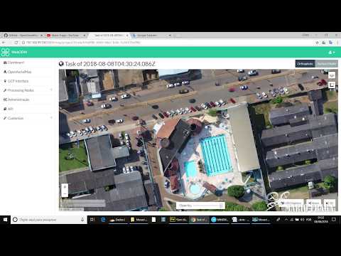
WebODM: A Free and Open-Source Solution for DJI Mini 2 (and Beyond): Video 2, "Free DJI Mini 2 Drone Mapping with WebODM Overview," shines a light on the power of WebODM, a free and open-source platform. This video highlights the feasibility of using even a smaller drone like the DJI Mini 2 for mapping, showcasing impressive results from manually flown missions in challenging winter conditions. The key takeaway here is the accessibility and capability of WebODM to process imagery into valuable outputs like orthomosaics and 3D models. For realtors, as the video suggests, this presents a compelling, cost-effective way to showcase properties and their surroundings.
The DJI Mini 3 Gets Smarter with SDK Support: Video 3, "The DJI Mini 3 Just Got BETTER | DJI Mini 3 Photogrammetry," underscores the significance of SDK (Software Development Kit) support. The availability of SDK access for drones like the Mini 3 unlocks the potential for integration with various third-party applications, expanding its utility for professional tasks like photogrammetry. This means more flexibility in mission planning and data capture, crucial for achieving the accuracy and detail required in surveying applications. The ability to fly automated missions with a compact drone like the Mini 3 is a significant step forward.
Enhance Your Photogrammetry with Pre-Processing Techniques: Video 4, "ONE Trick to Improve Your Photogrammetry," provides valuable practical advice for improving the quality of your mapping outputs. It emphasizes that even with free software, the quality of the input data is paramount. The video effectively demonstrates how using free image editing tools like RawTherapee to adjust shadows and highlights can significantly enhance the accuracy of point clouds, the detail in orthomosaics, and the alignment of 3D models. This is a crucial step in ensuring the reliability and usability of your final mapping products. Thinking about a heavily shadowed construction site? Applying these techniques can unveil critical details otherwise lost.
DIY 3D Modeling with Free Software: Meshroom and Blender: Video 5, "DJI Mini 2 | Make a 3D Model for free with drones," dives into the realm of 3D modeling using completely free software like Meshroom and Blender. This is a powerful demonstration of how to create visually rich and informative 3D models without incurring software costs. Imagine inspecting a building façade or analyzing terrain – these free tools provide the means to generate detailed, textured models from your drone imagery.
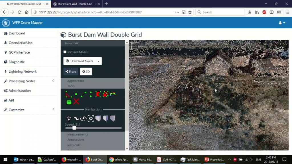
WebODM: A Foundation for Free Drone Image Processing: Video 6, "Open Drone Map – WebODM – Plataforma para Processamento de Imagens de Drone – Free – Open Source," (while in Portuguese, the core message is clear) further reinforces the role of WebODM as a user-friendly and extensible platform for drone image processing. The emphasis on generating georeferenced maps, point clouds, and textured 3D models highlights the comprehensive capabilities of this free and open-source solution.
Beyond the Flight: Efficiency Through Free Tools
The consistent theme across these videos is the increasing accessibility and capability of Free Drone Mapping Software. This isn’t about compromising on quality; it’s about smart resource utilization. As a pilot and instructor, I stress the importance of meticulous flight planning and data acquisition, regardless of the processing software used. These videos highlight that by focusing on best practices in the field – proper overlap, accurate ground control points (if needed), and consistent flight parameters – you can generate high-quality data that can be effectively processed with free tools. We’re seeing a shift where the barrier to entry for professional-grade drone mapping is significantly lowered, allowing smaller firms, individual surveyors, and even hobbyists with a serious interest to contribute valuable geospatial data. This also fosters innovation, as users are more likely to experiment and develop new workflows when not constrained by expensive software licenses.
Ready to Fly Smarter, Not Harder?
The insights shared in these YouTube videos paint a clear picture: Free Drone Mapping Software is not just a viable option; it’s a powerful force revolutionizing how we approach mapping and surveying. By leveraging the capabilities of your existing DJI drones and embracing open-source platforms like WebODM, alongside free image editing and 3D modeling tools, you can achieve professional results without the hefty price tag. It’s about understanding the principles of photogrammetry, practicing meticulous data acquisition, and then utilizing the readily available free resources to unlock the full potential of your drone.
Now, scroll down and explore these informative video highlights to see these principles in action and discover how you can implement them in your own workflow.
Swipe down to view the videos
Turn Your DJI Drone Into A Mapping Machine For FREE!Dylan Gorman208,066 views | 8,771 | November 8 2024 18:00:27 (553 comments)[ Read more … ]
Discover how to transform your DJI Mavic 3, Air 3, or Mini 4 Pro into a powerful mapping tool without spending a dime on expensive software. This guide unveils the best free drone mapping solutions, allowing you to create professional-grade 2D maps and 3D models.
Become a MASTER at drone mapping with our extensive online course: https://www.pilotbyte.com/drone-mapping-mastery
BEST DRONES TO USE WITH THIS WORKFLOW: DJI Mavic 3 Classic: https://amzn.to/4figwWC DJI Mavic 3 Pro: https://amzn.to/4ff4EEP DJI Air 3: https://amzn.to/3Avugy8 DJI Mini 4 Pro: https://amzn.to/3YGMWmp
Access to sample data: https://bit.ly/4hE9UDo — ► Join us on Pilot Byte! Our platform provides current and aspiring drone operators with information and resources to promote growth and development in the drone industry: https://www.pilotbyte.com
► Subscribe to my channel here: https://www.youtube.com/c/dylangorman — My Camera Equipment! Canon R5: https://amzn.to/36YsAP1 Canon 24-70 2.8L: https://amzn.to/2S2KVCK Rode Microphone: https://amzn.to/3pfokiM Drone: https://amzn.to/3x9GHLW __ Follow me online!
— Chapters 00:00 Intro 01:17 Why Can’t You Use 3rd Party Apps Anymore? 02:22 How To Get Any DJI Drone To Map Autonomously 02:52 Compatible Drones 03:40 Getting Our Drones Ready For Mapping 05:00 Mission Planning 07:40 Mission Upload To DJI FLY App 10:26 Capturing Data Live In The Field Autonomously 13:58 Processing A 2D & 3D Model For FREE 17:06 Master Drone Mapping Online 17:42 Closing
Free DJI Mini 2 Drone Mapping with WebODM OverviewChris Gardiner Photography20,708 views | 315 | December 29 2021 14:00:10 (52 comments)[ Read more … ]
August 2022 Update: Watch this next about how to get your 3d drone model onto the internet for all to see and enjoy! https://www.youtube.com/watch?v=iMXCP2jbp50
Aerial mapping with your DJI Mini 2 drone is possible, now, in 2022! You don’t need special SDK, software, hosting or subscription plans either. All Free!!
I go over the steps of using WebODM to map a simple set of photos on a small waterfront property.
This was a test project, with the intention of difficult shooting conditions in snowy winter landscape, and irregular captures from manual flight pattern.
These are the results, impressive if you ask me! Totally feasible to make this an add-on service for realtors who want to showcase their properties and more of it’s surroundings, on the internet. It is not without some challenges. Watch this video to see some more information about this amazing ODM – open drone map software!
Thanks for watching and please subscribe for more! www.youtube.com/cgardinerphoto
The DJI Mini 3 Just Got BETTER | DJI Mini 3 PhotogrammetryDylan Gorman198,534 views | 4,071 | April 22 2023 16:30:06 (414 comments)[ Read more … ]
The DJI Mini 3 has finally received its long-awaited SDK support which now allows it to work with 3rd party software. Unleash the potential of this compact powerhouse for industries like aerial photogrammetry, agriculture, and more. Watch as we demonstrate the versatility of the DJI Mini 3, showcasing its first 3rd party app integration, and offering insights into the future of drone technology.
— ► Join us on Pilot Byte! Our platform provides current and aspiring drone operators with information and resources to promote growth and development in the drone industry: https://www.pilotbyte.com
► Subscribe to my channel here: https://www.youtube.com/c/dylangorman — My Camera Equipment! Canon R5: https://amzn.to/36YsAP1 Canon 24-70 2.8L: https://amzn.to/2S2KVCK Rode Microphone: https://amzn.to/3pfokiM Drone: https://amzn.to/3x9GHLW __ Follow me online!
LinkedIn: https://www.linkedin.com/in/dylan-g-099961101/ Instagram: https://www.instagram.com/dylang_1 — Chapters 00:00 Intro 01:03 Mini 3 SDK Support 01:42 What you need to fly automated missions 02:42 Mission planning with Mini 3 05:11 Air2s Giveaway & Virtual Workshop Info 06:08 Automated data capture with Mini 3 07:57 Processed Mini 3 data review 11:19 Key takeaways 12:08 Outro
DJI Mini 3, Mini 3 Mapping, Mini 3 Photogrammetry, Mini 3 Pro, Mini 3 Pro Mapping, Mini 3 Pro Photogrammetry
ONE Trick to Improve Your PhotogrammetryGeospatial Tips27,125 views | 638 | May 6 2023 19:48:51 (50 comments)[ Read more … ]
You can’t always collect perfect images when flying your drone, so how do you improve them so that your photogrammetry models, orthomosaics and point clouds are as good as they possibly can be?
In this video we take a look at how you can use an image editing tool such as RawTherapee to adjust the shadows and highlights of your images so that you get the best result from your drone mapping. By applying these changes to your images, point clouds will be more accurate, additional details will be visible in your orthomosaic, models will align more accurately and the result will be vastly improved as well.
It does not matter if you process your data with Agisoft Metashape, Pix4D, DroneDeploy or something else, this method will work wonders for all of them.
https://rawtherapee.com/
How you can support my work ————————————————-
Please consider buying me a coffee: https://www.buymeacoffee.com/geospatialtips
Hire me on Upwork: https://www.upwork.com/freelancers/~016ba4a9bb38699a0e
#rawtherapee #lightroom #photogrammetry
DJI Mini 2 | Make a 3D Model for free with dronesIulian Praz25,476 views | 734 | November 2 2021 07:57:37 (63 comments)[ Read more … ]
Hi there. In today’s tutorial we are going to learn how to “Make a 3D Model for Free with drones” and two open source softwares Meshroom and Blender. Thanks for supporting my channel.
Meshroom download link : https://alicevision.org/#meshroom Blender download link : https://www.blender.org/download/ The music I use : https://www.epidemicsound.com/referral/bkia02
DJI Mini 2 | How to create a 3D Map : https://youtu.be/GxpNwJEcJLE DJI Mini 2 | How to create a 3D Map updated and upgraded : https://youtu.be/wb_i8dvYXXc
Open Drone Map – WebODM – Plataforma para Processamento de Imagens de Drone – Free – Open SourceMário Fraga6,604 views | 234 | August 8 2018 08:14:49 (34 comments)[ Read more … ]
O WebODM um aplicativo e API extens vel, f cil de usar e de uso gratuito para o processamento de imagens por drones. Ele gera mapas georreferenciados, nuvens de pontos e modelos 3D texturizados a partir de imagens a reas.
Aqui voc poder v um pouco mais sobre esta incr vel aplica o.
About the Author
Patryk Alexander is an associate copy editor at 4kVideoDrones.com, where he sharpens articles and helps keep the website's content clean and error-free. With a background in creative writing, Patryk brings a unique perspective to his editing that helps make 4kVideoDrones.com's content engaging and informative. When he's not editing or writing, Patryk enjoys spending time with his family and exploring the great outdoors.