Drone Surveying: Mapping the Earth from Above 🚀 – Getting Started
So, you’re looking to take your surveying skills sky-high? Excellent choice! These videos offer a fantastic launchpad for understanding how drones are revolutionizing land surveying. From understanding accuracy to exploring the latest drone tech, we’ll unpack how aerial surveying empowers you to map the earth with unprecedented efficiency and detail. Let’s dive in!
Key Insights from the Drone Surveying Experts
Mastering the Basics: Rami Tamimi’s "FREE 1 HOUR DRONE SURVEY MASTER COURSE" promises a comprehensive overview of the core principles and techniques in drone surveying. Expect practical tips and a solid foundational understanding from a seasoned surveyor.
Accuracy Matters: "How Accurate Is Drone Photogrammetry?" dives into a critical aspect of aerial surveying – ensuring reliable measurements. This video promises to explore the real-world accuracy of drone-generated data, a must-know for any serious surveyor. We’ll learn about comparing drone data with traditional survey methods, establishing the reliability of this tech.
A Quick Overview: "Revolutionize Your Mapping with Aerial Surveying!" offers a fast-paced introduction to the core concepts. It’s perfect for getting a glimpse of the entire workflow, from flight planning to data processing and 3D modeling.
Gear Up! "The Best Precision Mapping & Surveying Drones of 2024 | DSLRPros" is your guide to choosing the right tool for the job. This video explores the top-performing drones designed specifically for surveying, along with essential software and accessories like DroneDeploy.
Real-World Application: "UAV: Aerial survey of a GFL recycling plant" demonstrates a practical use case. Seeing how a real-world project is executed, using a DJI Phantom 4 Pro and ground control points (GCPs) set with a Leica GS14, offers valuable insight into the workflow and deliverables.
Taking Flight: The Future of Drone Surveying
The convergence of drone technology, photogrammetry software, and cloud processing is rapidly transforming the surveying landscape. As drones become more affordable and sophisticated, we’ll see even greater adoption across industries. Expect to see advancements in sensor technology, AI-powered data analysis, and autonomous flight capabilities. This means faster data acquisition, more detailed maps, and more efficient workflows.
Ready to Map the Future?
Drone surveying isn’t just a trend, it’s the future of mapping. These videos provide the knowledge and inspiration you need to get started. Scroll down and explore the curated highlights – your journey to becoming a drone surveying expert starts now!
The videos await below
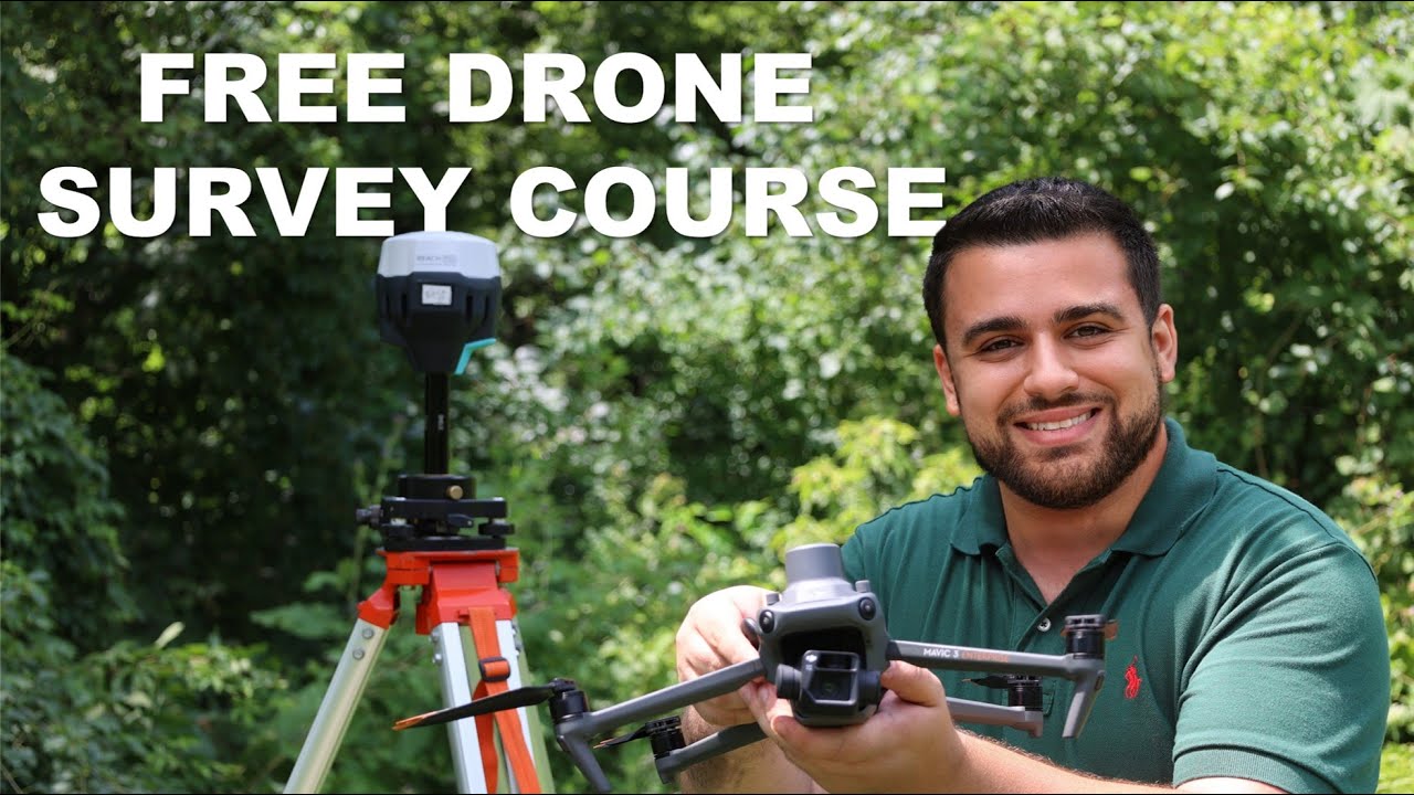
FREE 1 HOUR DRONE SURVEY MASTER COURSERami Tamimi8,987 views | 424 | July 19 2024 19:59:58 (47 comments)[ Read more … ]
📢 WATCH THE REST OF THE 1 HOUR MASTER COURSE HERE – https://thesurveyschool.com/drone-masterclass
Visit The Survey School for resources to elevate your surveying career. Join our school to access courses, premium content, and a supportive community of professionals.
👤 Meet the Surveyor:
Hi there! My name is Rami Tamimi and I am a passionate surveyor and geodetic engineer. With over 10 years of experience in the land development industry, I have a wealth of knowledge to share. That’s why I started my own YouTube channel, educating others about the surveying and geospatial industry and showcasing exciting new technologies. Follow along as I share my expertise and keep up with the latest innovations in my field.
#Surveying #dronesurveying #autocadcivil3d
Advertisement
How Accurate Is Drone Photogrammetry?Jays Tech Vault3,713 views | 120 | July 31 2024 16:00:32 (21 comments)[ Read more … ]
How close are the measurements from drone photogrammetry to real life? How accurate is drone photogrammetry when compared with real and actual measurements? Is drone photogrammetry a reliable way to measure things? What is the best way to measure stuff with drones?
Photogrammetry Software: https://www.aerialmodel.com/
DJI Mini 4, Air 3, and Mavic 3 flight planner: https://www.waypointmap.com/
Revolutionize Your Mapping with Aerial Surveying! #shorts #aerialNexxis Tutorials474 views | 12 | November 8 2024 11:30:27 (0 comments)[ Read more … ]
Discover how aerial surveying is transforming the world of mapping! 🚁✨
From planning flights to capturing high-resolution data, learn how drones and advanced software create accurate maps and 3D models like never before.
Whether you’re a surveyor, engineer, or just curious about the tech, this quick guide shows you the power of aerial surveying in under a minute. 🌍📸
Subscribe for more Land Surveying videos: https://www.youtube.com/channel/UCQqy7_kPrZ0qUd1BcOrNdLA
The Best Precision Mapping & Surveying Drones of 2024 | DSLRProsDSLRPros2,700 views | 0 | August 12 2024 16:00:52 (2 comments)[ Read more … ]
Today we take a look at the best precision mapping and surveying drones of 2024!
Visit https://www.dslrpros.com/ for more information on these incredible drones!
Thanks for watching this video
The Best Precision Mapping & Surveying Drones of 2024 | DSLRPros
📜 About Our Channel 📜
With innovation and technology, our drone experts are continually pushing the limits to provide curated solutions that are rarely found anywhere else. DSLRPros specializes in drone solutions for industrial applications. Whether you’re a first responder or a farmer, we have the right drone for you. We utilize drones to carry thermal cameras for search and rescue and equipment inspection, with a focus on aerial thermal imaging.
Check out our channel here:
https://www.youtube.com/c/Dslrpros/featured
🔔Don’t forget to subscribe🔔
📌CHECK OUT OUR OTHER VIDEOS
➡️Anzu Raptor Drones – First Look! | DSLRPros
🔗https://youtu.be/FM1jsSxuBKg
➡️DJI Dock 2 – First Look! | DSLRPros
🔗https://www.youtube.com/watch?v=xpi0X8JlMcQ
➡️DJI Mavic 3T vs DJI Matrice 30T – DSLRPros Versus
🔗https://youtu.be/Mg_cLkLHwT4
➡️An Introduction to Drone Deploy for Mapping | DSLRPros – Training
🔗https://youtu.be/JGMSzdD_Vzs
➡️Autel EVO Max 4T – First Look | DSLRPros
🔗https://youtu.be/u8wrWOlGWzQ
We sell these awesome products, check them out here:
🔗https://www.dslrpros.com/online-store.html
🔗https://www.dslrpros.com/drones.html
🔗https://www.dslrpros.com/optics.html
🔗https://www.dslrpros.com/accessories.html
🔗https://www.dslrpros.com/software.html
FIND US AT🔍
🔗https://www.dslrpros.com/
FOLLOW US ON SOCIAL
Get updates or reach out to Get updates on our Social Media Profiles!
➡️Facebook
🔗https://www.facebook.com/DSLRPros
➡️Twitter
🔗https://twitter.com/DSLRPros
➡️Instagram
🔗https://www.instagram.com/dslr_pros/
➡️LinkedIn
🔗https://www.linkedin.com/company/dslrpros-com
Important Articles
➡️HOW TO GET FUNDING FOR YOUR DRONE (UAV) PROGRAM! 🔗https://www.dslrpros.com/dslrpros-blog/funding-grant-drone-uav-program-police/
➡️Payloads For Drones In Emergency Response: Guide To What UAVs Carry
🔗https://www.dslrpros.com/dslrpros-blog/payloads-for-drones-in-emergency-response-guide-to-what-uavs-carry/
➡️The Best 12 Drones for Police in 2024: Full Guide, Reviews And Feature Breakdown
🔗https://www.dslrpros.com/dslrpros-blog/best-12-police-drones-in-2024-full-reviews-and-features/
➡️A Glossary of Drone Terminology and Vocabulary
🔗https://www.dslrpros.com/dslrpros-blog/drone-vocabulary-glossary-terminology/
UAV: aerial survey of a GFL recycling plant360 Land Surveying Ltd50 views | 6 | November 26 2024 00:08:52 (0 comments)[ Read more … ]
Fly through a dense point cloud of a GFL recycling plant. This is a survey we completed in 2020 using our DJI Phantom 4 Pro drone. Ground control was set using Leica GS14. It was a very fast and efficient way to produce a site survey, and volume reports for our client.
Advertisement
Drone Outputs | Orthophoto | DTM | DSM | Contour #landsurveying #droneGeotech Spark162 views | 12 | April 12 2024 13:11:21 (1 comments)[ Read more … ]
“Explore the fascinating world of drone surveying with our latest video showcasing Drone Outputs! Learn about Orthophoto, Digital Terrain Models (DTM), Digital Surface Models (DSM), and Contour Mapping, and discover how these outputs are revolutionizing land surveying. Join us on a visual journey through advanced drone technology, capturing precise data for accurate and detailed mapping. Don’t miss this insightful look into the future of surveying! #landsurveying #drone”
Advertisement
About the Author
Patryk Alexander is an associate copy editor at 4kVideoDrones.com, where he sharpens articles and helps keep the website's content clean and error-free. With a background in creative writing, Patryk brings a unique perspective to his editing that helps make 4kVideoDrones.com's content engaging and informative. When he's not editing or writing, Patryk enjoys spending time with his family and exploring the great outdoors.