Unleash the Mapping Power of Your DJI Drone – For FREE!
Ever looked at the crisp, detailed maps and 3D models created by professional drones and thought, "If only I could do that with my DJI Mavic?" Well, get ready to be excited because the drone mapping revolution is here, and the best part? It’s absolutely FREE! Forget expensive software and complicated workflows. We’re diving into the world of free drone mapping solutions that let you transform your trusty DJI Mavic, Air, or Mini into a precision mapping machine. Imagine surveying your property, creating detailed 3D models of your favorite landscapes, or even inspecting roofs with professional-grade accuracy, all without breaking the bank. Sounds too good to be true? Let’s explore the insights from some fantastic YouTube channels that are proving it’s not just possible, it’s easier than you think. Get ready to unlock a whole new dimension of drone capabilities!
Key Insights: Free Drone Mapping is a Reality
Free Software is the Key: The biggest revelation? You don’t need to shell out for pricey, professional mapping software. As Dylan Gorman from Pilot Byte brilliantly demonstrates, free solutions are readily available and incredibly powerful. Think open-source tools and cloud-based platforms that can process your drone imagery into stunning 2D maps and 3D models. It’s a game-changer for hobbyists and even professionals looking for cost-effective options.
Waypoint Mapping for Autonomous Missions: Want your drone to fly a precise mapping mission all on its own? It’s simpler than you think! Waypoint mapping websites, like the one highlighted by JaysTechVault, allow you to plan autonomous flight paths. Upload these missions directly to your DJI Fly app, and watch your drone diligently capture the overlapping images needed for accurate mapping. No more manual flying guesswork – just precise, repeatable data capture.
Photogrammetry Power for Everyone: The magic behind drone mapping is photogrammetry, and it’s no longer a dark art reserved for specialists. As Aerial Model points out, any consumer drone can become a 3D scanner using photogrammetry techniques. By taking overlapping photos from your drone, free processing software can triangulate points and construct detailed 3D models. It’s like turning your drone into a flying 3D camera!
Cloud Processing: No Powerful Computer Required: Worried your laptop isn’t beefy enough for demanding processing? Fear not! MapsMadeEasy, as showcased in Geospatial Tips’ video, offers cloud-based processing. This means the heavy lifting happens on their servers, not yours. Simply upload your drone images, and their platform generates maps, point clouds, and 3D models. It’s accessible drone mapping for everyone, regardless of your computer specs.
DJI Mavic, Air, and Mini Series Compatibility: Good news for DJI owners! Many of these free mapping techniques are directly compatible with popular DJI drones like the Mavic 3 series, Air series, and even the Mini series, including the Mini 4 Pro. You likely already own the hardware needed to start your mapping journey today. Check out the resources linked in the video descriptions for specific drone compatibility details and recommended workflows.
The Democratization of Drone Mapping
What we’re witnessing isn’t just about saving money; it’s a true democratization of drone mapping technology. For years, aerial mapping and 3D modeling were expensive and complex, requiring specialized software and expertise. These videos highlight a paradigm shift. The combination of user-friendly DJI drones and readily available free software is empowering hobbyists, small businesses, and individuals to create professional-quality geospatial data. Imagine the possibilities: land surveys, construction site monitoring, environmental analysis, virtual tourism – all within reach of the average drone enthusiast. This is more than just a trend; it’s a fundamental change in how we interact with and understand our world from above.
Take Flight and Map Your World Today!
The drone mapping revolution is here, it’s free, and it’s waiting for you to join in. These incredible YouTube creators have laid out the tools and techniques; now it’s your turn to take your DJI drone to new heights – literally and figuratively. Start exploring the resources mentioned in these videos, plan your first mapping mission, and prepare to be amazed at what you can create. The sky’s the limit, and the maps are yours for the making!
Keep scrolling to see the videos
Turn Your DJI Drone Into A Mapping Machine For FREE!Dylan Gorman231,968 views | 9,658 | November 8 2024 18:00:27 (587 comments)[ Read more … ]
Discover how to transform your DJI Mavic 3, Air 3, or Mini 4 Pro into a powerful mapping tool without spending a dime on expensive software. This guide unveils the best free drone mapping solutions, allowing you to create professional-grade 2D maps and 3D models.
Become a MASTER at drone mapping with our extensive online course: https://www.pilotbyte.com/drone-mapping-mastery
BEST DRONES TO USE WITH THIS WORKFLOW: DJI Mavic 3 Classic: https://amzn.to/4figwWC DJI Mavic 3 Pro: https://amzn.to/4ff4EEP DJI Air 3: https://amzn.to/3Avugy8 DJI Mini 4 Pro: https://amzn.to/3YGMWmp
Access to sample data: https://bit.ly/4hE9UDo — ► Join us on Pilot Byte! Our platform provides current and aspiring drone operators with information and resources to promote growth and development in the drone industry: https://www.pilotbyte.com
► Subscribe to my channel here: https://www.youtube.com/c/dylangorman — My Camera Equipment! Canon R5: https://amzn.to/36YsAP1 Canon 24-70 2.8L: https://amzn.to/2S2KVCK Rode Microphone: https://amzn.to/3pfokiM Drone: https://amzn.to/3x9GHLW __ Follow me online!
— Chapters 00:00 Intro 01:17 Why Can’t You Use 3rd Party Apps Anymore? 02:22 How To Get Any DJI Drone To Map Autonomously 02:52 Compatible Drones 03:40 Getting Our Drones Ready For Mapping 05:00 Mission Planning 07:40 Mission Upload To DJI FLY App 10:26 Capturing Data Live In The Field Autonomously 13:58 Processing A 2D & 3D Model For FREE 17:06 Master Drone Mapping Online 17:42 Closing
Advertisement
Drone Photogrammetry Processing for FREE!Geospatial Tips172,722 views | 3,197 | March 31 2023 10:49:35 (120 comments)[ Read more … ]
Use your drone to perform drone mapping and photogrammetry, create maps, point clouds and 3D models for FREE with this MapsMadeEasy tutorial! It’s cloud based, so you don’t need a powerful computer either.
Maps Made Easy makes it so simple for anyone who owns a drone or UAV to use photogrammetry and create a map for free and then share it online! But not just DJI drones, their cloud processing app will process any drone images.
See how it compares to commercial offerings such as Agisoft Metashape and Pix4D.
Autel drones are supported as well in their flying app. It’s amazing what they offer free of charge.
Map Pilot Pro (https://dronesmadeeasy.com/map-pilot) supports all of these drones:
Mini 2 Air 2 Air 2S Air Mavic 3 Enterprise (on M3E remote) Mavic 3 Multispectral (on M3M remote) Mavic 2 (Pro, Zoom, and Enterprise – No SMART CONTROLLER support) Mavic 2 Enterprise Advanced Mavic Pro Phantom 4 Phantom 4 Pro * (v2 included) Phantom 4 Advanced Phantom 4 RTK Phantom 3 Professional Phantom 3 Advanced Phantom 3 Standard Inspire 1 Inspire 1 Pro Inspire 2 M30 (on RC Pro Plus remote) M30T(on RC Pro Plus remote) Matrice 100 (M100) Matrice 200 (M200, including V2) Matrice 210 (M210, including V2) Matrice 210 RTK (M210RTK) Matrice 600 (M600) Matrice 600P (M600P) Autel EVOII ( no “V2” support)
*This is not a sponsored video*
How you can support my work ————————————————-
Book a consulting session with me: https://tinyurl.com/4rz33j2d
Support my work on Buy Me a Coffee: https://buymeacoffee.com/geospatialtips
Hire me on Upwork: https://www.upwork.com/freelancers/~016ba4a9bb38699a0e
00:00 – Looking for a Free Alternative? 00:17 – Map Pilot Pro Image Capture 01:20 – Maps Made Easy Data Processing 09:40 – Global Mapper Additional Processing
Turn ANY Drone into a 3D SCANNER And Make 3D Models w/ PhotogrammetryJays Tech Vault32,181 views | 823 | June 4 2024 16:00:49 (51 comments)[ Read more … ]
Turn your drone into a 3d scanner. Create stunning 3d models with any consumer drone. Learn how to make reliable and accurate 3d models and maps with any consumer drone through a process called photogrammetry.
Models from this video: https://www.aerialmodel.com/Home/Viewer?id=241&token=61be705f-0100-4b86-a442-72102fa38c86 https://www.aerialmodel.com/Home/Viewer?id=238&token=a686d651-2ffc-41fc-bcca-fc85bfede566
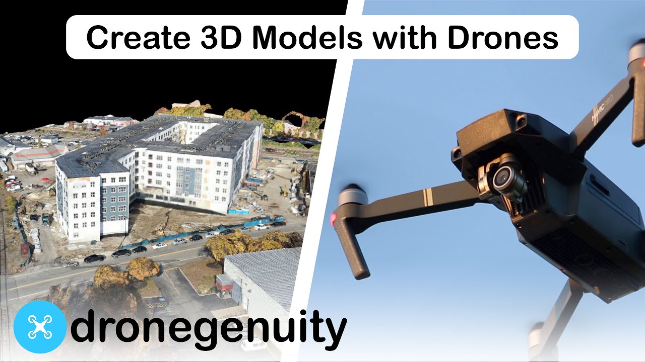
Aerial Photogrammetry Explained – Create 3D Models With Drone Photosdronegenuity246,985 views | 5,724 | January 30 2020 16:00:40 (66 comments)[ Read more … ]
Photogrammetry triangulates points across images to create digital spacial models. Software tools use photogrammetry to turn aerial photos into accurate 3D models. Learn more here – https://www.dronegenuity.com/aerial-photogrammetry/ ⬇︎SHOW MORE⬇︎
About Dronegenuity is a leading nationwide provider of aerial drone photography, video production, and mapping services. We operate across a wide range of industries including real estate & development, construction & engineering, energy, financial services, and work with thousands of skilled pilots in North America.
💡Learn More – https://www.dronegenuity.com/
_________________________________________
🚁Apply to be a Drone Pilot – https://www.dronegenuity.com/pilot-application/
📰Join our newsletter – https://conta.cc/2L7sMjz
_________________________________________
You May Also Like:
How Big Can You Print A Drone Photo? https://youtu.be/FYTlrPJY7Es
How to Take Amazing HDR Drone Photos & Save Time Editing https://youtu.be/4u5FdDeexj0
Point of Interest Tutorial https://youtu.be/ou2iV0u-U2o
What does a drone see from 400, 300, 200, and 100 feet? https://youtu.be/JIfLuTQbCJ8
How to Take Amazing Long Exposure Photos – DJI Drones https://youtu.be/CvE7lAlPZYw
How to Take Great Drone Photos https://youtu.be/54qv-3EPTvE
How to Connect Your Drone to DroneDeploy https://youtu.be/YtGxdAMFFd4
Best Camera Settings – DJI Mavic Pro https://youtu.be/D8EIkoHRi0Q
DroneDeploy Review – Aerial 3D Mapping Software https://youtu.be/i2vJYv0aIcE
Controller Display Screen Overview – DJI Mavic Pro https://youtu.be/W4xC2GCWTgE
17 MUST KNOW Tips & Settings for DJI Mini SE | DansTube.TVDansTube.TV337,654 views | 6,416 | August 23 2021 06:46:40 (565 comments)[ Read more … ]
The Mini SE from DJI is a perfect starter drone but it can be overwhelming for your first few flights, that is why I decided to make a tips and settings video to showcase the 17 MUST KNOW tips and settings for your DJI Mini SE. Sign up to the ultimate online drone course for beginners: https://fearlessdrone.academy/ 🚀 (Use code: “DANSTUBE” to save 10%).
🚀 DRONE DEALS 🚀 Buy DJI Mini SE: https://click.dji.com/AAbCSU_be9-hy90X7-GTRg?pm=link
In this video you will learn all about the flight menu, safety menu, control menu, camera menu, transmission menu and the about menu. I will help you fly safely and confidently, I will also help you get the most out of your new drone. Exclusive DansTube.TV bundles through D1 Store: https://www.d1store.com.au/categories/danstube (contact: sales@d1store.com.au and mention DansTube to unlock special pricing).
Flight Menu (1:42 – 2:28) – Tip #1: Different Modes (2:28 – 3:34) – Tip #2: Pre-Flight Check (3:34 – 4:46) – Tip #3: Map (4:46 – 5:30) – Tip #4: Find My Drone (5:30 – 6:34) – Tip #5: Auto/Pro Mode (6:34 – 7:49) – Tip #6: Battery
Safety Menu (7:49 – 9:14) – Tip #7: Flight Protection (Altitude, Distance and RTH) (9:14 – 10:18) – Tip #8: Sensor Calibration (10:18 – 11:15) – Tip #9: Battery Info
Control Menu (11:15 -12:19) – Tip #10: FPV Mode (12:19 – 14:07) – Tip #11: Advanced Gimbal Settings (14:07 – 14:40) – Tip #12: Flight Tutorial
Camera Menu (14:40 – 15:19) – Tip #13: Histogram (15:19 – 15:40) – Tip #14: Overexposure Warning (15:40 – 16:11) – Tip #15: Gridlines
Transmission Menu (16:11 – 17:31) – Tip #16: Setting Transmission Channels Manually
About Menu (17:31 – 18:13) – Tip #17: Manually Check For Updates
(18:13 – 18:48) – Outro
DansTube.TV offers quality app reviews, hands-on product reviews, exclusive technology/gadgets and awesome weekly content. Dan has made it his mission to help people unlock their creative potential with technology! 📷
Shop fresh new drone merch: http://www.eyeintheskyclothing.com 🚀 ——————————— Subscribe to DansTube.TV: https://www.youtube.com/channel/UCa10m04VDy8yJghT3eJET9Q?sub_confirmation=1 ⭐
Video edited by: https://www.instagram.com/leyoprz ——————————— Connect With Me 👉 https://linktr.ee/danstubetv My YouTube Filming Gear 👉 https://www.amazon.com/shop/danstubetv
Email: hello@danstube.tv Subscribe, Like and Comment. ——————————— Amazon & DJI affiliate disclosure: I do receive a small amount of commission if you purchase a product using my Amazon or DJI links. Purchasing through my links adds NO additional cost to your purchase. ———————————
Advertisement
How to INSTALL ATAK and the UAS PLUGIN in the DJI Mavic 3TSKYNET DRONE SYSTEMS9,401 views | 216 | May 20 2024 16:00:04 (86 comments)[ Read more … ]
A tutorial on how to install ATAK, TAK, the UAS Plugin, ATAKGoV5, and ATAKGo.
Payload Drop Video https://youtu.be/GS5vVm9BWy0?si=SZs4pzrQG6isoQ7u
TAK registration and download https://tak.gov
Tak Syndicate Reddit page https://www.reddit.com/r/ATAK/wiki/index
ATAK/TAK is the core of a suite of georeferenced imagery and communications tools that allow for scaled operational planning, data sharing, visualized elevation data, and target management. With TAK, your team can get oriented quickly, make better informed decisions and quickly respond to threats. Add TAK to your operations, and make sure when your team deploys, you have the unfair advantage.
Advertisement
About the Author
Patryk Alexander is an associate copy editor at 4kVideoDrones.com, where he sharpens articles and helps keep the website's content clean and error-free. With a background in creative writing, Patryk brings a unique perspective to his editing that helps make 4kVideoDrones.com's content engaging and informative. When he's not editing or writing, Patryk enjoys spending time with his family and exploring the great outdoors.