Waypointmap Drone Software: Revolutionizing 3D Mapping 🚀
Senior Associate Copy Editor
Elevating drone mapping! Waypointmap simplifies complex missions, democratizes automated 3D mapping, and turns any drone into a 3D scanner. Learn how!
Elevating Drone Mapping with Waypointmap: Insights from Leading YouTube Channels
The evolution of drone technology has fundamentally reshaped industries reliant on spatial data, and at the forefront of this transformation is 3D mapping. Pilots, surveyors, and even hobbyists are now capable of creating highly detailed 3D models and maps with unprecedented ease and precision. What’s driving this revolution? Much of it comes down to intelligent software solutions that streamline mission planning and execution. Waypointmap Drone Software is rapidly emerging as a pivotal tool in this space, simplifying complex workflows and unlocking advanced capabilities for a wider range of drone operators. The buzz around Waypointmap is evident across the drone community, and YouTube is proving to be a rich source of insights into its practical applications. Let’s dive into key takeaways from popular drone channels, revealing how Waypointmap is changing the game.
Key Insights Unveiled: Waypointmap in Action on YouTube
Simplified Complex Missions: As demonstrated in "How to Load Custom Waypoint KMZ Files on DJI RC 2 | Create Complex Waypoint Missions Easily!", Waypointmap drastically simplifies the creation of intricate waypoint missions. Instead of wrestling with cumbersome in-app controls on the RC 2, pilots can pre-plan complex routes on a computer using tools like waypointmap.com, Google Earth, and even leverage existing KMZ files. This offloading of mission planning to more powerful interfaces translates to increased efficiency and precision in the field. Think about setting up intricate inspection patterns around cell towers or designing detailed survey grids for construction sites – Waypointmap streamlines it all.
Democratizing Automated Mapping: The video "Mission Planning Tutorial for DJI Mavic 3 Pro, Mini 4 Pro, and Air 3 for Photogrammetry / 3D mapping" highlights a critical advantage: Waypointmap enables automated mapping even on drones lacking SDK support. This is a game-changer for pilots using popular models like the DJI Mini 4 Pro, Mavic 3 series, and Air 3. Photogrammetry, once perceived as a complex and technically demanding process, is now accessible to a broader audience. The ability to automate flight paths for data capture ensures consistent image overlap and optimal angles – crucial for generating accurate 3D models.
Transforming Any Drone into a 3D Scanner: "Turn ANY Drone into a 3D SCANNER And Make 3D Models w/ Photogrammetry" emphasizes Waypointmap’s versatility. By focusing on mission planning through waypoint automation, Waypointmap essentially turns any compatible drone into a tool capable of collecting data for high-quality 3D models. The examples showcased, with links to aerialmodel.com, vividly illustrate the tangible results – from detailed scans of structures to comprehensive environmental models. This accessibility broadens the application of 3D mapping to professionals and enthusiasts alike.
Massive Mapping Capabilities Unlocked: "How to Take MASSIVE Pictures (Maps) with ANY Drone" points to Waypointmap’s power in capturing large-scale datasets. For projects requiring expansive coverage, such as agricultural surveys, infrastructure monitoring across vast areas, or even large real estate developments, Waypointmap allows pilots to efficiently plan and execute missions that capture the necessary imagery. The mention of creating maps and "huge images of huge areas" underscores the scalability enabled by precise waypoint-based flight planning.
Beginner-Friendly Photogrammetry: "3d mapping for beginners – how to do Photogrammetry with Mavic 3 pro" explicitly targets newcomers to 3D mapping, emphasizing Waypointmap’s ease of use. The video promises that beginners can be "up and running in 5 minutes," highlighting the intuitive nature of the platform. By linking Waypointmap to resources like Maps Made Easy for processing and TFR/weather apps for safe operations (Aloft, Dronecast, FAA TFR site), it presents a complete and accessible workflow for those just starting with drone-based 3D mapping. This user-friendliness is key to wider adoption of the technology.
Practical Application in Agriculture and Beyond: "Mapping Sample using the DJI Air 3, Waypoint Map and WebODM" offers a real-world example of Waypointmap in action for a practical application – agriculture. The farmer’s use case of acreage estimation highlights the tangible benefits of drone mapping in operational contexts. The video emphasizes the reliability and ease of use of Waypointmap during a live mission, processing data with WebODM. This demonstration strengthens the credibility of Waypointmap as a robust tool for professional applications.
Precision in the Air, Clarity on the Ground
What these videos collectively showcase is that Waypointmap isn’t just another flight planning app; it’s a catalyst for broader adoption and innovation in drone-based 3D mapping. By simplifying mission complexity, extending capabilities to popular drone models, and streamlining the entire workflow, Waypointmap empowers pilots to achieve higher quality results more efficiently and safely. The emphasis on ease of use and accessibility democratizes advanced mapping techniques, putting powerful tools into the hands of a wider community of drone operators.
How to Load Custom Waypoint KMZ Files on DJI RC 2 | Create Complex Waypoint Missions Easily!All Streamed Up16,868 views | 470 | August 4 2024 17:47:40 (95 comments)[ Read more … ]
Welcome to my latest tutorial where I reveal how to load custom waypoint KMZ files onto your DJI RC 2! 🚁✨ Whether you’re a seasoned pilot or just starting out, this video will show you how to easily and quickly create more complex waypoint missions on your computer, without needing to take off your drone.
Download the KMZ installer here: https://drive.google.com/drive/folders/14I8v9K_hXEyKhT5Lx4GYepEsX4u91KrR
In this video you will learn: – How to use waypointmap.com for creating precise waypoints – Utilizing airdata.com for mission analysis and optimization – Leveraging the power of Google Earth for advanced mapping – Seamlessly integrating with Mac OS X, Parallels Desktop, and Windows 10 to streamline your workflow
Tools and Software Covered:
– waypointmap.com: Your go-to for creating and editing waypoints – airdata.com: Analyze and optimize your missions like a pro – Google Earth: The ultimate tool for detailed mapping – Mac OS X and Parallels Desktop: Run Windows 10 on your Mac to access all necessary software – Windows 10: For all the drone software needs that require a Windows environment
Don’t forget to like, subscribe, and hit the bell icon so you never miss an update on the latest drone tips and tutorials! ✈️🔔
Watch Now and Take Your Drone Missions to the Next Level!
Mission Planning Tutorial for DJI Mavic 3 Pro, Mini 4 Pro, and Air 3 for Photogrammetry / 3D mappingJays Tech Vault52,503 views | 949 | February 18 2024 17:40:12 (228 comments)[ Read more … ]
Want to do mission planning on your DJI Mavic 3 Pro, Mini 4 Pro, and Air 3 for free? Want to do automated mapping in order to generate 3d maps and photogrammetry models? Photogrammetry and 3d mapping is an essential part of a part 107 drone pilots toolset.
I made a free tool called https://www.waypointmap.com/ It lets you do mission planning, automate mapping, on drones with no sdk support. WaypointMap is a great tool to generate your flight plans.
0:00 Intro 0:25 How to plan a mission 7:45 Setup Intro 8:22 DJI RC-N1/RC-N2 Setup 9:22 DJI RC 2 Setup 10:10 DJI RC Setup 11:17 How to check everything is working 11:35 Things to know 12:25 How to start a mission
Turn ANY Drone into a 3D SCANNER And Make 3D Models w/ PhotogrammetryJays Tech Vault31,615 views | 809 | June 4 2024 16:00:49 (51 comments)[ Read more … ]
Turn your drone into a 3d scanner. Create stunning 3d models with any consumer drone. Learn how to make reliable and accurate 3d models and maps with any consumer drone through a process called photogrammetry.
Models from this video: https://www.aerialmodel.com/Home/Viewer?id=241&token=61be705f-0100-4b86-a442-72102fa38c86 https://www.aerialmodel.com/Home/Viewer?id=238&token=a686d651-2ffc-41fc-bcca-fc85bfede566
How to Take MASSIVE Pictures (Maps) with ANY DroneJays Tech Vault6,163 views | 171 | June 19 2024 16:11:30 (22 comments)[ Read more … ]
Want to make maps with your drone? Want to take pictures from higher up than legally possible? Want to capture huge images of huge areas? In this video I show you how to make maps with your drone.
Model/Map from this video: https://www.aerialmodel.com/Home/Viewer?id=2527&token=226400fd-1e8c-480f-8dd6-38246358c98e
3d mapping for beginners – how to do Photogrammetry with Mavic 3 proHow to by Lou – tips + Everything that Glitches550 views | 15 | December 22 2024 04:58:58 (10 comments)[ Read more … ]
Free Online Waypoint Tool For Photogrammetry and 3D Mapping with DJI Mini 4 Pro
@DJI @DJISupportGlobal
how to do Photogrammetry for beginners, it’s so easy you will be up and running in 5 minutes.
3d Map of Soccer Field https://www.mapsmadeeasy.com/maps/public_3D/771bc1dea03f4625a2ac378bdc23f0f5/
Sample 1 of Corner https://www.mapsmadeeasy.com/maps/public_3D/98e891805a7042738fe05a654b821dda/
Other Supported drones for 3d mapping DJI Mavic 3 Pro/Mavic 3/Mavic 3 Classic
you can do 3d mapping with the DJI Air 3/3s
Fly automated missions on the DJI Mini 4 Pro, Air 3/3S, or Mavic 3/3P/3C
Photogrammetry for beginners https://www.waypointmap.com
Maps Made Easy – upload your images here https://www.mapsmadeeasy.com/
Useful Apps Check for TFRs https://www.aloft.ai/air-control/
FAA Directly check for TFRs https://tfr.faa.gov/tfr2/list.html
Check wind to make sure weather is optimal for your flight https://dronecast.app/
Check again for TFRs Airaware Apple https://apps.apple.com/us/app/aloft-air-aware/id6471439866
Check again for TFRs Airaware Android https://play.google.com/store/apps/details?id=ai.aloft.airaware&hl=en_US
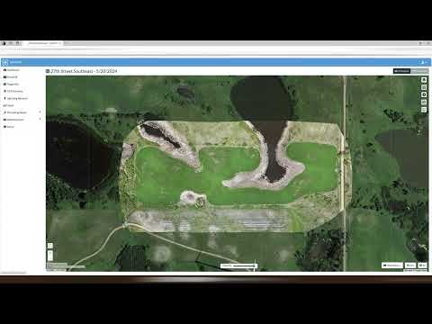
Mapping Sample using the DJI Air 3, Waypoint Map and WebODMDK4Drones1,057 views | 18 | July 13 2024 21:16:35 (6 comments)[ Read more … ]
This I did a while back as a practice run using Waypoint Map to fly the mission for a friend who is a farmer. It seemed to work great, and I had on issue with Waypoint Map at all. This was at 395 ft (high because we are trying to see roughly how many acres were planted) and -90 gimbal angle and 80% overlap using the Air 3 with Waypoint Map to fly the mission and WebODM to process the data.
About the Author
Patryk Alexander is an associate copy editor at 4kVideoDrones.com, where he sharpens articles and helps keep the website's content clean and error-free. With a background in creative writing, Patryk brings a unique perspective to his editing that helps make 4kVideoDrones.com's content engaging and informative. When he's not editing or writing, Patryk enjoys spending time with his family and exploring the great outdoors.