Alright folks, gather ’round! Ever looked at a construction site before the first shovel hits the dirt? Just a patch of land, right? Maybe some stakes, some flags. But what if you could peel back the layers, see the terrain like a hawk, and plan every move with crystal clarity before the heavy machinery even arrives? That’s the magic we’re talking about, and it’s all thanks to drone mapping. Here at the store, we see this revolution firsthand, and let me tell you, it’s changing the game. I’ve been digging through some fantastic YouTube content lately, and it’s got me even more fired up about what these flying marvels can do for pre-construction. Ready to see what I found? Let’s dive in!
Soaring to New Heights in Pre-Con: Key Insights from the Web
These aren’t just pretty aerial shots, folks. We’re talking about actionable intelligence, the kind that saves time, money, and headaches. Here’s what the buzz online is all about:
Unveiling the Orthomosaic Advantage: Ever heard of an orthomosaic map? Think of it as a super-accurate, geographically corrected aerial photo. The folks over at The Drone Life in their “Drone Mapping for Construction: Complete Guide” video (Video 1) nail it. They show how these detailed maps, stitched together from hundreds of drone images, provide a crystal-clear picture of the site. Imagine seeing every contour, every existing feature with pinpoint accuracy. Forget those blurry satellite images! This is like having the site laid out on your screen in incredible detail, letting you plan everything from access roads to material laydown areas with confidence. You can practically feel the texture of the terrain just by looking at it.
Real-Time Progress, Real-World Savings: Sticking with The Drone Life, their “Drone Construction Progress Monitoring: Flight Demonstration” (Video 2) really hits home. They walk you through a live flight, showcasing how drones capture site data. Think about the traditional way: surveyors with their equipment, days of work. Now? A drone can capture the same data in a fraction of the time. You get a visual record, a snapshot in time, that allows you to track progress meticulously. See the earth being moved, materials arriving – it’s all there, documented from above. This isn’t just about pretty pictures; it’s about staying on schedule and on budget. I can almost hear the project managers breathing easier already!
Skender’s Vision: Drones as Pre-Con Power Tools: The video “How Skender Uses Drones in Precon | Reality Capture for Construction | Aerial Mapping” (Video 3) from DroneDeploy gives us a peek into how a major player leverages drone tech. They talk about integrating drone data with logistics planning, improving communication across teams, and creating a rich jobsite context. Imagine project managers, architects, and engineers all looking at the same, highly detailed 3D model of the site. No more conflicting interpretations of blueprints! They even highlight how this tech differentiates them from competitors. That’s a key takeaway for any forward-thinking construction firm – this isn’t just a trend, it’s a competitive edge. You can practically see the improved collaboration happening on screen.
Witnessing the Transformation Week by Week: The “Southern Post Mixed-Use Development – Week 21 Drone Construction Progress Monitoring 09/29/2022” video (Video 4) provides a tangible example. While focused on progress monitoring, the principle applies directly to pre-con. Imagine having this level of visual detail before breaking ground. Understanding the existing site conditions, identifying potential challenges – it’s invaluable. You get a sense of the scale of the project, the lay of the land, all captured with the smooth, gliding motion of the drone.
Building the Future, One Pixel at a Time in Kentucky: The aptly titled “Building Kentucky’s Future with 3D Aerial Mapping 🚧🔍” (Video 5) emphasizes the power of 3D. It’s not just about flat maps anymore. We’re talking about creating interactive, digital replicas of the site. Think about the insights this provides for site management and material estimation. You can practically walk through the site virtually, before a single foundation is poured.
Global Perspectives: Elevating Pre-Con Excellence in India: Even across the globe, the message is clear. The “@indiadroneacademy “Elevating Pre-Construction Excellence: Drone-Driven Site Review & Planning”” webinar announcement (Video 6) highlights the international embrace of this technology. They emphasize accuracy and efficiency in site surveying – core benefits that resonate regardless of location. You can almost hear the enthusiasm in the description for professionals looking to advance their skills.
The Future is in the Air: Smarter Planning, Smoother Builds
Looking at these videos, a clear picture emerges. Drone mapping isn’t just a fancy gadget; it’s a fundamental shift in how we approach pre-construction. We’re moving beyond guesswork and embracing data-driven decisions. Think about the possibilities:
Enhanced Collaboration: Imagine project teams, investors, and even potential buyers all viewing the same accurate, up-to-date visual representation of the site. Miscommunication becomes a thing of the past.
Early Issue Detection: Identifying potential problems – like unexpected terrain features or drainage issues – before construction begins saves significant time and money. It’s like having a detailed X-ray of your site.
Optimized Logistics: Planning material storage, equipment access, and site layout becomes incredibly efficient with precise aerial data. You can visualize the entire operation before it even starts.
Accurate Volumetric Measurements: Need to know how much earth needs to be moved? Drones can provide highly accurate volume calculations, crucial for budgeting and planning.
Ready to Take Your Pre-Con to the Next Level?
The evidence is clear: drone mapping is no longer a novelty; it’s a necessity for efficient and successful pre-construction planning. These videos offer just a glimpse into the power and potential. Here at [Your Drone Hobbyist Store Name], we’re passionate about helping you harness this technology. Whether you’re a seasoned construction professional or just starting to explore the possibilities, we’ve got the drones, the software, and the expertise to get you off the ground.
Scroll down to watch the video highlights and see for yourself the revolution in action! And don’t hesitate to swing by the store or give us a call. We’re always excited to talk drones and help you find the perfect solution for your needs. Let’s build smarter, together!
See the hand-picked videos below
Drone Mapping for Construction: Complete GuideThe Drone Life322,464 views | 9,053 | November 17 2021 22:43:05 (170 comments)[ Read more … ]
Claim Your FREE GUIDEBOOK to Using Drones in Construction 👇 https://bit.ly/42MY2b9
In this video, you will learn what are orthomosaic drone maps, the benefits of drone mapping in construction, and how to map a construction site using a drone.
So if you are a construction company looking to get started in drone mapping or if you’re a pilot looking to expand your service offerings, this video is for you.
We’ve been producing 2D orthomosaic maps at this 500,000 Sq Ft warehouse job site. These maps are greatly beneficial for improving communication, planning construction phases, keeping records, monitoring progress, and sharing with project stakeholders.
Using a Mavic 2 Pro drone and mapping software Dronedeploy, we’re going to share our mapping workflows, best practices, and tips!
►Resources ➡️ Start Your FREE 14-Day DroneDeploy Trial Now – http://bit.ly/3EPADdN
►Our Must-Have Drone Equipment Checklist ✅ Budget Friendly Ground Control Points (GCPs) – http://bit.ly/3nAT2pH ✅ Most Reliable SD Card for Drone Mapping – http://bit.ly/3lZOhWn ✅ Heavy Duty Landing Pad – http://bit.ly/3zt1hXA ✅ Collapsable Orange Safety Cones – http://bit.ly/40Tr2fp ✅ OSHA Certified Safety Vest -http://bit.ly/3KsycSt ✅ Wind Speed Anemometer Gauge – http://bit.ly/3ZCaYO5 ✅ Best Flight Planning Tablet – http://bit.ly/40Dci4q ✅ Handheld VHF Airband Transceiver – http://bit.ly/40AyLPP
►About The Drone Life The Drone Life is an industry-leading UAS service provider that provides turnkey aerial data solutions nationwide. We proudly specialize in the industrial, environmental, renewable, and construction industries. Our team consists of highly experienced, dependable, and licensed drone professionals that are committed to safety, quality, and customer success.
►Chapters 0:00 Intro 0:34 What are orthomosaic drone maps? 1:21 Benefits of drone mapping 3:58 Flight planning 14:28 Flying the site 18:49 Conclusion
#dronemapping #dronesinconstruction #construction
Advertisement
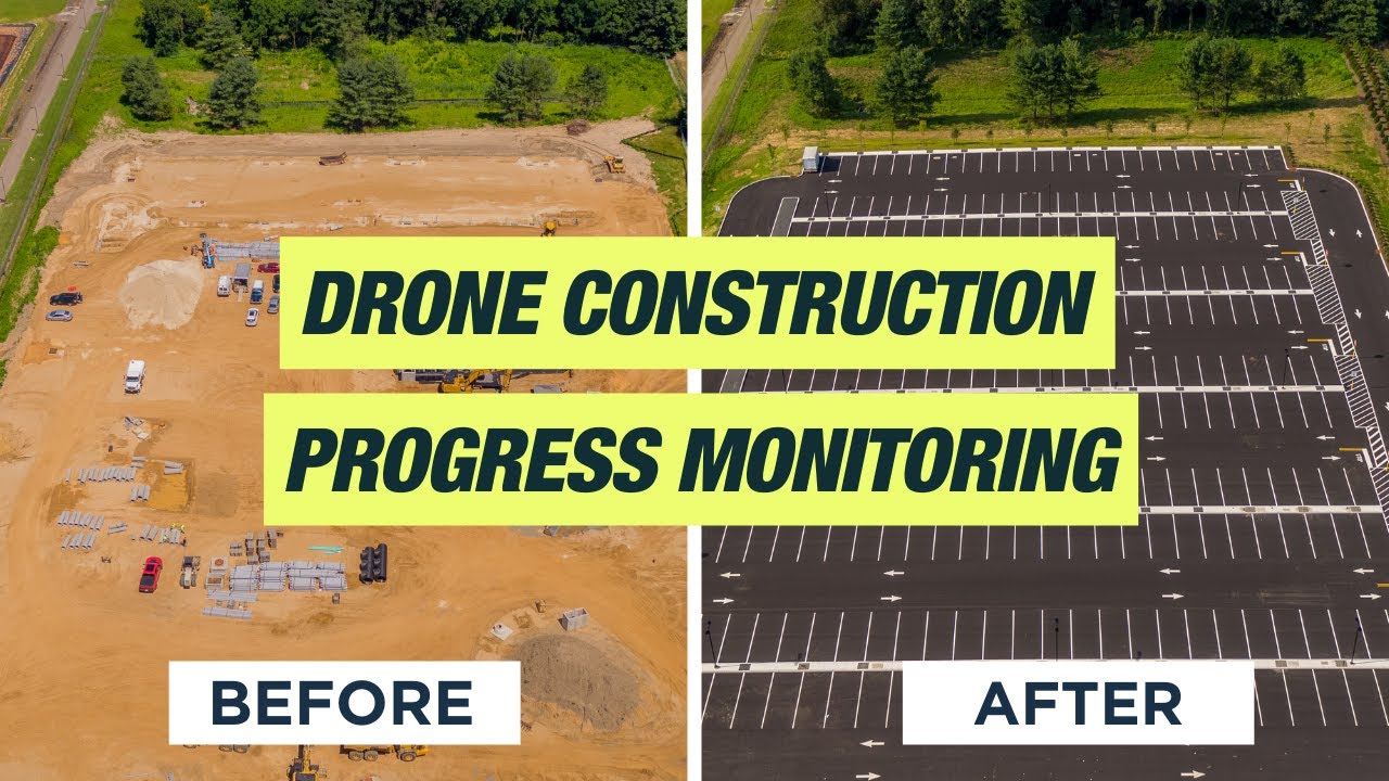
Drone Construction Progress Monitoring: Flight DemonstrationThe Drone Life23,570 views | 690 | October 5 2021 18:08:27 (35 comments)[ Read more … ]
Claim Your FREE GUIDEBOOK to Using Drones in Construction 👇 https://bit.ly/42MY2b9
In this video, we will walk you through how The Drone Life monitors the progress of an active construction site starting with a flight demonstration. As we move step by step through the project and we will show you how we monitor changes, we will talk about the benefits to using drones to collect project data, how we document the construction progress, and give you several case studies to use for your own projects.
Using drones for construction progress monitoring is important to ensure the work is moving at the level specified in the building contract. Data collected by drone flights look at establishing the level of completion, identifying and reporting potential changes, locating the status of stored materials, and to ensure the agreed upon construction schedule is being maintained. Once the data is collected and processed a report is created to determine if the site follows the client’s scope of work.
To help you learn how these flights are completed we will go through a narrated flight demonstration and show what data can be collected and for what purposes. You should take into consideration the data you need to collect such as progress monitoring, stockpile measurements, earthwork surveys, 3D maps, pre-construction planning, LIDAR, material reporting and logistics, and orthomosaic maps. Collect only the data you need to save time and money and decide on the frequency you need the data collected, monthly, biweekly, or weekly. In addition to progress monitoring, once the data is collected it can be used to keep stakeholders informed, for marketing the properties, and documentation records for future use.
#drone #dronefootage #dronesinconstruction
►Resources Drones in Construction Ultimate Guide PDF – https://bit.ly/3l8lueR
Drone Construction Progression Monitoring Article – https://bit.ly/3l8lueR
Case Study – https://thedronelifenj.com/projects/
►Equipment Used in this Video Mavic 2 Pro Drone – https://amzn.to/3C62yom
►Our Must-Have Drone Equipment Checklist ✅ Budget Friendly Ground Control Points (GCPs) – http://bit.ly/3nAT2pH ✅ Most Reliable SD Card for Drone Mapping – http://bit.ly/3lZOhWn ✅ Heavy Duty Landing Pad – http://bit.ly/3zt1hXA ✅ Collapsable Orange Safety Cones – http://bit.ly/40Tr2fp ✅ OSHA Certified Safety Vest -http://bit.ly/3KsycSt ✅ Wind Speed Anemometer Gauge – http://bit.ly/3ZCaYO5 ✅ Best Flight Planning Tablet – http://bit.ly/40Dci4q ✅ Handheld VHF Airband Transceiver – http://bit.ly/40AyLPP
►About The Drone Life The Drone Life is an industry-leading UAS service provider that provides turnkey aerial data solutions nationwide. We proudly specialize in the industrial, environmental, renewable, and construction industries. Our team consists of highly experienced, dependable, and licensed drone professionals that are committed to safety, quality, and customer success.
►Chapters 0:00 Introduction 0:28 Topics Outline 1:32 Photo Documentation 3:38 Case Studies 4:59 Flying the Site 7:42 Marketing Drone Footage 9:03 Considerations 9:50 FAA Permissions 10:42 Outro
Advertisement
How Skender Uses Drones in Precon | Reality Capture for Construction | Aerial MappingDroneDeploy594 views | 11 | January 10 2023 21:04:31 (2 comments)[ Read more … ]
In this video, discover how premier construction company, Skender, uses drones and reality capture technology to gain full clarity in the pre-construction phase of a project.
Timestamps: 00:00 – Intro 01:10 – Integrating DroneDeploy with logistics planners 02:01 – How drone flights helps cross-team communication 02:44 – How drones help create jobsite context 04:05 – How Skender differentiates from competitors in pre-construction 05:25 – How Skender leverages 3D models 06:59 – How DroneDeploy visuals help communicate to Skender teams 08:01 – How long it takes to build 3D models 09:20 – Outro
=========== Get a demo: http://bit.ly/3jTmNQK =========== FOLLOW DRONEDEPLOY Instagram: https://www.instagram.com/dronedeploy/ LinkedIn: https://www.linkedin.com/company/dron… Twitter: https://www.twitter.com/DroneDeploy Facebook: https://www.facebook.com/Dronedeploy Website: https://www.dronedeploy.com
Southern Post Mixed-Use Development – Week 21 Drone Construction Progress Monitoring 09/29/2022Brian Macdonald77 views | 3 | March 11 2023 18:14:57 (1 comments)[ Read more … ]
Week 21 in the ongoing Southern Post series follows the construction of a new Southern Post Mixed-Use Development in Roswell, Georgia. This is a drone construction monitoring video day of September 29, 2022, condensing the week of September 25 – October 01, 2022.
Using drones for construction progression monitoring is essential to ensure the work is moving at the level specified in the building contract. Data collected by drone flights look at establishing the level of completion, identifying and reporting potential changes, the status of stored materials, and ensuring the agreed-upon construction schedule is on schedule.
Project Managers, Superintendents, and investors should consider the data you’ll need to collect drone video progress monitoring, stockpile measurements, earthwork elevations, orthomosaic 2D maps, 3D maps, pre-construction planning, material reporting, and logistics. Collect only the data you need to save time and money. Decide the frequency you need the data collected, monthly, biweekly, or weekly. In addition to progress monitoring, once the data is collected, you can use it to keep stakeholders informed, for marketing the properties, and for documentation records for future use.
Advertisement
Building Kentucky’s Future with 3D Aerial Mapping 🚧🔍Aerial Photography Louisville69 views | 0 | October 31 2024 16:25:55 (0 comments)[ Read more … ]
Our 3D aerial mapping technology is revolutionizing the construction industry right here in Kentucky! 🛠️🚁 From pre-construction planning to progress tracking, our high-precision mapping captures every detail of the landscape, helping projects run smoother and more efficiently. See how our aerial solutions provide invaluable insights for site management, material estimates, and more. #ConstructionMapping #3DAerialMapping #KentuckyConstruction #DroneMapping #SitePlanning
Advertisement
@indiadroneacademy “Elevating Pre-Construction Excellence: Drone-Driven Site Review & Planning”India Drone Academy24 views | 0 | July 2 2024 05:38:35 (0 comments)[ Read more … ]
@indiadroneacademyWelcome to the India Drone Academy’s exclusive webinar on Pre-Construction Site Review and Planning with Drones! Join us for an insightful exploration into leveraging drone technology to revolutionize the pre-construction phase.
In this webinar, you’ll gain invaluable insights into: – How drones enhance site surveying accuracy and efficiency before construction begins. – The transformative impact of drone data in detailed site mapping and analysis. – Case studies showcasing successful integration of drones in pre-construction planning. – Practical tips on adopting drone technology for site review and planning processes. – Guidance on becoming a certified drone pilot and advancing your career in construction planning.
Whether you’re a construction professional, architect, or drone enthusiast, this webinar offers essential knowledge to optimize pre-construction strategies with cutting-edge drone technology.
Don’t miss out on this opportunity to stay ahead in the industry. Register now and join us as we explore the future of pre-construction site review with drones!
FOR MORE INFORMATION :- Email – https://www.indiadroneacademy.com/
Patryk Alexander is an associate copy editor at 4kVideoDrones.com, where he sharpens articles and helps keep the website's content clean and error-free. With a background in creative writing, Patryk brings a unique perspective to his editing that helps make 4kVideoDrones.com's content engaging and informative. When he's not editing or writing, Patryk enjoys spending time with his family and exploring the great outdoors.