Drone Photogrammetry: Revolutionizing Mapping & Surveying 🌎🚀 – Your Window to the 3D World
Ever gazed down at the landscape from above, whether a sprawling cityscape or a rugged coastline, and wished you could capture that perspective in intricate detail? As drone enthusiasts, we know the thrill of seeing the world from a new vantage point. But what if I told you that your trusty drone is capable of so much more than just stunning photos and videos? Welcome to the fascinating world of drone photogrammetry, a game-changer that’s rapidly transforming how we map and survey our planet.
Imagine turning your aerial images into precise, measurable 3D models and maps. No longer relegated to expensive specialized equipment, this powerful technique is becoming increasingly accessible to hobbyists like us. Curious how? We’ve scoured YouTube for the most insightful videos to bring you the essential knowledge. From unlocking free mapping capabilities on your DJI drone to witnessing the creation of breathtaking 3D models of volcanoes, these videos offer a glimpse into the exciting possibilities. Ready to see how drones are revolutionizing mapping and surveying, one pixel at a time? Let’s dive in!
Key Takeaways: Unlocking the Power of Drone Photogrammetry
Here’s a breakdown of the essential insights gleaned from our YouTube explorations, equipping you with the knowledge to take your drone’s capabilities to the next level:
Free Mapping Magic with DJI: Forget shelling out for pricey software! Video #1, "Turn Your DJI Drone Into A Mapping Machine For FREE!", reveals how you can leverage existing tools and free platforms like Waypoint Map and Reality Capture to transform your DJI Mavic 3, Air 3, or Mini 4 Pro into a potent mapping tool. Imagine autonomously flying pre-planned missions and then processing the data to create professional-grade 2D maps and even stunning 3D models – all without breaking the bank. The feeling of accomplishment when those data points coalesce into a tangible representation of the landscape is truly something special.
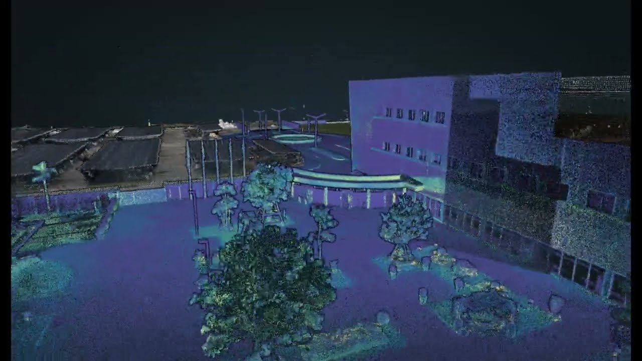
The DJI Air 3S: A Photogrammetry Powerhouse? Video #2, "DJI Air 3S For Photogrammetry and 3D Modeling Review," puts DJI’s latest offering through its paces for commercial-grade photogrammetry. This isn’t just about pretty pictures; it’s about precision and accuracy. The video explores the quality of the 3D models and maps generated by the Air 3S, addressing the critical question: can this drone be a serious tool for professional applications? Seeing the sample 3D models of a baseball field and picnic area, linked in the video description, truly brings the Air 3S’s capabilities into sharp focus. You can practically feel the texture of the grass and the curve of the baseball diamond.
Democratizing 3D Mapping: Echoing the theme of accessibility, Video #3, "FREE 3D Drone Mapping Software – DJI Air 3s – DJI Mini 4 Pro," further emphasizes that powerful 3D mapping isn’t locked behind expensive paywalls. It showcases practical workflows using platforms like Waypoint Map for mission planning and Aerial Model for processing, specifically targeting users of the DJI Mini 4 Pro and Air 3/3s. This reinforces the idea that cutting-edge technology is increasingly within reach for enthusiasts like us.
From Sky to Screen: Witnessing a Volcano in 3D: Video #4, "3D model of Sakurajima’s lava vent #photogrammetry #volcano #sakurajima #桜島," provides a breathtaking example of photogrammetry in action. The creator captures the raw power and unique geological features of a volcano’s lava vent and transforms drone footage into a tangible, explorable 3D model using Reality Capture. This isn’t just mapping; it’s digital preservation, allowing us to study and appreciate these dynamic environments in incredible detail. Imagine the roar of the volcano, the smell of sulfur, translated into a digital twin.
Photogrammetry in a Nutshell: For those looking for a quick but comprehensive overview, Video #5, "Photogrammetry and Drone Surveying: Everything You Need in 3 Minutes," offers a concise introduction to the core concepts. While leaning towards surveying applications with tools like RTK (Real-Time Kinematic) receivers, it effectively distills the essence of photogrammetry and its value in data collection. Think of it as a rapid-fire briefing on the power of aerial data acquisition.
Drones Revolutionizing Industries: Mapping Mines with Wingtra: Stepping into the realm of professional applications, Video #6, "Wingtra: Mapping Mines with Advanced Automated Drones #267," highlights how high-end fixed-wing drones like those from Wingtra are transforming industries like mining. Featuring interviews with experts, the video showcases the efficiency and accuracy of using drones with advanced sensors like LiDAR alongside traditional photogrammetry for creating detailed digital twins of mining sites. This demonstrates the scalability and impact of drone photogrammetry in demanding industrial environments – imagine the vastness of the mine site, captured with pinpoint accuracy.
Peering into the Pixels: Emerging Trends and the Future of Drone Photogrammetry
Analyzing these videos, a clear trend emerges: drone photogrammetry is becoming increasingly accessible and powerful. The democratization of software, coupled with the advancements in consumer-grade drone cameras, is putting sophisticated mapping capabilities into the hands of more enthusiasts and professionals alike. We’re seeing a shift from purely visual applications to data-driven insights, allowing for precise measurements, volume calculations, and detailed environmental analysis.
The integration of technologies like RTK and PPK (Post-Processed Kinematic) – which enhance positional accuracy – is becoming more common, even trickling down into some higher-end consumer drones. This means the data we collect is becoming even more reliable for surveying and mapping applications.
Looking ahead, we can expect to see further advancements in automated flight planning and data processing. Artificial intelligence and machine learning will likely play a larger role in streamlining workflows, making it even easier to extract meaningful information from our aerial imagery. Imagine software that automatically identifies and measures objects within your 3D models! The possibilities are truly exciting.
Your Next Flight Awaits: Explore the World from a New Dimension
These YouTube gems offer just a glimpse into the transformative power of drone photogrammetry. Whether you’re a seasoned pilot or just getting started, the tools and knowledge are increasingly available to turn your aerial passion into tangible 3D realities. The ability to capture and recreate our world in such intricate detail is not just a technical feat; it’s a way to deepen our understanding of the spaces we inhabit.
Ready to take your drone skills to the next level? Scroll down and immerse yourself in the videos themselves. Witness the processes, the results, and the sheer ingenuity of fellow drone enthusiasts and industry professionals who are pushing the boundaries of what’s possible. The sky is no longer the limit – it’s just the starting point for creating your own digital landscapes.
Keep reading for the highlighted videos
Turn Your DJI Drone Into A Mapping Machine For FREE!Dylan Gorman208,897 views | 8,799 | November 8 2024 18:00:27 (561 comments)[ Read more … ]
Discover how to transform your DJI Mavic 3, Air 3, or Mini 4 Pro into a powerful mapping tool without spending a dime on expensive software. This guide unveils the best free drone mapping solutions, allowing you to create professional-grade 2D maps and 3D models.
Become a MASTER at drone mapping with our extensive online course: https://www.pilotbyte.com/drone-mapping-mastery
BEST DRONES TO USE WITH THIS WORKFLOW: DJI Mavic 3 Classic: https://amzn.to/4figwWC DJI Mavic 3 Pro: https://amzn.to/4ff4EEP DJI Air 3: https://amzn.to/3Avugy8 DJI Mini 4 Pro: https://amzn.to/3YGMWmp
Access to sample data: https://bit.ly/4hE9UDo — ► Join us on Pilot Byte! Our platform provides current and aspiring drone operators with information and resources to promote growth and development in the drone industry: https://www.pilotbyte.com
► Subscribe to my channel here: https://www.youtube.com/c/dylangorman — My Camera Equipment! Canon R5: https://amzn.to/36YsAP1 Canon 24-70 2.8L: https://amzn.to/2S2KVCK Rode Microphone: https://amzn.to/3pfokiM Drone: https://amzn.to/3x9GHLW __ Follow me online!
— Chapters 00:00 Intro 01:17 Why Can’t You Use 3rd Party Apps Anymore? 02:22 How To Get Any DJI Drone To Map Autonomously 02:52 Compatible Drones 03:40 Getting Our Drones Ready For Mapping 05:00 Mission Planning 07:40 Mission Upload To DJI FLY App 10:26 Capturing Data Live In The Field Autonomously 13:58 Processing A 2D & 3D Model For FREE 17:06 Master Drone Mapping Online 17:42 Closing
Advertisement
DJI Air 3S For Photogrammetry and 3D Modeling ReviewJays Tech Vault9,052 views | 236 | November 2 2024 16:00:04 (33 comments)[ Read more … ]
This is an in-depth look at the new DJI Air 3S when used for photogrammetry in a commercial capacity. How well does it perform? How good is it? Can you use your DJI Air 3S to make money from your photogrammetry models? How good are the 3d models and maps that the dji Air 3S makes? This is the ultimate tutorial for how to do photogrammetry.
Website for planning mapping missions: https://www.waypointmap.com Updated tutorial: https://youtu.be/5660bWlE8TQ
Website for making the 3d models: https://www.aerialmodel.com
3d models to view Air 3S Overhead Map: https://www.aerialmodel.com/Home/Viewer?id=8415&token=8730b4bf-4a5a-4249-9ae8-847fa606e5f8 Air 3S Circle Baseball 1x: https://www.aerialmodel.com/Home/Viewer?id=8101&token=3e005952-32a9-41d3-92dc-f2db2546ba15 Air 3 Baseball 1x: https://www.aerialmodel.com/Home/Viewer?id=241&token=61be705f-0100-4b86-a442-72102fa38c86 Air 3 Baseball 3x: https://www.aerialmodel.com/Home/Viewer?id=242&token=7a657b7f-f3f7-4905-a68b-8cf2d1199694
Air 3 Picnic 1x: https://www.aerialmodel.com/Home/Viewer?id=238&token=a686d651-2ffc-41fc-bcca-fc85bfede566 Air 3 Picnic 3x: https://www.aerialmodel.com/Home/Viewer?id=239&token=66f5bdc2-8a5d-409f-a225-0bd3dbabb16e
=================== [Sponsors] ======================= Interested in sponsoring a video? I welcome all kinds of sponsorships but please keep them tech & computer related. I love reviewing products so drop me an email at jaystechvault@gmail.com and we can get in touch.
#dji #air3s #djiair3s
dji air 3s photogrammetry dji air 3s 3d modeling photogrammetry drone photogrammetry 3d modeling dji air 3 dji air 3 review. review dji air 3 dji air 3s photogrammetry review dji air 3s 3d. mapping 3d mapping dji air 3s mapping dji air 3s camera test dji air 3s photogrammetry test dji air 3s mission planning tutorial. Tutorial.
Advertisement
FREE 3D Drone Mapping Software – DJI Air 3s – DJI Mini 4 ProTim Rundle-Spiers 💥 1,246 views | 53 | January 12 2025 21:04:50 (17 comments)[ Read more … ]
💥 How to do free drone 3D mapping and photogrammetry using DJI mini 4 Pro or DJI Air3/3s 🛒 INIU 100W Power Bank 25,000mAh: https://amzn.to/4gKQImG 🛒 DJI Mic Mini: https://amzn.to/3C9bnBR 🛒 INIU Official Shop: https://iniushop.com/products/iniu-p63-e1-power-bank-smallest-100w-25000mah?utm_source=KOL&utm_medium=KOL&utm_source_platform=SlipstreamCreativeAgency – Create Mission: https://www.waypointmap.com/ Create Model: https://www.aerialmodel.com/ File Transfer: https://android.p2hp.com/filetransfer/index.html – ⭐ KIT SHOP 🛒 MY KIT SHOP Gear I recommend or use: https://kit.co/Slipstream 🛒 DJI Air 3s: https://amzn.to/3Ue9z0a 🛒 DJI Mini 4 Pro Fly More Combo with DJI RC 2: https://amzn.to/3F2gCRv 🛒 DJI Osmo Action 5 Pro: https://amzn.to/4egDehe 🛒 DJI Neo, Mini Drone: https://amzn.to/47sBChM 🛒 DJI Mic 2, Wireless Lav Mic https://amzn.to/4dnMfok 🛒 Sony Alpha 7C Full-Frame Mirrorless KIT: https://amzn.to/3UL2uVX 🛒 Sony Alpha 7R V Full-Frame Mirrorless: https://amzn.to/3uCQfQE 🛒 Lenses: https://kit.co/Slipstream/lenses 🛒 DJI OSMO Mobile 6 Mobile Gimbal: https://amzn.to/3I3iCKV ⭐ TRADE IN OR BUY USED KIT AT MPB 🛒 UK https://prf.hn/l/3PZDJVv 🛒 US https://prf.hn/l/OqyvjPA 🛒 EU https://prf.hn/l/BJ8RAYo ============================= ⭐ VIDEO CONTENTS 00:00 – INTRODUCTION 00:45 – WAYPOINTMAP.COM 03:22 – LOAD MISSION 06:14 – INIU Power Bank 07:43 – RECALL MISSION 08:51 – AERIALMODEL.COM 11:03 – THOUGHTS ============================= ⭐ CONNECT Product sponsorship, partnerships & collaborations: https://slipstreamcreativeagency.co.uk/contact Discuss a project: https://calendly.com/slipstreamcreativeagency/30min Connect with me here: https://www.linkedin.com/in/timothy-rundle-spiers/ See what we’re all about here: https://slipstreamcreativeagency.co.uk/ ============================= ⭐ DISCLAIMER Some links in the description are affiliate links. As an Amazon Associate, I earn a small commission from qualifying purchases at no extra cost to you. Sponsors are acknowledged. All the opinions expressed in this video are my own. You should seek legal advice regarding laws and regulations that may be referred to on this channel. ============================= #techreview #dronetutorial #contentcreatorskit
3D model of Sakurajima’s lava vent #photogrammetry #volcano #sakurajima #桜島William’s Wild Wanderings515 views | 13 | December 30 2024 04:18:14 (0 comments)[ Read more … ]
3D model of Sakurajima’s lava vent, made with Reality Capture from my drone footage.
#photogrammetry #volcano #sakurajima #桜島
Advertisement
Photogrammetry and Drone Surveying: Everything You Need in 3 MinutesBench-Mark Equipment and Supplies241 views | 6 | December 15 2024 23:28:00 (5 comments)[ Read more … ]
The Only Newsletter Surveyors: It’s Free, join below! https://rtkgpssurveyequipment.com/new…
Archer 4 Hand Held Tablet https://bench-mark.ca/product/juniper-archer-4/
— Bench Mark Equipment & Supplies is your team to trust with all your surveying equipment. With over 20 years of exceptional after-sales service on an individual basis, we have been providing high-quality surveying equipment to land surveyors, engineers, construction, airborne and resources professionals in Calgary, Canada, and the USA. We provide a wide selection of equipment, including global navigation satellite systems, RTK GPS equipment, GNSS receivers, data collector systems, and more. Whether you are in the field or in the office, our highly trained staff of engineers are always ready to help because we strive to provide the highest level of customer care and service for everyone.
For Cheat Sheets and Video Guides: https://bench-mark.ca/training-video-library/
For any questions or a competitive quote, contact our team today. 🇨🇦 www.bench-mark.ca 🇺🇸 https://rtkgpssurveyequipment.com ✉️ sales@bench-mark.ca📱 1-888-286-3204 (Toll Free) – 403-286-0333 (Calgary Office)
Wingtra: Mapping Mines with Advanced Automated Drones #267CrownsmenPartners12,423 views | 3 | November 27 2024 19:01:21 (0 comments)[ Read more … ]
🔸 Visit Wingtra to Learn More: https://wingtra.com/
Mining Now Partner 🔹 CIM | Canadian Institute of Mining, Metallurgy and Petroleum: https://www.cim.org/
Heavy Industry Tour Partner 🔹 Savona Equipment: https://www.savonaequipment.com/ 🔹 Fogmaker: https://fogmaker.com/
Episode Sponsors 🔹 Tecweigh: www.tecweigh.com 🔹 SKF Lincoln: https://skf.com/lubrication 🔹 CIM | Canadian Institute of Mining, Metallurgy and Petroleum: https://www.cim.org/ 🔹 Poynting: https://poynting.tech/ 🔹 SafeGauge: https://www.safegauge.com/ 🔹 Graymont: https://graybond.com/
Explore how unmanned aerial systems like drones are revolutionizing the mining industry with cutting-edge technology. Our guests, Marcos Bayuelo and Andr Becker from Wingtra, take you through the game-changing applications of their drone and camera solutions. From efficient data capture to creating detailed digital twins of mining sites, learn how their innovations simplify complex processes, improve safety, and save costs in mining operations.
Discover the unique features of Wingtra’s technology, including seamless mission planning, automated flight paths, and data processing. With advanced drone camera capabilities like LiDAR and photogrammetry, their drones can penetrate dense vegetation, capture high-resolution imagery, and provide accurate terrain models. Hear real-world examples of how mines leverage these solutions for tasks like exploration, volumetric analysis, and environmental monitoring.
If you’re interested in how the latest advancements in drones for mining are reshaping the industry, this is a must-watch episode. If you enjoy the content, be sure to like, subscribe, and hit the notification bell so you never miss an update from Mining Now.
🔹 Mining NOW Mining Now is a joint mining podcast and web series produced by CIM/ICM and Crownsmen Partners. Join us to learn about the latest innovations in operating mines to increase energy efficiency and production. We look into modern mining and processing equipment including autonomous vehicles and IOT technology. Experts tackle everything from skilled labour shortages to team building to meeting evolving safety regulations. This is the mining of today that will shape the mines of tomorrow.
Website: https://bit.ly/3cCOxFz | LinkedIn: https://bit.ly/3ze4Ss9 🔹 The Team Hosted by: Jerrod Downey | LinkedIn: https://bit.ly/3cxVBDm
Patryk Alexander is an associate copy editor at 4kVideoDrones.com, where he sharpens articles and helps keep the website's content clean and error-free. With a background in creative writing, Patryk brings a unique perspective to his editing that helps make 4kVideoDrones.com's content engaging and informative. When he's not editing or writing, Patryk enjoys spending time with his family and exploring the great outdoors.